Full Text
The need to understand and forecast disasters driven by anthropogenic and natural forces in the Gulf of Mexico and to support management responses to hazardous events led policymakers, scientists, and industry representatives in Mexico to launch an ocean observation and modeling project (2015–2023) aimed at collecting multi-layered baseline information and continuous monitoring of the ocean environment across the southern Gulf of Mexico. The observational network and modeling efforts, led by the Research Consortium for the Gulf of Mexico (CIGoM), include developing a marine hazard warning system to investigate multiple stressors that are altering the state and health of this large marine ecosystem and its coastal communities. This warning system is intended to aid in the establishment of national contingency plans and mitigate the impacts of extreme events and long-term ocean trends. Stressors include hydrocarbon spills, tropical cyclones, marine heatwaves, long-term ocean surface warming, harmful algal blooms, and massive Sargassum landings.
Ocean Observational Network
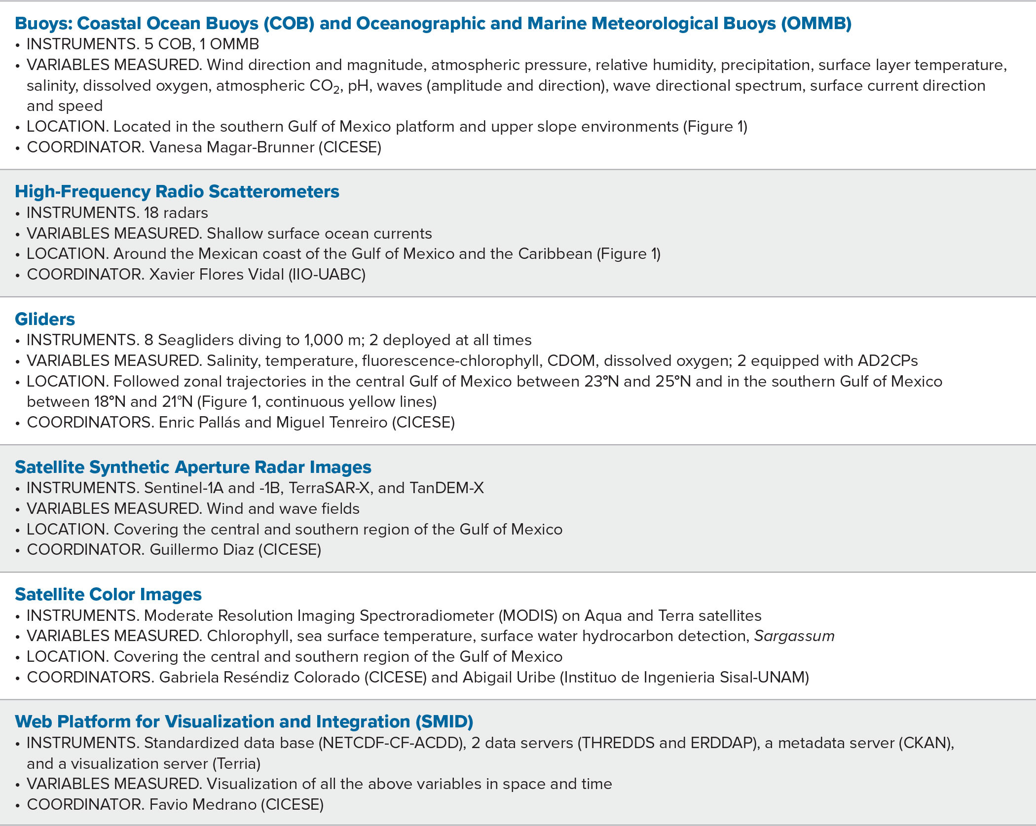
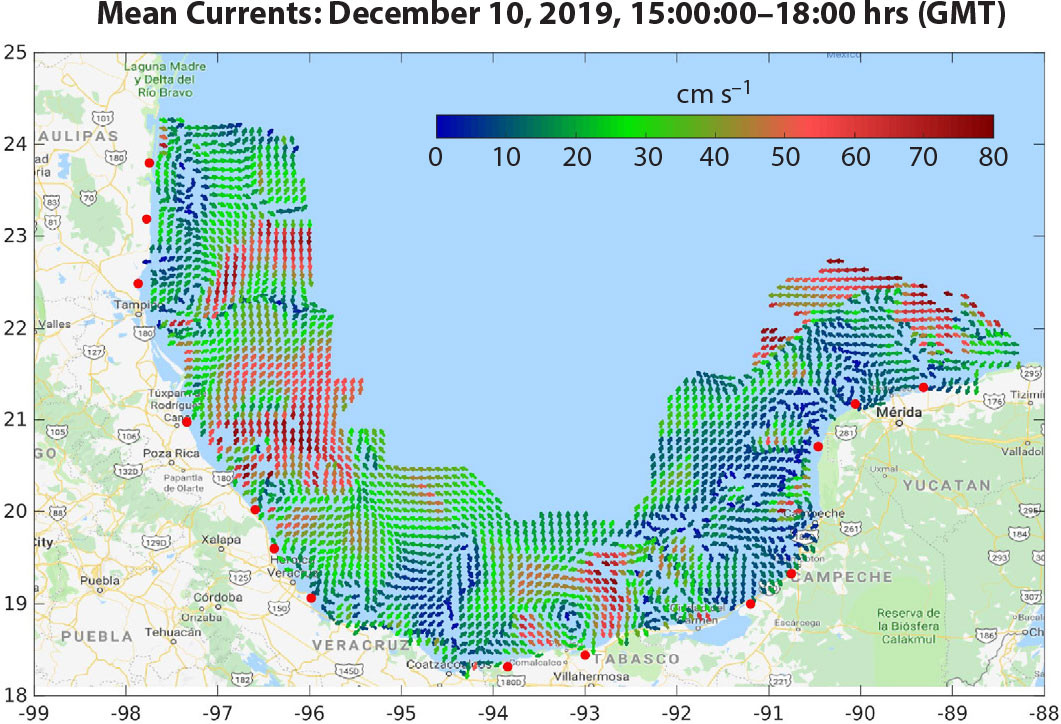
Over the past eight years, CIGoM implemented an extensive observational and modeling effort concerning the deep-sea waters of the southern Gulf of Mexico (GoM; see oceanographic collections at https://atlascigom.cicese.mx/). The collaborative project, which brought together more than 300 researchers from more than two dozen institutions in Mexico and abroad, developed a system of ocean data collection and satellite imagery analysis to continuously observe surface ocean circulation, marine meteorology, ocean waves, and several essential ocean variables, including temperature, salinity, oxygen content, and chlorophyll. The system consists of a network of coastal oceanographic buoys and open-ocean oceanographic and meteorology buoys that were partially developed, designed, and built at the Center for Scientific Research and Higher Education at Ensenada (CICESE; Figure 1 and Table 1). This buoy network transmits continuous hydrographic, oceanographic, and meteorological observations collected from the coastal and oceanic regions of the GoM in real time to CICESE as well as to the Servicios de Manejo Integral de Datos (Comprehensive Data Management Services, SMID; https://smid.cigom.org), a web-based system also developed by CIGoM. A fleet of eight underwater gliders samples the water column continuously from the surface to 1,000 m depth at very high spatial resolution (Figures 1 and 2). A network of high-frequency radars (HFR) on the coast (the only one in Latin America) between Tampico and the Yucatán Peninsula provide continuous measurements of the surface currents up to 170 km offshore over the entire Mexican exclusive economic zone using the Hawai‘i line-array approach (Flament et al., 2016; Figure 3). Data from these assets are complemented by analysis of different types of satellite images, ranging from passive (ocean color) sensors that collect information on sea surface temperature and chlorophyll a to active (synthetic aperture radars) sensors that allow us to analyze wind and wave fields at the ocean surface. All of these observations—from buoys, gliders, drifters, HFR network stations, and satellite imagery—are integrated in the SMID data management and distribution web platform that can simultaneously display these diverse data in different layers for the user.
|
|
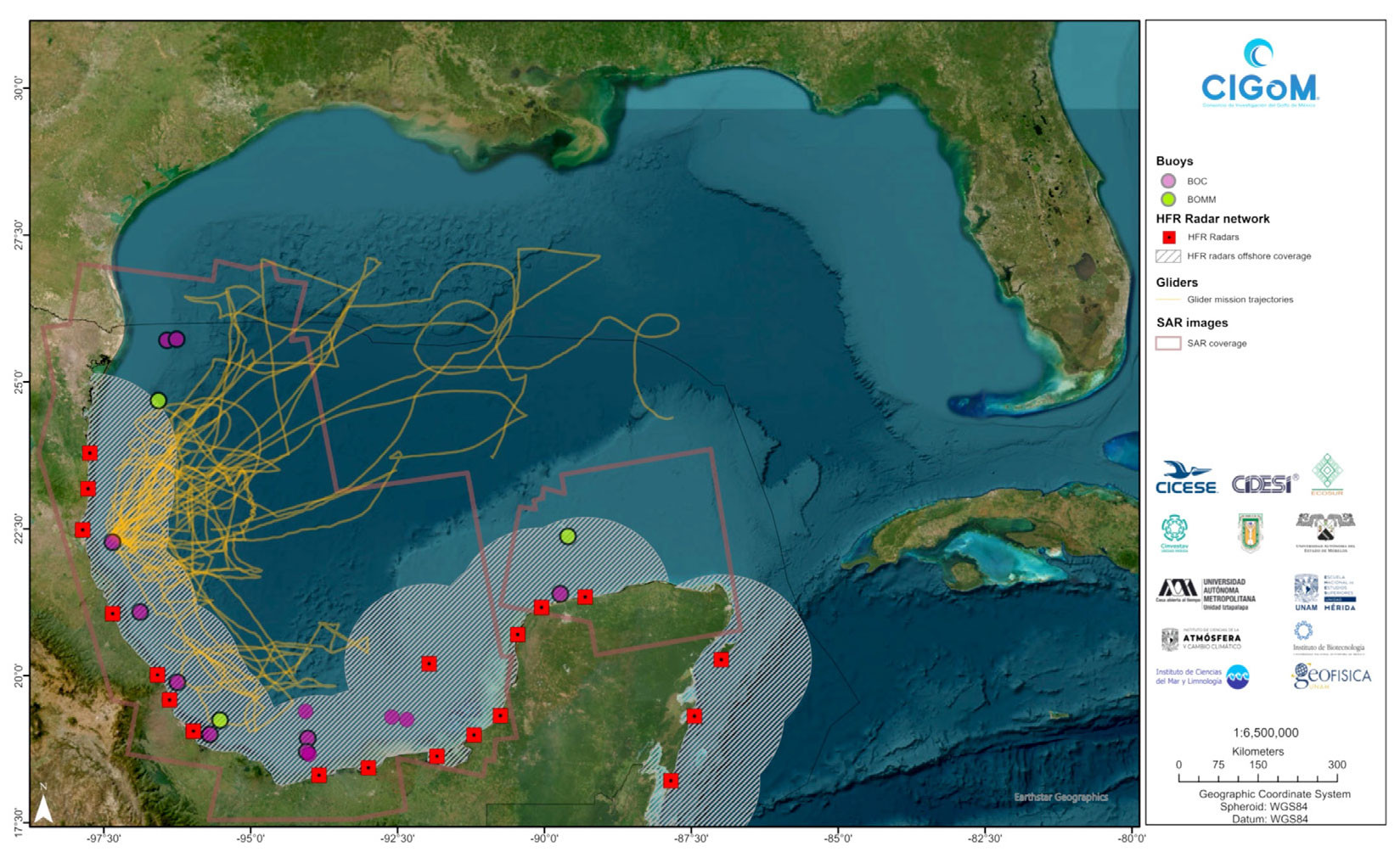
TABLE 1. Observational assets of the Consortium for the Gulf of Mexico (CIGoM). > High res table |
|
|
|
|
Here, we provide a few examples of how our instrument network and modeling efforts are being used for hazard warning in the southern Gulf of Mexico.
Hazard Warning
Hydrocarbon Spills
CIGoM has been working on two strategic capacities, one of them based on satellite observations and the other on models for forecasting oil spill trajectories.
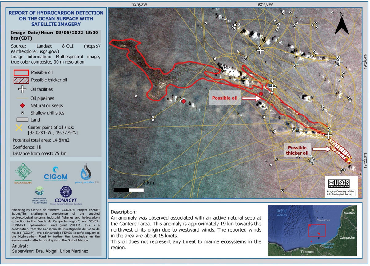
In collaboration with the US National Oceanic and Atmospheric Administration (NOAA) and Mexico’s El Colegio de la Frontera Sur (ECOSUR), CIGoM is developing an oil spill early warning system that covers the southern domain of the GoM, a region characterized by continuous major hydrocarbon industry operations and natural hydrocarbon seeps (Figure 4). To maximize the temporal coverage and spatial detection of large to small spatial scale slicks, we use a combination of three different types of publicly available satellite imagery: the Landsat-Operational Land Imager that measures in the visible, near infrared, and shortwave infrared portions of the spectrum; the Sentinel-1 synthetic aperture radar instrument; and the Sentinel-2 Multispectral Instrument that measures Earth’s reflected radiance.
|
|
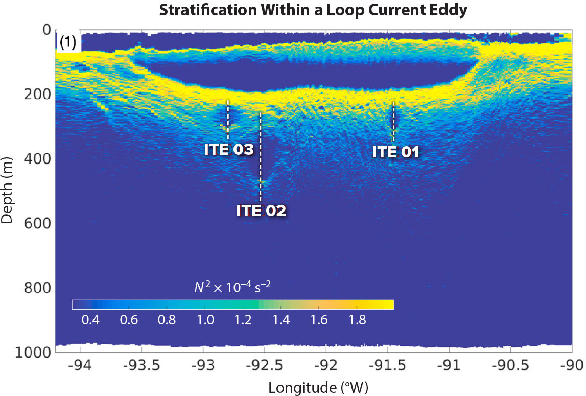
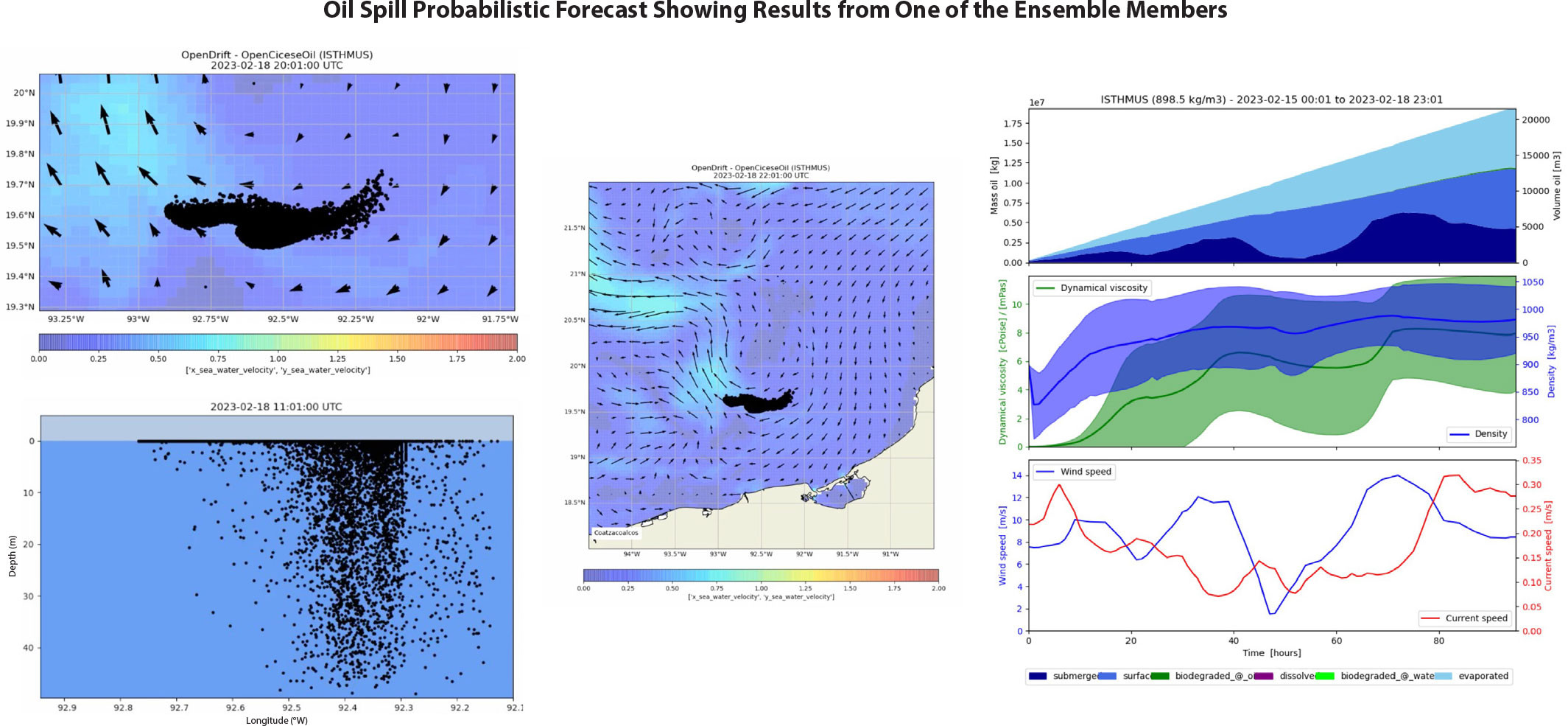
The integrated numerical modeling system developed by CIGoM has provided some interesting results on complex problems related to predicting the dispersion and probable fate of oil during large-scale hydrocarbon spills in the GoM. To forecast and visualize the evolution and fate of different oil spill scenarios at pre-defined locations, we employ several international operational models: the HYbrid Coordinate Ocean Model (HYCOM), the Regional Ocean Modeling System (ROMS), the Nucleus for European Modelling of the Ocean (NEMO), the Navy Coastal Ocean Model (NCOM), the Global Forecasting System model (GFS, NCEI-NOAA), and the Weather Research and Forecasting (WRF) and WRF-Chem for the atmosphere and WAVEWATCHIII for waves. An analysis of the differences and similarities among the modeling results has helped us understand their capabilities and guided their use for development of an ensemble-based system to generate oil spill scenarios and a probabilistic forecast system (Meza-Padilla et al., 2019; Duteil et al., 2019; Gómez-Valdivia and Parés-Sierra, 2020; Mazlo et al., 2020; Moreles et al., 2020; Guerrero et al., 2020; Damien et al., 2021). These ensembles are coupled to three oil spill models of different complexity: OilSpill and PetroTrans (both two-dimensional models) and CIC-OIL (a three-dimensional model) with which we have implemented innovative routines, modifications, and couplings, as well as stochastic parameterizations or models. The CIC-OIL couples the Texas A&M Oil Spill Calculator, a near-field model that simulates “blowout,” and OpenDrift, a far-field software package for modeling the trajectories and fates of objects or substances drifting in the ocean. OpenDrift incorporates features recently developed at CICESE (weathering processes) to simulate the plume produced by the explosion of a well and its evolution (Figure 5). Because the three-dimensional CIC-OIL model simulates many processes (e.g., entrainment and dispersion) with different properties, such as hydrocarbon composition and droplet size, its results can be compared to other models that do not include or parameterize some of these processes (Pares-Sierra et al., 2018; Anguiano-García et al., 2019; Duteil et al., 2019) or models with similar complexity (Meza-Padilla et al., 2021). We are using these models to generate different scenarios, incorporating the impacts of model and initial condition errors (ensemble forecasts) and testing, for example, the use of dispersants either on the surface or at depth, that affect oil characteristics and the fate of oil downstream (see Kotzakoulakis and George, 2021).
|
|
As part of this project, we also developed a novel weather forecasting system for the GoM that consists of two tools that are necessary for reliably predicting the evolution and impact on the atmosphere of a large oil spill event. The first estimates air quality and the second calculates the downstream evolution of polluting plumes associated with the volatilization and burning of hydrocarbons from large-scale spills at the sea surface (see CIGoM air-quality forecast at http://132.248.8.198/CIGOM_PM.php). This meteorological forecast system, in addition to providing information on atmospheric circulation, is essential for planning daily activities at sea such as fishing and marine operations. It is important for executing prevention and mitigation procedures, because knowledge of air quality and the trajectory of gas emissions associated with hydrocarbon spills helps to safeguard public health.
We are currently combining observations from our southern GoM network and modeling efforts to provide an Early Response Protocol for Hydrocarbon Spills that will systematize the role and function of science panels within regional and local coordination agencies. These agencies are responsible for early responses to hydrocarbon and other hazardous spills under the leadership of the Mexican naval command. In the past two years, CIGoM has participated in oil spill drills organized by the Mexican Navy in several major GoM port cities (including Tampico, Veracruz, Ciudad del Carmen, and Campeche), where we provided the Unified Command with different scenarios based on real-time observations and forecasting models and tried to estimate the impacts of alternative actions for mitigating and containing the oil spills.
Tropical Cyclones
Growing coastal populations and rising sea levels magnify vulnerability to tropical storms, increasing the need for more accurate storm intensity and tracking forecasts. Advances in forecasting capability include remarkable improvements in atmospheric forecasts and the use of gliders, which have proven to be reliable observing systems for gathering critical real-time ocean data in regions of potential rapid storm intensification such as the Caribbean and the eastern Gulf of Mexico. Gliders’ ability to obtain upper ocean salinity and temperature profiles and transmit them to shore in real time even under the most severe storm conditions is improving the accuracy of hurricane intensity forecasts (NOAA, 2020). The CIGoM glider group is collaborating with the US Integrated Ocean Observing System to provide data to reduce uncertainties in global forecasting models through improved estimation of ocean heat content. A better understanding of ocean-storm prediction will help to advise stakeholders and prepare coastal populations to react to and mitigate destructive storm impacts. During the 2022 hurricane season, from July to November, three glider missions provided real-time data during the passages of Tropical Storm Karl and Hurricane Lisa over Campeche Bay, demonstrating the importance of the monitoring efforts implemented by CIGoM.
Sargassum Inundations
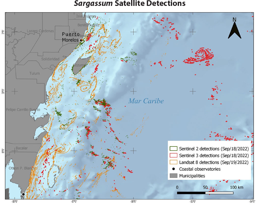
To mitigate the effects of excessive Sargassum deposition on coastal populations, tourism, fishing activities, and coastal marine ecosystems, CIGoM members are implementing an early detection, monitoring, and forecasting system for massive Sargassum landings on the Mexican Caribbean coast. The goal of the project is to provide information to end users about Sargassum distribution at different temporal and spatial scales (from days to weeks and regional to local; Figure 6), and the probability of the timing and approximate locations of landings (also with different scales and scopes). This information will be made available through a dedicated website where observations and forecasts will be publicly available to end users for planning and managing logistics during these events. This multidisciplinary and multi-institutional effort is being constructed along four thematic lines: (1) operational modeling of Sargassum transport and the probability of its landing in a coastal region, (2) detection in the open ocean as well as close to shore, (3) local observations of environmental conditions along the coast during Sargassum inundations, and (4) data dissemination and communication to end users. This system monitors Sargassum biomass landings at two coastal observatories (Puerto Morelos and Xcalak), analyzes their biogeochemical compositions, and assesses their impacts on coastal environments. The system also monitors brown tides in reef lagoon environments.
|
|
Conclusions
The data generated by the CIGoM oceanographic observation system allows characterization of surface and deep-water ocean circulation and biogeochemical processes in the southern Gulf of Mexico. The continuous collection of key oceanographic variables in real time and the knowledge generated from oceanographic cruises and fieldwork, together with the computational modeling efforts, are critical inputs to decision-making regarding mitigation procedures during extreme events originating from natural causes or of anthropogenic origin and for setting the appropriate public policy to maintain the resilience of this large marine ecosystem to natural and anthropogenic disturbances.
In 2022, the UN Ocean Decade of Ocean Science for Sustainable Development (2021–2030) endorsed CIGoM’s Ocean Decade project ID 37, “Ocean Monitoring and Prediction Network for the Sustainable Development of the Gulf of Mexico and the Caribbean.” This project provides large spatial and long-term baseline observations from the network we developed, together with modeling/forecasting capabilities to inform end users and coastal communities that have not so far been able to obtain such information, which is vital for their safety. Our objectives include the maintenance, optimization, and expansion of the metoceanic, hydrographic, biogeochemical, and ecological observations we have been collecting for the past eight years to help us understand, in combination with our numerical modeling efforts, the emerging long-term environmental trends that threaten the habitats and key species of Gulf of Mexico and Caribbean Sea ecosystems.
The communication and use of this information is of great value for implementing safer ways to operate in the ocean, preventing loss of lives during extreme weather events, and conducting mitigation procedures during oil spills, harmful algal blooms, massive Sargassum influxes, and other anthropogenic sources of perturbation to GoM marine life. The observing system for the southern Gulf of Mexico and the western Caribbean that we are attempting to keep functional can become the basic infrastructure for monitoring the emerging trends in sea surface temperatures, ocean acidification, biodiversity loss, and sea level rise, among other processes related to climate change, and to other anthropogenic pressures introduced by plastics and metals pollution and deoxygenation of coastal regions in the area. These accessible data sets and the knowledge generated will further advance the local, national, and international capacities needed for the sustainable development of the ocean resources in this region. Making the system part of global observing and forecasting efforts would further enhance capacity building and inspire the next generation of scientists, policymakers, and stakeholders in the greater Caribbean for the sustainable development of this large ocean region.