Full Text
In 2007, the Calista Elders Council (now Calista Education and Culture, CEC) began a three-year US National Science Foundation (NSF)-funded project to document the history and oral traditions of the Yup’ik people of Nelson Island, located on the Bering Sea coast of southwest Alaska. One project focus was place names, and by 2010 we had recorded over 600 names, including old village sites, rivers, lakes, mountains, and ocean channels. That same year, I gave a presentation on our Nelson Island place name effort at a workshop hosted by the Exchange for Local Observations and Knowledge in the Arctic (ELOKA) project, recently funded by NSF’s Office of Polar Programs. Following the presentation, project lead Peter Pulsifer suggested that ELOKA might be able to help CEC share these names using the Nunaliit Atlas Framework, open-source software for making interactive maps that ELOKA was then in the process of testing.
The next step was for Pulsifer to travel to Bethel, Alaska, and to describe the proposed place name Atlas to CEC’s Yup’ik Elder Steering Committee. Along with discussing how place names could be displayed, a question was posed regarding who should be the intended Atlas audience. Should the Atlas be password protected and open only to Nelson Island community members? Should it be open only to residents in southwest Alaska? Or should it be open globally on the worldwide web? The unanimous response of this group of Yup’ik-speaking elders was that these names were something everyone should know. Yup’ik youth needed to know the names to keep them safe in a changing environment. Equally important, non-Natives needed to know the names. As CEC elder Martin Moore declared, the names were proof that every square inch of land in southwest Alaska had been walked on by his ancestors.
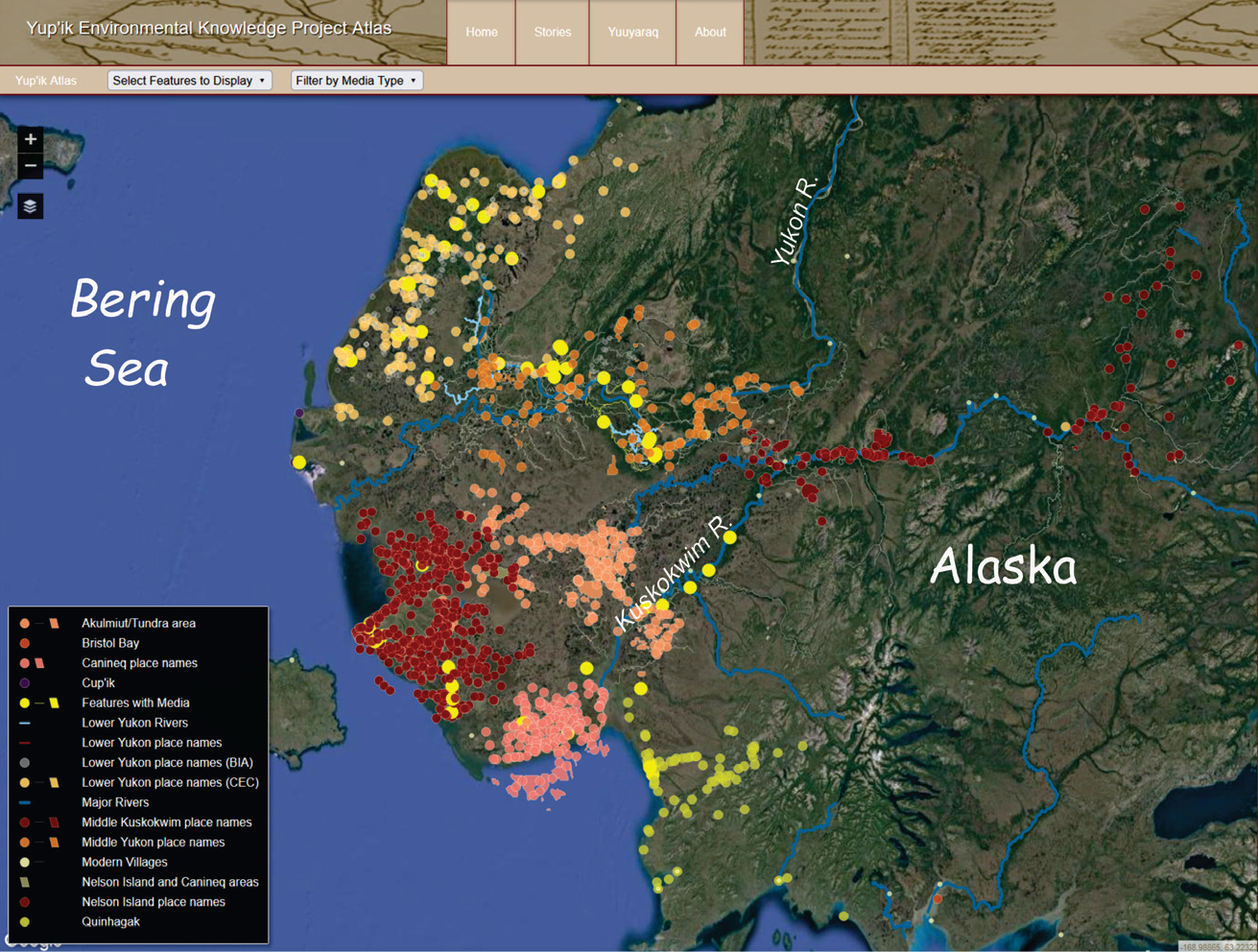
Over the last decade, funded by both NSF and the US Fish and Wildlife Service, CEC has continued a string of regional oral history projects, documenting more than 4,000 place names along the lower Yukon River, the middle Yukon River, and the lower Kuskokwim coast; in the Akulmiut/Tundra Village area; and most recently along the middle Kuskokwim River (Figure 1). Along with adding names, ELOKA staff taught CEC summer interns how to add a Hover Sound to each name, so that Atlas visitors can hear the name as well as view its location. The powerful Nunaliit platform has also allowed staff and interns to add stories—both traditional tales and historical accounts of bow-and-arrow warfare—to selected sites. Photos and short videos have also been added, and (at the request of our Elders Steering Committee) GPS locations of sites are available to download region by region, which is especially valuable to local search and rescue teams. Most recently, translated text has been added so that visitors can view the Atlas in either Yup’ik or English.
|
|
In 2018, a new Yuuyaraq module was added to the Atlas as part of the Yuuyaraq (Yup’ik way of being) ninth-grade life-skills curriculum CEC developed in collaboration with the Lower Kuskokwim School District, which serves 28 schools in southwest Alaska. As part of the curriculum, students not only learn how to use the Atlas, they also are given access to the staging Atlas where they can add place names, stories, photos, and videos from their own areas and experiences. With the skeleton of the Atlas in place, the potential to add new layers of information is infinite. A module focusing on climate change presently in the works will include “story maps” that allow visitors to scroll over a selected modern village in order to see the shape of the surrounding land in the 1950s.
The new climate module under development will also display an interactive map of the Yukon-Kuskokwim delta. The viewer can grab a slider and drag it back and forth to compare two layers that represent different time periods. For example, one map will compare historically derived freeze-up data for 2000–2009 to modeled data at 20-year intervals. Other maps will compare historically derived data to projected delays in fall freeze-up, changes in average summer precipitation, and projected increases in average fall temperatures. This module will be particularly valuable, as it highlights changes projected to occur in numerous coastal locations already present in the Atlas.
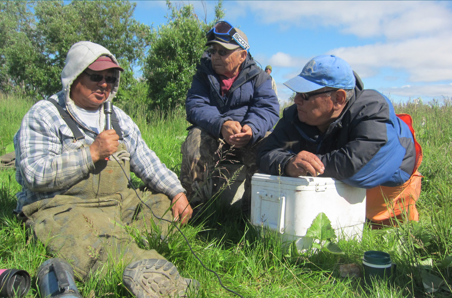
In 2019, the ELOKA team, including Pulsifer, Noor Johnson, and Matt Druckenmiller, visited Bethel once again, both to discuss Atlas progress with the Elders Steering Committee and to provide training to Lower Kuskokwim School District staff. Growing the Atlas in a region of Alaska with low bandwidth, limited technology, and exorbitant internet costs has been challenging. Yet savvy students have used their iPhones to record elders sharing aspects of a lived tradition still highly valued in their communities (Figure 2).
|
|
Many have observed that it is traditional among Arctic peoples to use the best technology available. The Yup’ik Environmental Knowledge Project Atlas (https://eloka-arctic.org/communities/yupik/atlas/) is state-of-the-art, with capacity to add audio, video, text, and photos to any single point or line. Yet in many areas it is a skeleton without flesh. The goal of our most recent project is to work with an array of partners—local tribal governments, school districts, statewide institutions, and national and international institutions—to build on what ELOKA has created, not from the outside in but rather beginning at the village level, to continue developing a vehicle to share Yup’ik history from the Yup’ik point of view.
Villages today struggle to find relevance socially, economically, and culturally. From the beginning, Yup’ik elders and community members have advocated for creating both CEC-sponsored books (many authored and edited by myself and my co-worker Alice Rearden) and the ELOKA Atlas as ways to educate their youth, as well as the larger world, about Yup’ik language and traditional knowledge. In 2009, Nelson Island leader Paul John compared the effect of our documentation efforts to that of the election of President Obama. He said, “If white people see these books, they will think, ‘These Yup’ik people evidently are knowledgeable and know how to take care of their own affairs through their traditional ways.’ Like the African-American who has become president, our young people will be able to independently practice their way of living.”
Our work with the Yup’ik Atlas seeks to make Paul John’s vision a reality—working with elders and youth to present Yup’ik history in new formats that will allow them to sustain these living traditions in a global world. Elders maintain that if youth not only know their history and take pride in it but also have a role in creating it, their future will be brighter.