Full Text
As previously summarized by Hammond et al. (2015), from 1983 to 2013, the NOAA Vents program conducted systematic and multidisciplinary exploration, discovery, and research related to hydrothermal vents, submarine volcanic eruptions, and associated ocean physical, chemical, and biological processes. In 2014, Vents divided into two programs, Earth-Ocean Interactions (EOI) and Acoustics, and considered a broader range of questions about how seafloor and subseafloor processes contribute to ocean health, biogeochemical cycles, ecosystem diversity, and climate change. Here, we highlight major accomplishments since 2014, including deep-sea technologies that EOI, Vents, and Pacific Marine Environmental Laboratory (PMEL) Engineering have developed to advance marine science. EOI research is driven by a need for better observational data on issues of global importance, including the role of continental margin seeps in the global methane/carbon cycle, benthic ecology, and fisheries habitat; the role of hydrothermal systems in global biogeochemical cycles, including carbon dioxide removal; the potential impact of deep-sea mining of metal sulfides on ecosystem services provided by hydrothermal vents; and how hydrothermal iron functions as an essential nutrient. NOAA Ocean Exploration, the Schmidt Ocean Institute, the Ocean Exploration Trust, and the National Science Foundation have supported and collaborated in this work. Global exploration of the deep sea with the purpose of understanding global ocean processes remains a cornerstone of EOI science.
|
|
Continental Margin Seeps: Exploration, Characterization, and Research
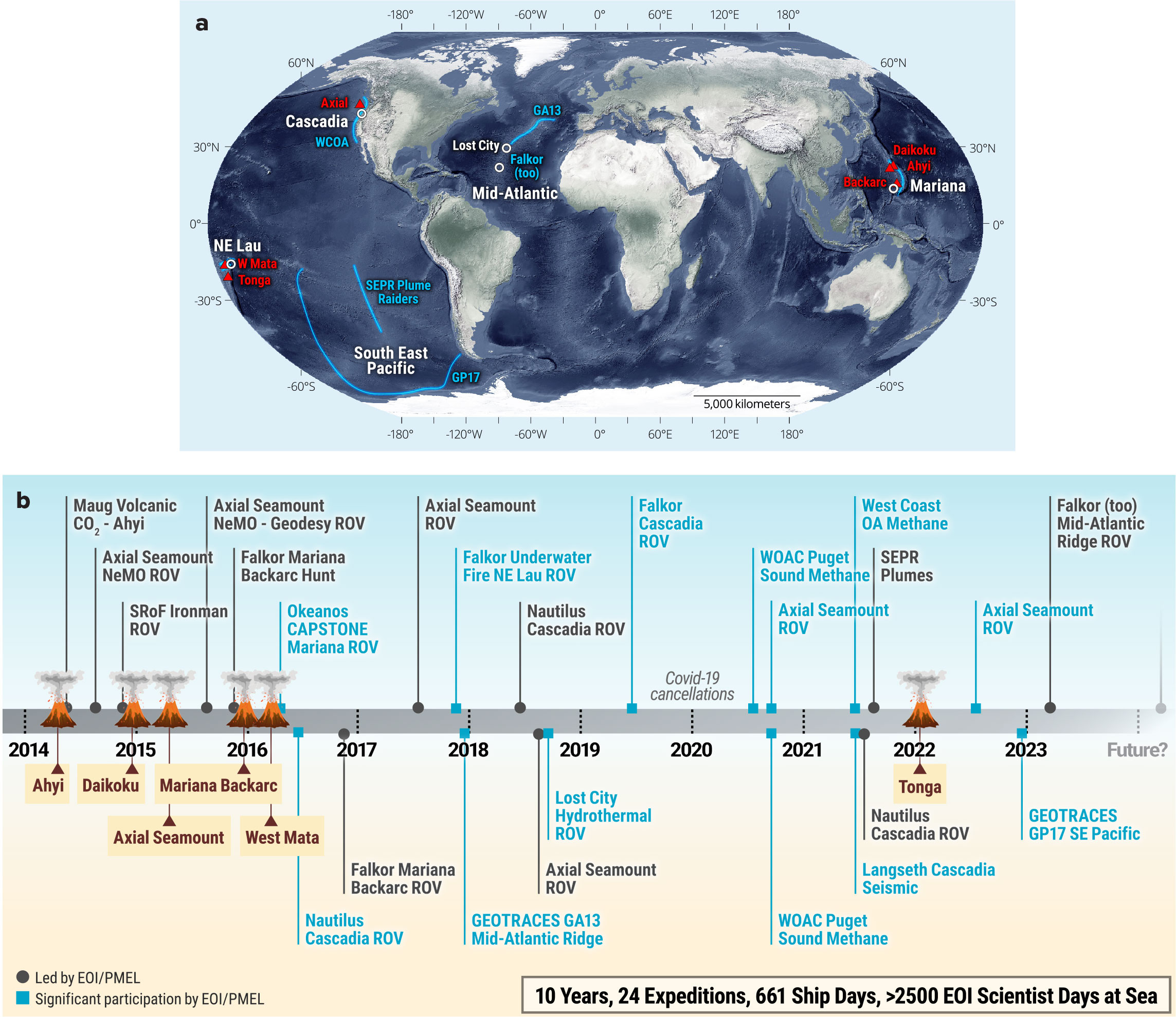
Seeps have been known on the Cascadia Margin since the 1990s (Suess et al., 1999; Rehder et al., 2002; Collier and Lilley, 2005; Heeschen et al., 2005), but the pace of discovery of gas seeps increased greatly when the application of sonar backscatter for detecting gas bubbles in the water column revealed that seeps are ubiquitous on the continental shelf and slope (Riedel et al., 2018; Johnson et al., 2019; Merle et al., 2021). Several EOI-led cruises since 2016 (Figure 1) have been instrumental in systematically mapping and characterizing methane seeps within the US Cascadia Margin, resulting in a foundational database and inventory of nearly 3,500 bubble seep locations, grouped into over 1,300 seep sites, at water depths ranging from 100 m to >2,000 m (Merle et al., 2021). The mapping coverage represented in this database is still only ~40% of the entire Cascadia Margin seafloor area, so many thousands more seeps are likely present. Seeps release methane into the water column, create carbonate hard ground habitat, and host the conversion of chemosynthetic energy into biomass that radiates into the benthic environment (Levin et al., 2016), raising the importance of exploration and characterization of coastal margin seeps. Merle et al. (2021) found a high incidence of gas plumes on the shelf in water shallower than 200 m. The shelf remains largely un-surveyed for bubble plumes, so it is likely that many more seep sites will be located in the future at shallow depths where methane is more likely to reach the atmosphere (Michel et al., 2021).
|
|
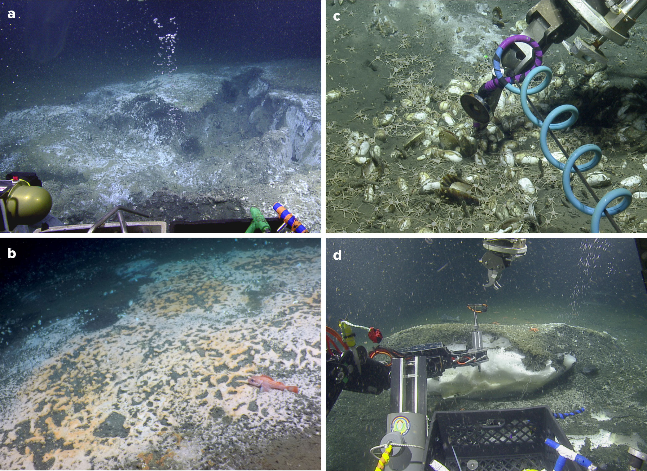
EOI has contributed to the exploration, enumeration, and characterization of methane seeps along the Cascadia Margin (Figure 2) by organizing and leading cruises (Figure 1) and publishing results on the distribution of seeps (Merle et al., 2021; Johnson et al., 2022), the chemical and isotopic compositions of seep gases and their origins (Baumberger et al., 2018), the variation of microbial communities across seep sites (Seabrook et al., 2018), and the acoustic signatures of seeps (Dziak et al., 2018). A survey of methane on the 2021 NOAA West Coast Ocean Acidification cruise indicates that methane from seeps reaches the surface ocean over the continental shelf and upper slope (Butterfield et al., 2022), contributing to the marine methane flux to the atmosphere.
EOI has contributed to technology development for understanding seeps with a new gas-tight methane hydrate sampler (Figure 2d; Lupton et al., 2018) and field testing of a deep-sea laser spectrometer built by Opto-Knowledge Systems Inc. for in situ methane analysis. EOI work on Cascadia Margin has primarily been supported by the NOAA Office of Ocean Exploration (OE) and PMEL in partnership with the Ocean Exploration Trust (OET), using OET’s E/V Nautilus and its remotely operated vehicle (ROV) Hercules. OET prioritizes public education and outreach, as well as making data widely available, so these EOI cruises and discoveries have received significant media and public interest while contributing substantially to national data repositories.
|
|
The diversity of Cascadia methane seeps is still being uncovered, and given that only ~30 of the thousands of seep sites have been visited and sampled by human-occupied vehicles (HOVs) or ROVs, there is much more to explore and discover. Correlation between an anomaly in the deep subseafloor structure, from 2021 R/V Langseth seismic reflection data and the distribution of seep locations from acoustic water column data, led to the discovery of a rarely observed warm seep at the base of the continental slope ~15 km east of the Cascadia deformation front offshore southern Oregon (Beeson et al., 2022). The warm seep implies that the fluids are rising from deep within the continental margin, probably along an active fault. An open question for future studies is to determine how common or rare such warm seep sites may be and if monitoring them may provide valuable information about tectonic stresses and earthquake potential within the subduction zone (Phillip et al., 2023).
Hydrothermal Vents and Submarine Volcanoes
EOI contributes to exploration, discovery, and research on seafloor hydrothermal vents and volcanic processes (Figure 1). Data from instruments built by PMEL and installed as part of the Ocean Observatories Initiative (OOI) network led to the successful forecast of an eruption at Axial Seamount (Juan de Fuca Ridge, Northeast Pacific Ocean) in 2015, and previously scheduled field work allowed for characterization of the new lava flow and changes in hydrothermal discharge (Chadwick et al., 2016; Baker et al., 2019).
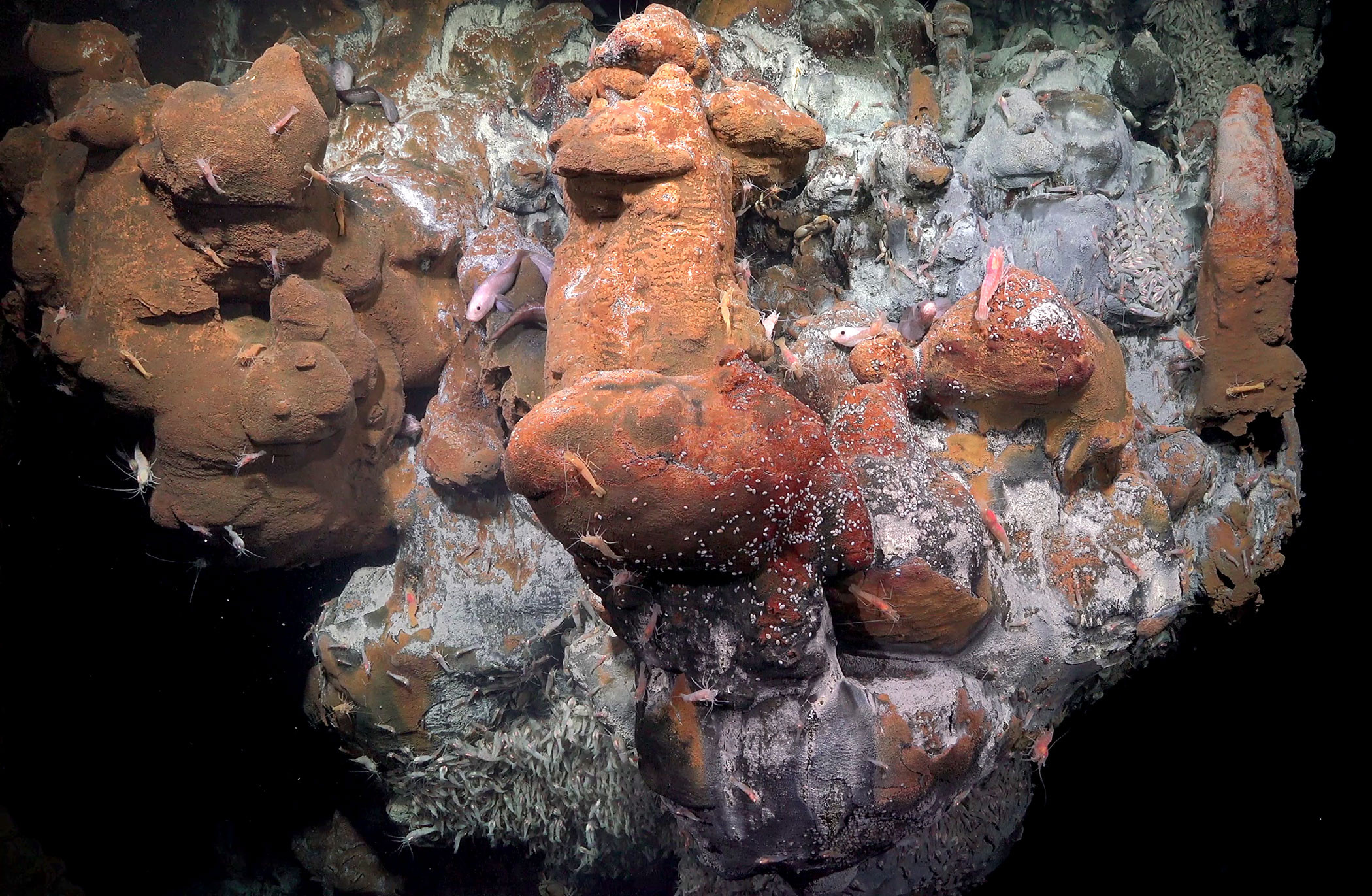
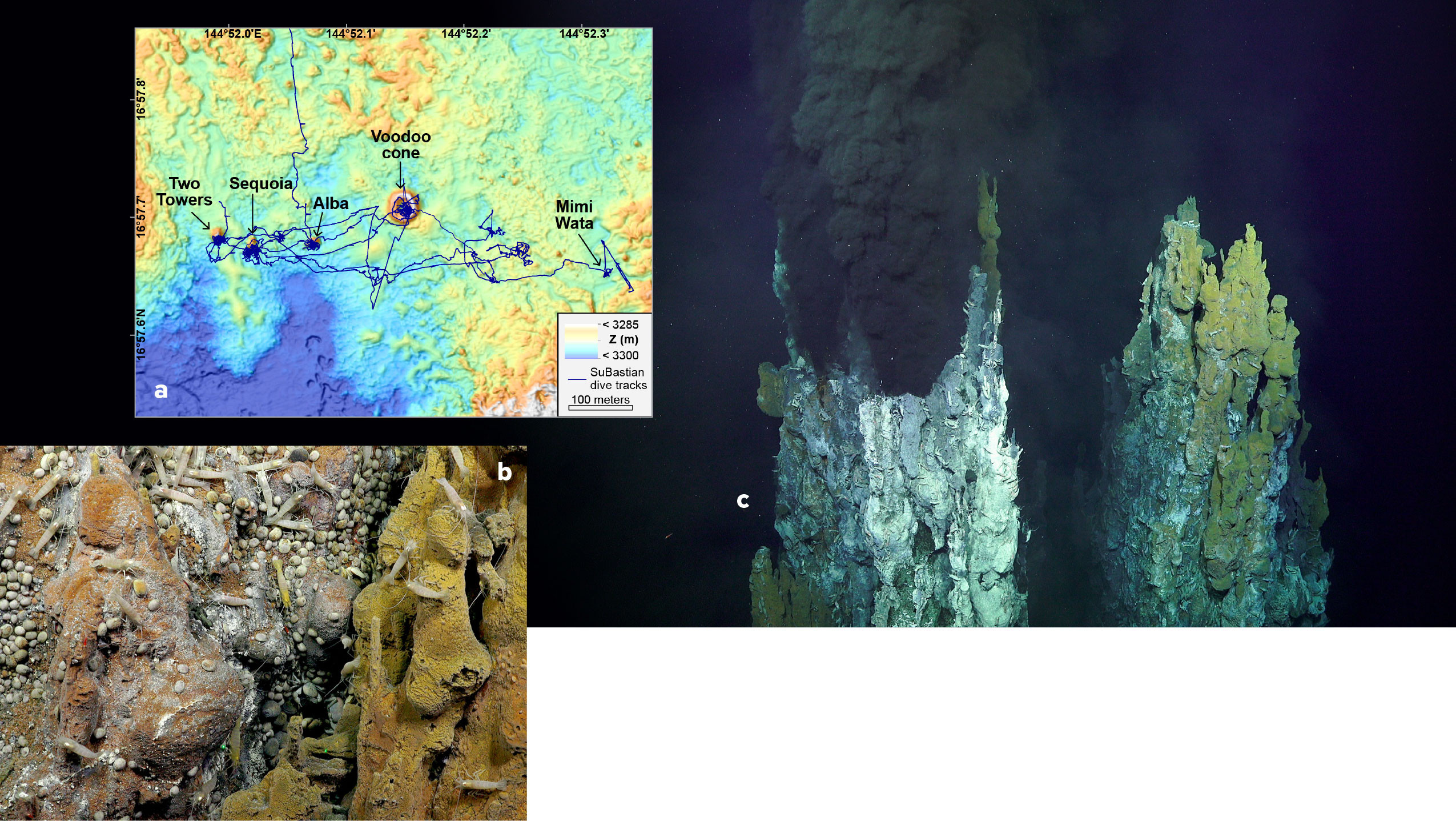
Exploration of the Mariana back-arc basin from R/V Falkor in 2015 (one of many collaborations with the Schmidt Ocean Institute) resulted in the detection of plumes from 13 previously undocumented vent sites (Baker et al., 2017). Subsequent NOAA Ship Okeanos Explorer/ROV Hercules and Schmidt Ocean Institute R/V Falkor/ROV SuBastian dives in 2016 at four of the newly detected hydrothermal areas, including a recent and still-cooling back-arc lava flow (Chadwick et al., 2018) and a large high-temperature vent field at 17°N (Figure 3), provided essential data for comparing the biology and geochemistry of arc and back-arc settings (Brunner et al., 2022).
|
|
In March–April, 2023, an EOI-led team of international researchers employed water column surveys, high-resolution bathymetric mapping with two Monterey Bay Aquarium Research Institute autonomous underwater vehicles, and ROV dives during the inaugural expedition of the new Schmidt Ocean Institute R/V Falkor (too) to explore three target areas along the Mid-Atlantic Ridge. The FKt230303 expedition (https://schmidtocean.org/cruise/in-search-of-hydrothermal-lost-cities/cruise-log) discovered three new high-temperature hydrothermal systems between 20°N and 25°N, including vents on two off-axis oceanic core complexes and one on-axis volcano. The only active hydrothermal areas previously known in this section of the Mid-Atlantic Ridge, Snake Pit and the Trans-Atlantic Geotraverse (TAG) field, were both discovered in 1985.
With mounting pressure to supply critical minerals for electric vehicles and other technology as the climate crisis intensifies, there is an ongoing debate about the need for, the economic feasibility of, and the degree of environmental harm to be expected from deep-sea mining of hydrothermal mineral deposits and manganese nodule deposits. Continuing to gather scientific data about deep-sea hydrothermal sites is of primary importance in order to understand the ecosystem services they provide and to develop science-based environmental management plans to protect ocean health and regulate deep-sea mining (Boschen et al., 2016).
Most metals exiting the seafloor at hydrothermal vents form near-field mineral deposits (e.g., mounds and chimneys) or precipitate and settle to the seafloor close to their sources. However, hydrothermal iron is transported more than 4,000 km west from the southern East Pacific Rise across the south Pacific Ocean basin (Resing et al., 2015) in a plume that aligns with the well-documented hydrothermal helium (3He) plume (Lupton and Craig, 1981; Lupton, 1998). Iron is an important, and often limiting, micronutrient for primary production in the surface ocean, and hence, has a significant role in converting CO2 to particulate carbon and exporting it to the seafloor. Characterizations of the distribution and magnitude of hydrothermal iron sources (Resing et al., 2015; Baker et al., 2016; Buck et al., 2018) and transport mechanisms (Wang et al., 2021; Tagliabue et al., 2022b; Lough et al., 2023) are critical factors in modeling how and where primary productivity depends on hydrothermal iron, and improved understanding of these factors could help evaluate the feasibility of ocean iron fertilization as a CO2 removal mechanism. Modeling studies connect hydrothermal iron to primary production and the global carbon cycle, especially in the Southern Ocean where hydrothermal iron may be responsible for 15%–30% of the export production south of the Polar Front (Resing et al., 2015; Tagliabue and Resing, 2016). Modeling also predicts that hydrothermal venting in or near the Southern Ocean is likely to be the most important source area of hydrothermal iron for carbon export (Tagliabue and Resing, 2016). This model prediction is supported by recent observations of elevated iron and manganese above the Pacific-Antarctic Ridge crest (Tagliabue et al., 2022a). The discovery of hydrothermal activity on the Australian-Antarctic Ridge (Hahm et al., 2015), combined with the presence of this venting below a massive phytoplankton bloom in the surface Southern Ocean (Schine et al., 2021), has inspired an expedition to this region by EOI scientists and collaborators that is scheduled for 2025. Its objective is to definitively link hydrothermal venting and primary productivity in the Southern Ocean.
Deep-sea exploration contributes to understanding how seafloor processes impact ocean biogeochemistry, support sustainable resources, pose potential hazards to coastal communities, and contribute to the accumulation or removal of greenhouse gases in the atmosphere. Most of the seafloor is still unexplored, including large tracts of the US exclusive economic zone and most of the Southern Ocean. The submarine portions of the Aleutian arc, where there are many active subaerial volcanoes, have been neither mapped with sufficient resolution nor systematically surveyed for submerged hydrothermal/volcanic activity. The territories of the Northern Mariana Islands, American Samoa, and the US Virgin Islands are all located near submarine arc volcanoes, many of which were shown to be active through Vents and EOI explorations. The massive eruption of the Hunga Tonga-Hunga Ha’apai volcano in January 2022, and resulting tsunamis, highlighted the importance of understanding the hazards posed by submarine arc volcanoes with summits near the sea surface, as well as the role of shallow eruptions in stimulating ocean productivity (Bonnet et al., 2023). The PMEL EOI program aims to continue to explore and contribute to the development of innovative technology and ocean/seafloor observation methods to address current and emerging issues of scientific and societal importance.

