Full Text
The altimetry from NASA’s ICESat-2 orbiting observatory addresses science requirements that pertain to the monitoring of changes in sea ice, ice sheets, ocean circulation, and vegetation biomass (Markus et al., 2017). Retrievals from the ICESat-2 (IS-2) mission add to the valuable multidecadal record of elevation changes from previous and forthcoming altimetry missions for understanding geophysical processes and for climate monitoring, forecasts, and projections. Launched in September 2018, the second-generation spaceborne lidar onboard the Advanced Topographic Laser Altimeter System (ATLAS) employs a unique photon-counting approach for profiling the surface. ATLAS utilizes a low pulse-energy laser (at 532 nm) in a six-beam configuration that allows cross-track profiling and improved spatial resolution. On the surface, three beam-pairs (with intrapair spacings of 90 m) trace ground tracks separated by about 3.3 km. Each pair consists of a strong and a weak beam, and the pulse energies of the strong beams are about four times those of the weak. For range determination, photon detectors allow centimeter-level roundtrip timing of transmitted photons and individual scattered photons from the surface. At orbital velocities and a pulse repetition rate of 10 kHz, laser footprints of ~11 m (in diameter) are separated by ~0.7 m. This can be contrasted with the 167 m spacing between nonoverlapping ICESat (operated between 2003 and 2009) lidar footprints ~50–70 m in diameter.
For the ice-covered oceans, ATLAS is tasked with providing the height of sea ice and local sea surfaces for calculation of freeboard—the vertical height of the floating ice above the local sea level. For freeboard determination, high-resolution ATLAS samples (of tens of meters with vertical precision better than a few centimeters) are key to obtaining local sea level in open leads as the heights of samples in narrow openings could easily be contaminated by adjacent ice surfaces with higher surface reflectance. Assuming isostatic equilibrium of the floating ice, the retrieved total freeboard (snow plus ice) facilitates estimation of the thickness of the Arctic and Southern Ocean sea ice covers. The smaller lidar footprint, higher height precision, and pulse repetition rate selected for ATLAS stem from lessons learned in the use of ICESat data (lower resolution and sample spacing) for freeboard retrieval. For understanding changes in geostrophic circulation, the altimetry of sea surface heights in open leads at high polar latitudes, not available from traditional open ocean altimeters (e.g., TOPEX/Poseidon), adds to observations of the time-varying sea surface from on-orbit polar orbiting platforms (e.g., CryoSat-2) within the ice-covered ocean. Photon-counting altimetry also offers the opportunity for adaptive sampling of the surface at variable length scales for improved resolution of surface roughness. Hence, IS-2 sea ice products have a unique character compared to altimetry from traditional approaches.
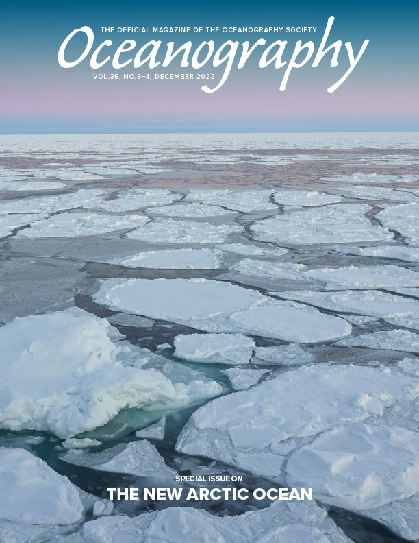
IS-2 sea ice heights have been assessed from the Airborne Topographic Mapper (ATM) lidar (1 m diameter footprint) in four dedicated Operation IceBridge under-flights during the 2019 Arctic deployment (Figure 1 shows one such comparison). From the near-coincident retrievals, in a mix of seasonal and older ice, we found remarkable correlations (averages to >0.95) and near-unity regression slopes. Even with potential mis-registrations between profiles due to location and ice drift residuals, the results indicate close agreement of the height estimates. Larger differences between the surface heights are seen in rougher areas where it is more difficult for the photon heights to capture the surface distributions at short length scales. Differences in total freeboard in available 10 km segments show a variability of 0.02 m to 0.04 m.
|
|
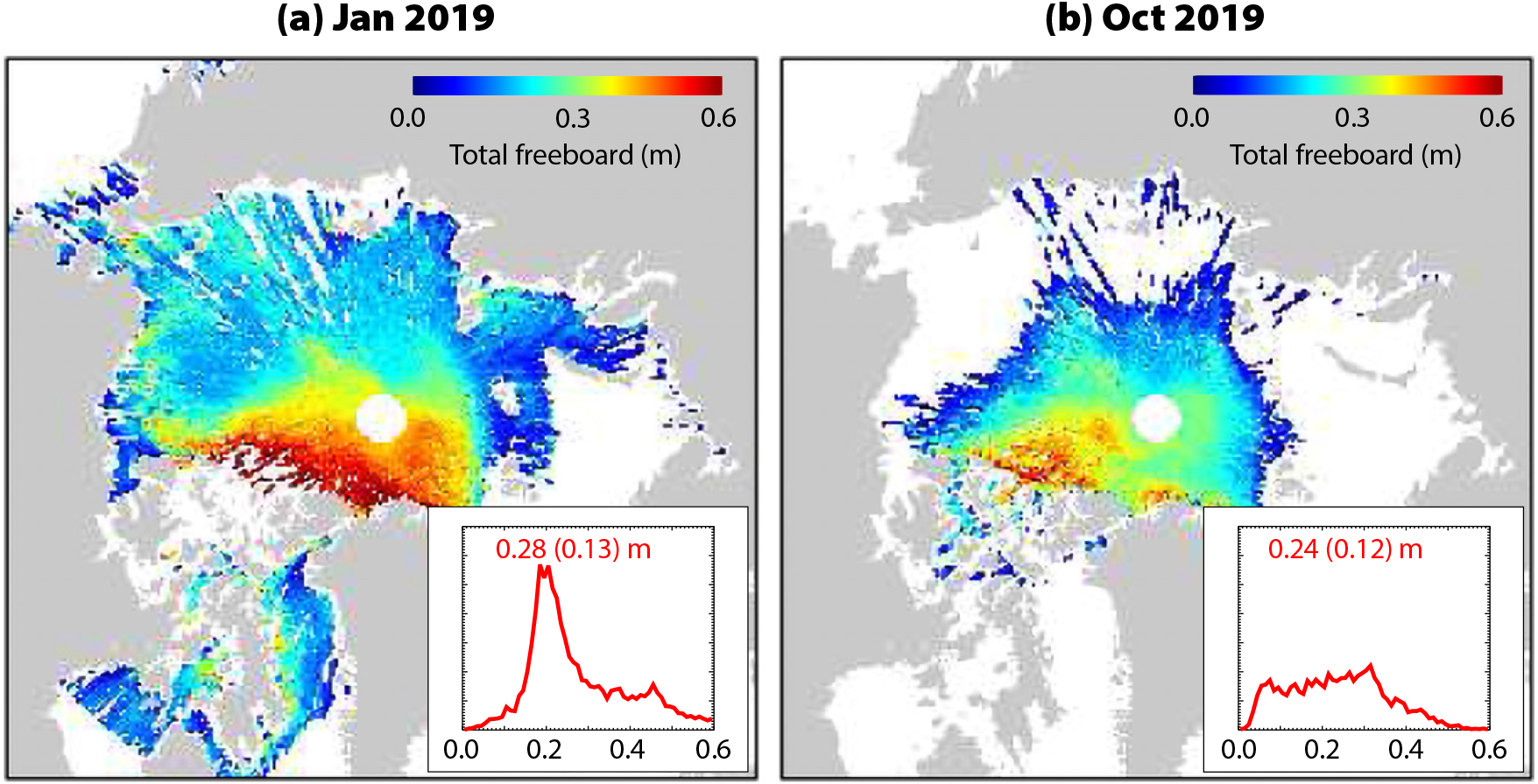
Over the ice-covered oceans, retrieved surface heights and total freeboards from the multiple ATLAS beams are provided in high resolutions (tens of meters) along-track (product designation: ATL07 and ATL10) and in gridded monthly composites of sea ice freeboard (ATL20) and sea surface height anomalies (ATL21). These sea ice and ocean products are available through the National Snow and Ice Data Center (https://nsidc.org/data/icesat-2). Two sample freeboard composites and distributions (Figure 2) from IS-2 sea ice products show the range of freeboard and spatial character of the Arctic ice cover in midwinter and early fall. Current investigations by the IS-2 science team have focused on (to name but a few): in-depth assessment of these products; variability of ice thickness from different approaches used to estimate snow loading, surface roughness, behavior of freeboard, and thickness in summer; retrieval of melt-pond coverage and depth during melt; the impact of waves in freeboard determination; the compactness of the ice cover; and floe size distributions. With progress in understanding ATLAS acquisitions, numerous efforts to introduce new value-added products (e.g., snow depth) and novel uses of photon-counting altimetry for sea ice and other disciplines are being explored (e.g., blowing snow over the ice cover, uses of sub-surface returns). A list of IS-2 related publications on recent scientific results are available at https://icesat-2.gsfc.nasa.gov/publications.
|
|
As of December 2021, ICESat-2 had completed its three-year prime mission and is currently in extended operation. The nonstop operations (with only a few short interruptions) have provided all season coverage of the polar oceans. The ATLAS instrument remains healthy and is using its primary laser (the first of two), and the spacecraft has sufficient fuel to last through at least early 2030.