Introduction
Community science can be broadly categorized as research collaborations that center and involve members of the public to collect data, answer questions of high community importance, and utilize place-based knowledge to empower community members to improve their quality of life (Charles et al., 2020). Community science frameworks can increase the environmental literacy of the general public on complex topics such as king tides, coastal flooding, and sea level rise. A growing body of literature provides evidence for the many benefits that community science provides to its participants, communities, and ecosystems, including increased scientific and environmental literacy, a stewardship ethic and sense of place, engagement in local issues and decision-making, generation of low-cost community solutions to fill data gaps, and increased coastal community resilience (Conrad and Hilchey, 2011).
The Role of Community Science in Promoting Climate Adaptation
Advances in scientific research have improved our understanding of coastal processes and the impacts of such coastal hazards as king tide flooding and sea level rise. However, greater scientific understanding of climate change and its impacts has not led to greater public concern or media attention (Leiserowitz, 2005; Akerlof et al., 2017). In fact, sea level rise risks and associated impacts like coastal flooding are generally perceived as taking place in a distant future and place (Covi and Kain, 2015) despite growing evidence that the frequency of coastal hazard impacts such as nuisance flooding (Sweet and Park, 2014) and coastal erosion (Romine et al., 2013) are increasing and already impacting communities at the local level (May et al., 2023).
Visuals are a compelling way to communicate vulnerability and risk. In particular, visuals that are place-based drive the message home that climate impacts are indeed local in nature (Nicholson-Cole, 2005). Community science can promote climate literacy and climate adaptation by moving participants from an understanding of sea level rise that is abstract, technical, happening in a distant future, or in a faraway place toward an understanding of sea level rise that occurs at personal and immediate temporal and spatial scales (McMichael et al., 2021). Sea Grant programs across the country have been successful in leading projects, such as king tide community science projects, that convey the urgency and proximity of sea level rise impacts and flooding to coastal communities (Bilotta et al., 2018). In these community science programs, volunteers become important contributors in conversations about climate adaptation instead of passive recipients of climate science information.
King tides, or the highest high tides of the year, constitute a unique coastal hazard because their timing can be anticipated months in advance. Their predictability allows for enough time to recruit, train, and coordinate community scientists. King tide impacts can range from road closures caused by flooding, overwhelmed stormwater systems, inundation in low-lying areas, and damage to the built environment to disruption to coastal economies, saltwater intrusion in agricultural areas, damage to freshwater supplies, and increased coastal erosion on beaches.
Sea Grant King Tides Projects
Among 78 Sea Grant network community science programs, four directly monitor king tides. Here, we describe three programs that highlight the effectiveness of Sea Grant community science programs in combining expertise in extension, communications, education, and research to create educational resources that advance sea level rise adaptation. As boundary organizations, Sea Grant programs serve as facilitators and science communicators that establish trust among stakeholders, making them uniquely positioned to carry out place-based projects (Newton Mann et al., 2017).
Hawai‘i Sea Grant’s Hawai‘i and Pacific Islands King Tides Project
Since 2015, Hawai‘i Sea Grant has led the Hawai‘i and Pacific Islands King Tides Project in which volunteers utilize a web entry form to submit photographs and their observations of king tide impacts as well as spatial and temporal data connected to the photos (Figures 1 and 2). These photos become part of the project’s interactive map (https://www.pacioos.hawaii.edu/king-tides/map.html). To date, community scientists have contributed over 4,000 unique photographs from Hawai‘i, American Samoa, the Republic of the Marshall Islands, and Guam. Hawai‘i Sea Grant also organizes workshops where volunteers receive training in sea level rise science and join facilitated discussions about potential community-level adaptation activities.
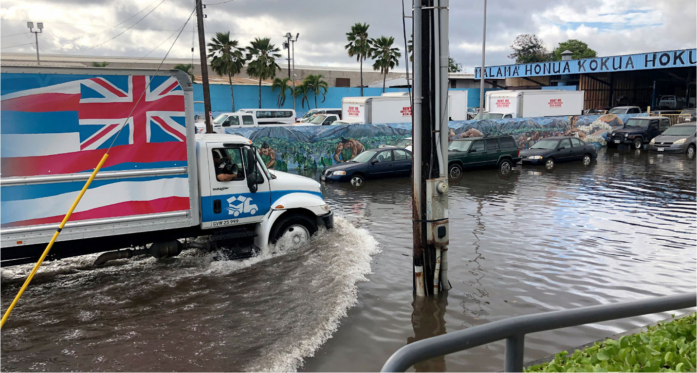
FIGURE 1. Community scientist photos record a range of king tide impacts. This 2019 photo from Mapunapuna, Hawai‘i, documents slowed traffic and a potential road closure caused by high tide flooding. > High res figure
|
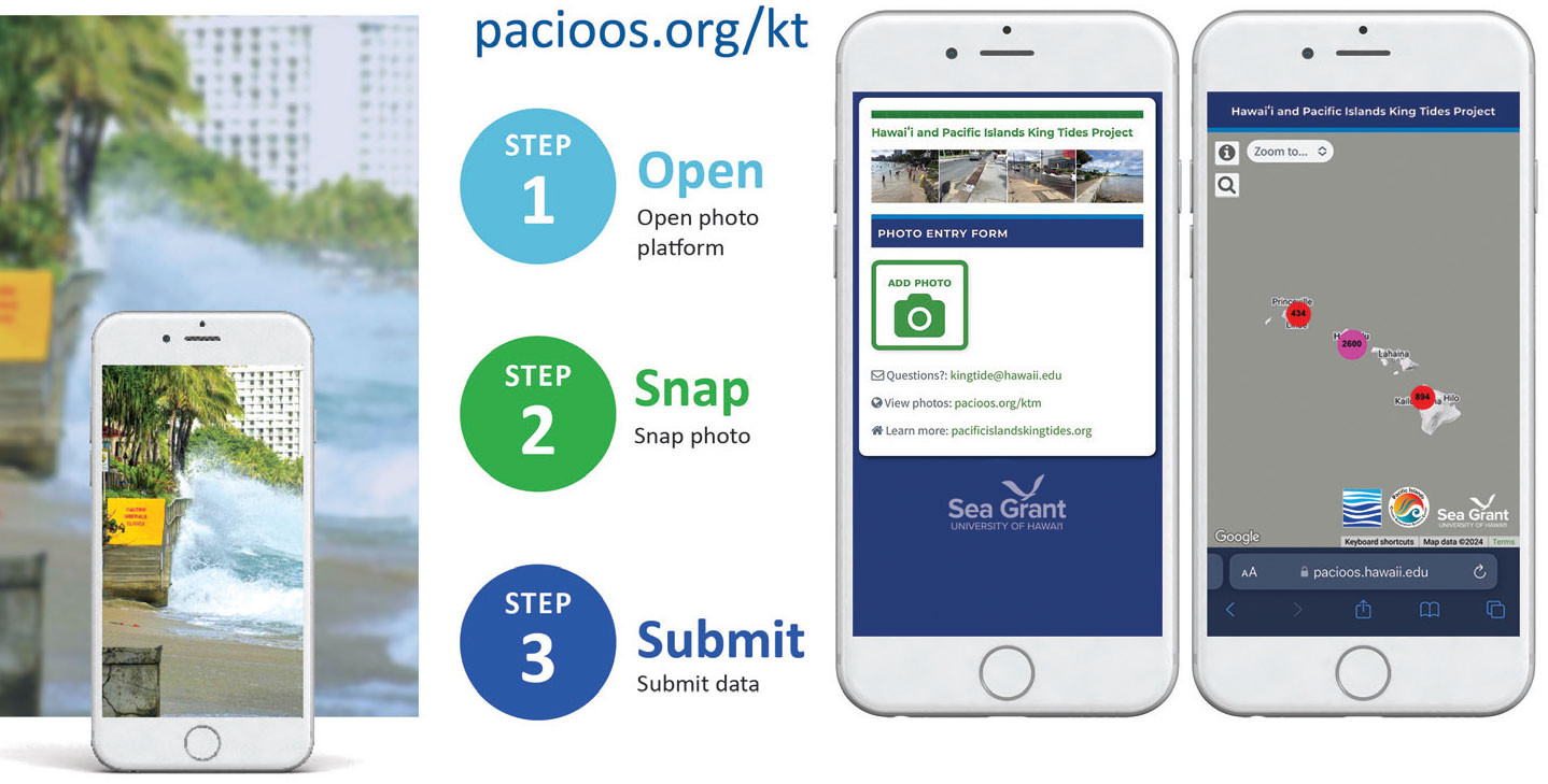
FIGURE 2. Sea Grant employs user-friendly and web-based tools like a website photo entry form (middle panel) and an online database (right panel) to document and visualize sea level rise impacts. > High res figure
|
University of Southern California Sea Grant’s Urban Tides Program
Launched in 2015, the Urban Tides Program documents tidal lines, beach erosion, coastal flooding, and other changing coastal conditions in urban Southern California. The University of Southern California (USC) Sea Grant pairs a community science program with Urban Tides Beach Walks led by extension agents. The walks are guided excursions along coastlines with community members, scientists, and local leaders that serve as opportunities to build relationships among practitioners, community members, and USC Sea Grant; learn about local priorities; and share information about current and future sea level rise risk (Figure 3). To date, community scientists have contributed over 3,000 unique photographs to the program.
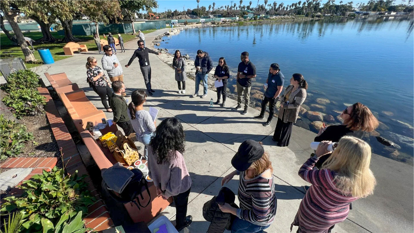
FIGURE 3. USC Sea Grant staff are shown ready to lead city officials on an Urban Tides Beach Walk to explore sea level rise impacts on urban infrastructure during a king tide event in January 2023. Photo credit: Andrew Davidov. > High res figure
|
New York Sea Grant’s Community Flood Watch Project
The Community Flood Watch Project was launched in 2018 to enhance understanding of the social impacts of tidal flooding in low-lying neighborhoods around Jamaica Bay, New York City, after residents noticed high tides were regularly flooding streets. Flood Watch is co-led by New York Sea Grant and the Science and Resilience Institute at Jamaica Bay in collaboration with the NYC Mayor’s Office of Climate and Environmental Justice and the NYC Office of Emergency Management. It began as a way to gather and share standardized information about street-level flooding. The project expanded to using the web platform MyCoast to receive community scientists’ photos and reports of flooding statewide. In addition to the community science campaign, extension agents from New York Sea Grant were part of a research team that conducted semi-structured interviews with local residents to learn about high tide flooding impacts and the actions the community took to adapt. The interviews identified several social impacts of high tide flooding, including emotional distress, property damage, infrastructure damage, and time lost (Campbell et al., 2021).
Lessons Learned
Sea Grant programs have amassed years of experience leading community science projects on climate adaptation, sea level rise, and coastal resilience. Several important lessons emerge from these projects that may aid other groups also working in this space.
Images are Powerful
Sea Grant programs have facilitated access to community generated photographs for incorporation into government planning and reports to illustrate vulnerable areas and discuss adaptation options at the local level (Hawai‘i Climate Change Mitigation and Adaptation Commission, 2017). The action of taking photographs not only helps to illustrate the local impacts of sea level rise but also positions community scientists/photographers as potential agents of change rather than passive recipients of climate change projections and data (Derr and Simons, 2020).
Photographs Have Wide-Ranging Applications
Significant attention has been directed toward research applications of community science, such as the utilization of king tides imagery for the validation of sea level rise and groundwater flooding models. However, it is important to acknowledge noteworthy applications of community science in climate change communication, city planning, and policymaking.
Sea Grant Extension teams who deliver educational resources through king tides projects have facilitated the advancement of sea level rise adaptation planning. In New York City, stakeholder partnerships and ideas that were initiated through Flood Watch led directly to the development and installation of an innovative flood sensor network that monitors real-time street flooding across the city. Based on photos gathered by community scientists, the first experimental sensors were installed in community-selected locations prone to tidal flooding (Graziano, 2022). Now, New York City has invested over $7 million to expand the network city-wide, providing comprehensive street-level flood data and knowledge to residents, planners, policymakers, and government agencies (Misdary, 2023). In Honolulu, photographs from the Hawai‘i and Pacific Islands King Tides project were utilized alongside sea level rise maps as part of public consultation charrettes for the City and County of Honolulu’s Primary Urban Center 20-year development plan (Hintzen and Romine, 2018). These photographs were important tools in prompting discussion with stakeholders about how different development pathways could intersect with sea level rise impacts.
Sea Grant programs have also demonstrated success in the application of community science photos in climate change communication and media. In the summer of 2017, water levels observed at the Honolulu tide gauge broke a 112-year record. In response to the unprecedented water levels and king tide impacts, Hawai‘i Sea Grant convened experts from federal, state, and university organizations and developed a coordinated public outreach initiative. Following this coordinated science communication effort, 242 stories on king tides appeared in local, national, and international media outlets (Nielsen Audience Report, 2017) and resulted in increased awareness and understanding of the long-term threat of sea level rise within coastal communities in Hawai‘i and the Pacific region. The availability of community-generated images and Sea Grant’s nimbleness in connecting news outlets to community scientists, researchers, and extension agents who could share their expertise, along with the call to action to participate in photo surveys, led to major media coverage.
Community Empowerment is an Important and Often Undervalued Goal
A central goal for Sea Grant king tides community science projects is to strengthen coastal community resilience through increased dialogue and understanding of coastline vulnerabilities to sea level rise impacts. While there are many instances of king tide photos helping to fill data and monitoring gaps, community empowerment is an important and often overlooked goal. Similar to other community science initiatives, Sea Grant king tides projects aim to go beyond research findings and data as outcomes to encouraging community improvement and empowerment (Wandersman, 2003). In some cases, the sustained relationships built between residents, extension agents, researchers, and government agencies through community science can help to break down barriers of historical distrust, build pathways for productive knowledge exchange, and enable community access to resources, information, funding, and decision-making. This is consistent with other studies that have documented improved communication between residents and government agencies and increased influence in policymaking through community science programs (Stepenuck and Green, 2015)
Extension Support Advances Climate Literacy
Climate science and projections are often challenging to apply at the local level, and coastal constituents are facing decision support tool fatigue, struggling with navigating the volume of tools and the complexity of the information presented (Morrison et al., 2018; NOAA, 2022). Coupling extension services with community science is an effective way to assist communities in interpreting and using climate science (Whitehead et al., 2018). Sea Grant extension agents provide important “high-touch technical assistance” to make climate science data more accessible.
Beach Walks are a critical component of USC Sea Grant’s Urban Tides Program and an example of extension agents establishing and maintaining relationships among community scientists, researchers, and policymakers to support the delivery of climate science. Through a Beach Walk that facilitated conversations between community members and a city planner working on a harbor reconfiguration, community members expressed concern that the planned location of a public boat ramp may be susceptible to flooding and inoperative during extreme tides. Extension agents connected the city planner to sea level rise projections and local expertise that informed the movement of the ramp to another, less susceptible location in subsequent harbor reconfiguration proposals (Linda Chilton, USC Sea Grant, pers. comm., February 15, 2019).
Discussion and Conclusion
There is a need for future research and evaluation of Sea Grant community science projects to understand their impact in a holistic sense as networks that elevate community voices and improve local resilience. More rigorous project evaluation is needed to better understand whether the objectives of community science projects are being met, such as increasing climate literacy, informing research and policy, changing opinion and behavior, and achieving equitable engagement of communities. While Sea Grant programs have a good understanding of the geographic coverage of their photos, without demographic data it is difficult to understand if community science projects are equitable in their reach. Community scientists are generally White and well-educated adults (NASEM, 2018). To increase the diversity of participants, Sea Grant community science programs will need to tackle barriers and biases that favor individuals who have the time and resources to participate on a volunteer basis without compensation.
Additionally, evaluation may assist in uncovering why certain areas have high geographic coverage of community scientist photos and others do not. Lack of geographic coverage means there are disparities, where some communities and places receive the bulk of the benefits of community science efforts. The absence of participation in certain areas limits the capacity of Sea Grant to facilitate adaptive measures and to provide pertinent data for urban planning and policy formulation. Evaluation may also help Sea Grant programs to more effectively and equitably engage diverse audiences. Demographic data and formal assessment may reveal that approaches that are successful in recruiting community scientists in urban areas are less effective with rural populations or that incentives for participation like childcare services, volunteer hour recognition, meal provisions, and monetary compensation are needed to increase community scientist involvement (Stepenuck and McQuain, 2023). Also, demographic data could inform train-the-trainer programs that aim to increase reach to diverse audiences and help with sustained engagement. New York Sea Grant’s pilot of a train-the-trainer program mobilized a network of community leaders to expand programming beyond cultural and language barriers.
Despite the growth and maturation of Sea Grant community science projects and the continued increase in photos and project participants, funding availability also remains an ongoing challenge. Maintaining community science projects requires funding to support personnel who recruit and train community scientists and facilitate access and connection to scientific information. Many existing funding opportunities emphasize pairing community science initiatives with quantitative research projects, which may dilute the original intent of community science programming focused on outreach and education. Funding opportunities that recognize scientific and social merits more comparably are needed for continued program maintenance and future growth.
Finally, king tides community science projects inevitably intersect with feelings of grief and anxiety as participants confront the documentation of loss of land and access due to sea level rise. Photographs and observations submitted by volunteers may provide an avenue for sharing experiences, valuing community voices, and processing emotions. Community science can also play a vital role in participatory coastal planning and address the social dimension of climate change adaptation (Brunacini, 2023). When compared to conventional science methodologies, community science promotes personal agency by allowing participants to decide which locations to photograph, what to include in the frame, and what to emphasize in their written observations. This process may create spaces to engage with emotion. One future direction for Sea Grant is to further explore how community science can better support the emotional, social, and psychological needs of participants who are processing emotions of grief, trauma, anger, and loss of places of importance to them. There is potential for Sea Grant community science projects to intentionally build empathy into climate change conversations about local adaptation, innovation, and resilience.
Acknowledgments
This paper is funded in part by a grant/cooperative agreement from the National Oceanic and Atmospheric Administration, Project A/AS-1, which is sponsored by the University of Hawai’i Sea Grant College Program, SOEST, under Institutional Grant No. NA22OAR4170108 from NOAA Office of Sea Grant, Department of Commerce. The views expressed herein are those of the author(s) and do not necessarily reflect the views of NOAA or any of its subagencies. UNIHI-SEAGRANT-4853.