Full Text
Human activities are causing a sustained increase in the concentration of carbon dioxide (CO2) and other greenhouse gases in the atmosphere. The resulting harmful effects on Earth’s climate require decarbonizing the economy and, given the slow pace and inherent limitations of decarbonization of some industries such as aviation, also the active removal and safe sequestration of CO2 away from the atmosphere (i.e., carbon dioxide removal or CDR; NASEM, 2022). Limiting global warming to 1.5°C—a target that may already have been exceeded—would require CDR on the order of 100–1,000 Gt CO2 over the twenty-first century (IPCC, 2018).
Natural terrestrial and ocean processes already remove about half of human CO2 emissions from the atmosphere, with half of this amount (i.e., a quarter of the total) ending up in the ocean. These natural processes slow down global warming; without the continuous removal of atmospheric CO2 since the beginning of the Industrial Era (1750), the present (2022) level of 420 ppm would have been reached in the 1980s. In the ocean, CO2 combines with water (H2O) to form dissolved inorganic carbon (DIC: CO2 gas, H2CO3, and HCO3– and CO32– ions), and photosynthetic organisms use some of the DIC to synthesize the organic matter that is the basis of pelagic marine food webs. Marine organic carbon exists in both particulate and dissolved forms (POC and DOC, respectively). A number of physical, chemical, and biological processes, collectively called ocean carbon pumps, transfer carbon from surface waters downward and store it in the ocean as DIC and refractory (i.e., long-lived) DOC and POC in the ocean. Some of this storage takes place on climatically significant timescales and is called carbon sequestration. Sequestration of DIC can occur at any depth, but its potential is higher at greater depths.
There is increasing discussion of implementing marine CDR (mCDR) approaches, which range from methods based on natural processes to more industrial techniques (NASEM, 2022). Here, we focus on open-ocean mCDR approaches, including alkalinization (i.e., adding alkaline substances, such as olivine or lime, to seawater to enhance the ocean’s chemical uptake of CO2 from the atmosphere) and nutrient fertilization (i.e., adding a nutrient that limits phytoplankton photosynthesis, such as iron, to surface waters to enhance the photosynthetic uptake of DIC), which aim to enhance DIC sequestration resulting from increased CO2 influx from the atmosphere.
There is a growing body of literature on various aspects of mCDR approaches. Published mCDR studies have addressed the appropriateness of implementation, testing the efficiency of sequestering CO2 and/or assessing detrimental ecological effects (laboratory/mesocosm studies, field trials), and identifying potential deployment sites. Such pilot studies are precursors to possible future mCDR deployments (NASEM, 2022), which should only occur in cases where the pilot studies indicate that mCDR would not unduly disrupt marine ecosystems. In contrast, this paper addresses the situation where mCDRs are to be deployed at scales commensurate with the target of removing gigatons of atmospheric carbon.
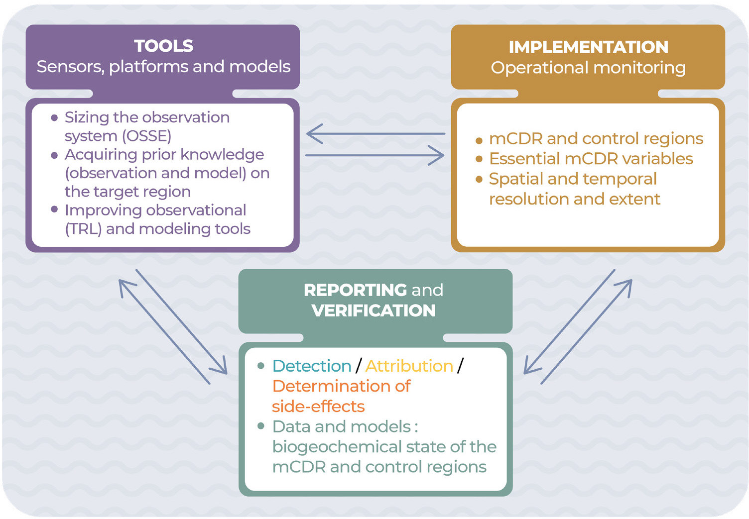
Here, considering information from satellites and autonomous platforms combined with artificial intelligence (AI) and models (Figure 1), we describe a future operational monitoring system for the detection, attribution, and determination of side effects of open-ocean mCDR deployments. We mainly address the monitoring challenge described in NASEM (2022), based upon the current and expected readiness of observational platforms and sensors. This approach ensures that the proposed monitoring system would be tractable and deployable. The assessment of future mCDR deployments will include three components, together referred to as MRV: measurement or monitoring (M) as described in this study, reporting (R) of the resulting data to a certified authority, and verification (V) by this authority, using data and models, that any deployment is successful at increasing CO2 influx from the atmosphere and enhancing its sequestration in the ocean. Successful verification of removal and sequestration will result in certification of the mCDR. The last two MRV components are mentioned in the last section of the study.
|
|
Our study for this “Frontiers in Ocean Observing” supplement of Oceanography focuses on the observational aspects of the monitoring of open-ocean mCDR deployments, with less emphasis on the corresponding, essential modeling components. We nevertheless briefly describe the latter where necessary.
OBJECTIVES OF AN mCDR MONITORING SYSTEM
Monitoring is essential in order to quantify the effectiveness (removal) and durability (sequestration) of carbon storage resulting from open-ocean mCDR deployments and to identify environmental impacts (NASEM, 2022). Here, we examine three objectives of a future open-ocean mCDR monitoring system. Our definitions of detection and attribution are consistent with those in the Glossary of the Intergovernmental Panel on Climate Change (IPCC, 2021).
DETECTION. To quantify the amount of carbon sequestered as DIC. This will require quantification of metrics that document both the amount of carbon removed, based on models that assimilate accurate in situ measurements of carbon system variables, and the durability of its removal (i.e., long-term [decadal] estimates of air-sea CO2 exchanges).
ATTRIBUTION. To assign the detected carbon sequestration solely to a particular mCDR deployment. Attribution requires an understanding of the processes that jointly determine the success or failure of the given mCDR deployment and must thus address the influence of complex drivers in the carbon cycle to demonstrate additionality (see next section). Attribution addresses the proportion of carbon sequestration that can be attributed to an mCDR deployment, even if there are contributions by other drivers within the carbon cycle. This will involve advanced modeling capabilities that simulate the state of the coupled physical and biogeochemical ocean and its modification by the mCDR deployment.
DETERMINATION OF SIDE EFFECTS. To identify and quantify ecological impacts of the mCDR and ensure that they do not exceed the impacts expected from the pilot studies. The mCDR deployments will necessarily modify the ocean, but intended and unintended ecological impacts are poorly known. This will require monitoring ecological variables in at least the upper 1,000 m as well as deeper, including at the seafloor where benthic systems could be affected. Side effects would be assessed through modeling studies of the impacts of biogeochemical changes on marine ecosystems. Unacceptable ecological side effects, acute or chronic, may lead to the termination of an mCDR deployment.
MODEL VALIDATION, EXCLUSION, AND ADDITIONALITY
To achieve these three objectives, model simulations will be run, with and without mCDR. In order to fulfill this role, simulations will have to capture many ongoing changes in the ocean that include those due to climate change, the hysteresis effects from climate change, the effects of other mCDR (and terrestrial CDR), and the effects of emissions reductions on the ocean carbon cycle. It will require advanced modeling capabilities that could effectively simulate the state of the coupled physical and biogeochemical ocean and its changes under the different mCDR scenarios. Such models pose many scientific and technological challenges that impede the development of Digital Twins of the Ocean (DTO). The DTO will combine next-generation ocean modeling, artificial intelligence, and high-performance computing to create digital replicas of the ocean that are regularly informed and improved with observations. Some of the observations will be used in the models, and others will be kept for model validation.
Extensive validation of these models and their improvements (e.g., optimization of model parameters) will be needed well in advance of and during mCDR deployments. Confirming that the simulations are consistent with observations will require the initiation of monitoring a long time before any mCDR deployment. During this pre-deployment period, no mCDR could be undertaken in the mCDR-intended region.
However, there may be cases where model validation could not be undertaken well in advance of the mCDR deployments, for example, where a deployment would take place without prior, long-term consultation with the authority to which monitoring would be reported. In such a case, the results of model simulations run with and without mCDR could be compared with observations made in the mCDR-deployment region and one or more control regions (with long-term time-series observations) where conditions would be comparable to those in the selected mCDR region and where no mCDR of any type would be deployed. Of course, control regions will eventually become “contaminated” by the spread of DIC—via ocean circulation—from mCDR deployed elsewhere (e.g., Boyd and Bressac, 2016), but they could be used for model validation before this occurs and even after.
Failure to implement either pre-deployment periods or control regions would make attribution impossible and therefore compromise the monitoring of all mCDR deployments in a given ocean region. In addition, an open registry or metadatabase of the mCDR pilot studies and deployments would be very useful in this context. It would provide information, in particular for modelers, on the location and depth of each activity and key information on its technical aspects (e.g., for alkalinization, the mineral type, timing, and amount of alkalinity added).
Furthermore, we assume here the desirable exclusion principle, whereby the deployment of one type of mCDR in a given ocean region excludes the possibility of deploying other types there. This principle stems from the likelihood that multiple-type deployments in a given region, especially as mCDR deployments aim to sequester carbon at the gigaton scale,1 would make attribution of individual deployments impossible (Boyd and Bressac, 2016). Exclusion is also important because multiple-type deployments could potentially cause interactive side effects that were not anticipated by single-type mCDR pilot studies.
Pre-deployment periods or control regions—in situ or in models—are also needed to assess the additionality of mCDR deployments, defined in IPCC (2022) as: “The property of being additional. Mitigation is additional if the greenhouse gas emission reductions or removals would not have occurred in the absence of the associated policy intervention or activity.” Thus, additionality is the requirement that the net increase in the air-to-sea CO2 flux due to an mCDR deployment (i.e., based on detection and attribution) exceeds the flux in the absence of this mCDR.
Monitoring for additionality will be especially challenging as the change in net carbon flux into the ocean and the magnitude of carbon sequestration caused by an mCDR deployment will be very small compared to natural air-sea carbon fluxes and the magnitude of the ocean carbon sink. In addition, the models will need to take into account the inherent uncertainties of field measurements. This will pose challenges for both observation and modeling.
1 The intended gigaton-scale magnitude of mCDR deployments would be much larger than existing multiple overlapping uses and perturbations. For example, global marine capture fisheries and aquaculture harvested 112 Mt of animals and 36 Mt of seaweeds (fresh weight) in marine waters in 2020 (FAO, 2022), which represented ~0.02 GtC yr–1.
GENERAL REQUIREMENTS FOR AN mCDR MONITORING SYSTEM
Guidelines for monitoring were set for the Global Ocean Observing system (GOOS) in the context of the Framework for Ocean Observation (FOO; Tanhua et al., 2019). A key element of the FOO is its organization and coordination around essential ocean variables (EOVs) rather than specific observing systems. The mCDR operational system described here differs from the GOOS observations, but also focuses on EOVs.
We advocate that “essential mCDR variables” would include most current EOVs (see GOOS, 2021), along with more detailed data on lower atmosphere CO2 concentration and oceanic DIC used to estimate air-sea CO2 flux. Variables would also include wind speed, which has a strong influence on air-sea gas exchange.
The effects of mCDR deployments on carbon capture and sequestration will accumulate over time. Consequently, meeting the three objectives discussed above will require long-term monitoring.
Given the remote nature and carbon-sequestration target of open-ocean mCDR deployments, monitoring their effects will require systems with at least the following characteristics to efficiently address the objectives of detection, attribution, and determination of side effects:
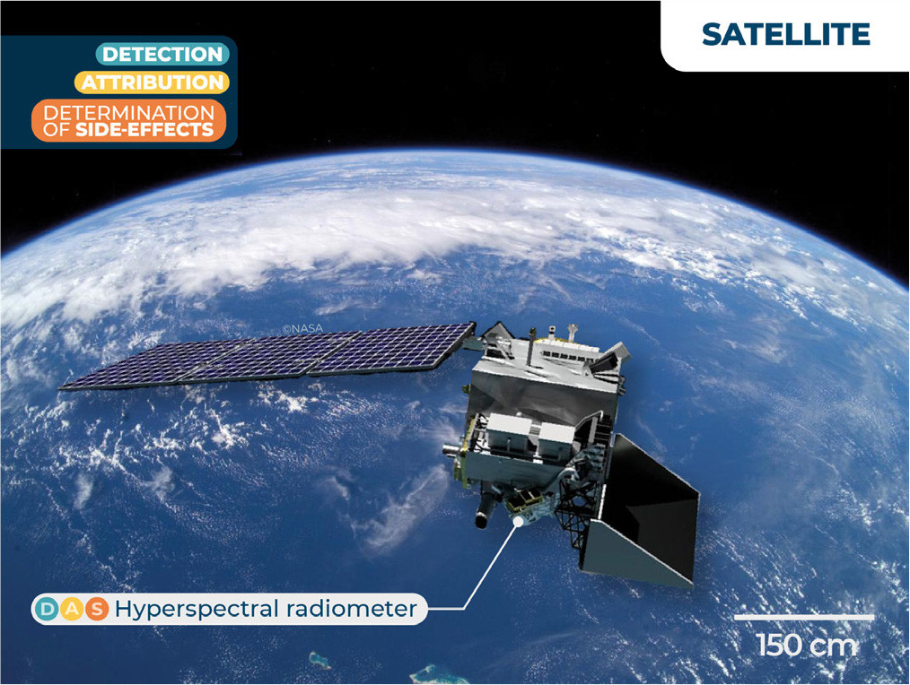
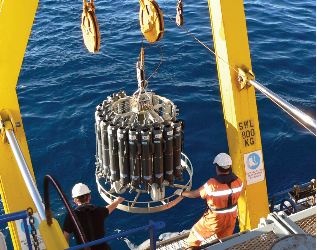
- Calibrated sensors on autonomous platforms, that is, satellites (Figure 2) and in situ robots (see Box 1)
- Sampling over large surface areas to address horizontal eddy diffusion and transport
- Recurrent long-term measurements, commensurate with the duration of mCDR deployments
- Quasi-simultaneous estimates of air-sea CO2 exchange and concentrations of DIC, particulate inorganic carbon (PIC), DOC, and POC from surface to depth to monitor the fate of the additional carbon
|
|
Air-sea CO2 flux cannot be measured directly over large areas; it would be estimated by modeling. To do so, at least two parameters of the carbonate system should be measured in the water column. These parameters include pH, total DIC, total alkalinity (TA), and CO2 partial pressure (pCO2). Detecting changes in the carbonate system is challenging, and detecting a superimposed mCDR effect would be very difficult.
The monitoring system would combine satellite remote sensing (Figure 2) and long-term regional in situ measurements. The latter would be performed with autonomous robots (see Box 1), as described by Chai et al. (2020). Biogeochemical data would subsequently be analyzed using AI and assimilated in models. The integration of these platforms, analyzing their data with AI, and combining the data with models is already partly implemented in open-ocean research (e.g., Claustre et al., 2021) and could be readily applicable to monitor open-ocean mCDR deployments.
|
|
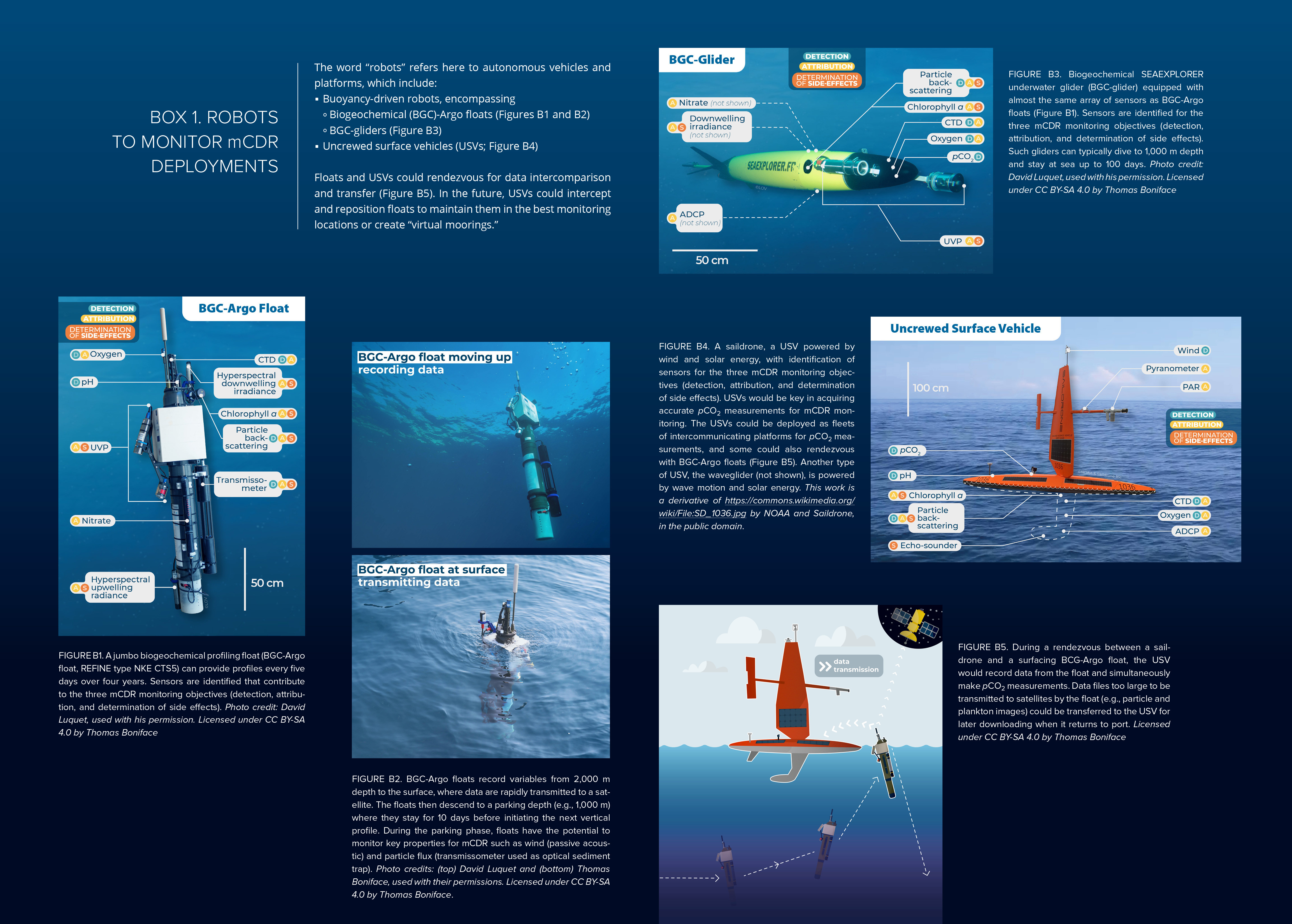
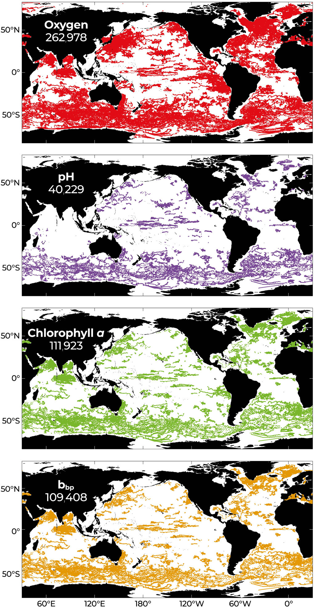
Ideally, the observational and modeling components of the mCDR monitoring system should be in place prior to an mCDR deployment. If this is impossible, data collected by the global networks of Biogeochemical-Argo (BGC-Argo) floats (Figure 3) and ocean color satellites (Figure 2) could document natural variability and contribute to the validation/calibration of models required for attribution.
|
|
COMPONENTS OF AN mCDR MONITORING SYSTEM
Satellites and underwater robots operate autonomously, making relatively high-frequency measurements over several years. Present-day BGC-Argo floats (Figure B1) can achieve 300 profiles of up to 13 different variables2 during their lifetimes, for example, profiling every five days over four years. Horizontally, satellites (Figure 2) cover large surfaces (with a spatial resolution of up to 4 × 4 km), and floats can be operated as fleets with strong interoperability of measurements (Figure 3). Vertically, remote sensing investigates the ocean skin (the upper 10–100 μ) for some variables (e.g., temperature) and deeper waters for others (e.g., ocean color), whereas BGC-Argo floats and BGC-gliders make measurements from the surface, including the ocean-atmosphere interface, to 2,000 m depth (Figures B2 and B3).
2 Temperature, salinity, dissolved O2, pH, dissolved NO3, chlorophyll a, particulate backscattering coefficient (bbp), colored dissolved organic matter (CDOM), downwelling irradiance, upwelling radiance, particle size spectra, particles and plankton 100–2,00 µm, optical sediment trap (transmissometer).
DESIGNING AN mCDR MONITORING SYSTEM
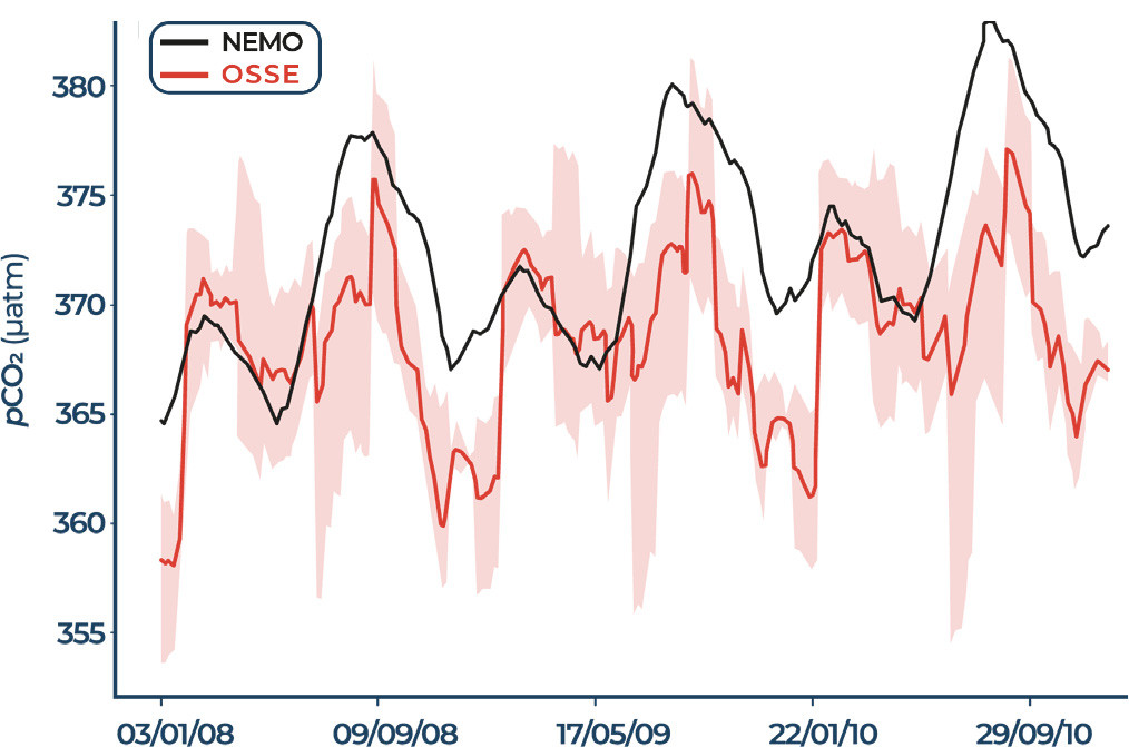
Observation System Simulation Experiments (OSSEs) would be used to design the observing system required for the three objectives of mCDR monitoring: detection, attribution, and determination of side effects. OSSEs are powerful tools that provide quantitative assessments of the impacts of observations combined with models to reconstruct the coupled physical and biogeochemical state of the ocean (Figure 4). Using OSSEs, observing systems could be designed to fit the characteristics of long-term mCDR deployments. The observations to be considered in these OSSEs include those from the fundamental GOOS system (satellite and in situ; Figures 2 and 5) and specific new observations in the mCDR regions. Developing such OSSEs is challenging and will require advanced modeling capabilities.
|
|
|
|
A successful mCDR deployment would shift the perturbed ocean region from its pre-mCDR trajectory to a different, new mCDR trajectory with enhanced carbon sequestration. Measurements prior to mCDR deployments and during the transition period would be especially useful for detection and attribution, and would help identify any initial acute ecological side effects. Measurements during the ongoing mCDR deployment would be used for long-term detection and attribution, and to identify further ecological effects. Based on present-day observational limitations (e.g., pH is the only variable of the carbonate system measured on BGC-Argo floats; Figure B1) in relation to the anticipated magnitude of mCDR from model projections (Keller et al., 2014), detection, attribution, and detection of side effects will require rapid advances in sensor technology.
MONITORING mCDR DEPLOYMENTS
The monitoring and evaluation of mCDR deployments would use satellites as well as surface and underwater robots to make the following measurements:
DETECTION. To assess the effectiveness of an mCDR deployment in sequestering CO2, changes in concentrations of DIC, PIC, TA, DOC, and POC and particle downward fluxes should be measured over the water column based on the design derived from OSSEs. These observations will be used to reconstruct the ocean carbon state together with models (data assimilation). Running OSSEs (with and without mCDR) will also provide ocean carbon state reconstruction errors and the duration of the monitoring required to allow separation of noise from signal. Sensors already exist, or are being developed, for most of these variables. In addition to pH already measured by robots, there are ongoing efforts to adapt sensors to autonomous platforms that measure at least one other parameter of the carbonate system (i.e., TA or pCO2) to calculate DIC or the air-sea CO2 flux (Bushinsky et al., 2019). Estimating accurate ocean-atmosphere CO2 fluxes also requires wind speed, particularly during storms. These values can be derived from BGC-Argo float or BCG-glider passive acoustic measurements, which should be systematically deployed.
ATTRIBUTION. To understand and deconvolve the processes involved in the cumulative outcome of an mCDR deployment, measurements similar to those used for ocean biological carbon pump studies (e.g., Claustre et al., 2021) would be used. Variables required to validate and run models would likely include environmental forcing (hydrodynamics, light, nutrients), carbon-related processes (net community production, organic matter remineralization), and resulting chemical changes (e.g., DIC and O2).
DETERMINATION OF SIDE EFFECTS. To assess the ecological impacts of an mCDR deployment, both satellite and in situ optical measurements would provide information on changes in plankton size structure and composition. Images and active acoustic-based sensors would provide information on zooplankton and small pelagic organisms (Claustre et al., 2021). In the case of mCDR deployments that purposefully alter the assemblage of suspended particles (e.g., alkalinization), changes in underwater irradiance and associated effects on photosynthesis would also be monitored in situ and remotely, for example, through hyperspectral radiometric measurements.
GOVERNANCE OF AN mCDR MONITORING SYSTEM
Published mCDR studies have mostly considered research aspects for future deployments as explained in the Introduction. Our study represents a departure from these studies as it details an operational system designed to monitor large-scale open-ocean mCDR deployments. For verification to be credible, the monitoring system and the interpretation of measurements in terms of sequestration efficiency must be performed independently of the entities deploying mCDRs. In addition, all monitoring data should promote the FAIR principles of findability, accessibility, interoperability, and reuse.
Meeting these operational characteristics will require governance and best practices fundamentally different from those of curiosity-driven or targeted research (Chapter 9 of NASEM, 2022). Robust governance would be required to implement the following constraints, without which mCDR could not be effectively deployed:
- Confirmation that the principle of additionality is fulfilled, and assessment of evidence of the effectiveness of mCDR in sequestering CO2 (detection)
- Implementation of pre-deployment periods or control regions (attribution)
- Implementation of the exclusion principle (i.e., excluding additional mCDR types—and their confounding influences—from any region where there is an ongoing type of mCDR deployment (attribution)
- Assessment of the degree of ecological side effects to decide if their severity should lead to termination of the mCDR deployment (determination of side effects)
Strong governance will be required, as it is highly likely that if a license is granted for a particular mCDR method, then subsequent permissions will be granted for other promising mCDR methods. This is in addition to coastal blue carbon and terrestrial CDR approaches. Achieving efficient monitoring entails two deployment constraints described above: the setting of pre-deployment periods (during which no mCDR could be undertaken in the mCDR-intended region) or control regions (where no mCDR of any type would be deployed), and the exclusion principle whereby the deployment of one type of mCDR in a given ocean region excludes the possibility of deploying other types there. The implementation and effective enforcement of these two constraints would require an ocean governance framework that does not presently exist.
What could be the role(s) of the ocean research community in monitoring forthcoming mCDR deployments? First, prepare plans for mCDR monitoring systems, as outlined above, and contribute to defining governance and best practices of mCDR monitoring. Second, train the scientists and engineers who will run the mCDR monitoring systems and analyze/model the resulting information. Third, contribute to the multi-faceted education of the scientific and other personnel who will staff the oversight authorities for mCDR deployments. Fourth, act as advisors to and watchdogs for the mCDR deployment entities and authorities as knowledge on the influence of mCDR deployments on ocean processes advances.
Until now, the research community has studied the ocean as if it were a pristine environment, despite anthropogenic changes due to factors such as ongoing CO2 pollution and industrial fishing. With mCDR deployments, this illusion would be dispelled, and we would be faced with a new ocean reality. In order to be ready for (near) future open-ocean mCDR deployments, the entire oceanographic community should investigate without delay the desired characteristics and likely challenges of the operational system(s) needed to monitor a profoundly modified ocean.