Full Text
The Challenge: Planning and then Monitoring Marine Protected Areas in Remote Locations
Given the United Nations’ ambitious goal—endorsed by more than 100 nations, including Canada—of protecting 30% of the world’s marine ecosystems by 2030 (UN, 2023), the need to establish, expand, and track the effectiveness of protected areas is becoming more pressing each year. Effective planning for and monitoring of marine protected areas (MPAs) rely on the availability of quality baseline ecological and oceanographic information. Many of the sites in the Canadian Pacific Ocean best suited for protection, due to the confluence of ecological, cultural, and political significance, are remote. This poses two challenges: (1) there is little baseline information to guide planning, and (2) they are challenging to monitor once established.
The Tool: Ocean Gliders
Autonomous sampling technologies, such as ocean gliders and floats, are providing new opportunities to collect oceanographic and ecological information more frequently, at times of year not typically sampled, and in remote regions. These autonomous platforms can sample in harsher conditions, are less costly to operate, and have much lower carbon footprints than ship-based operations.
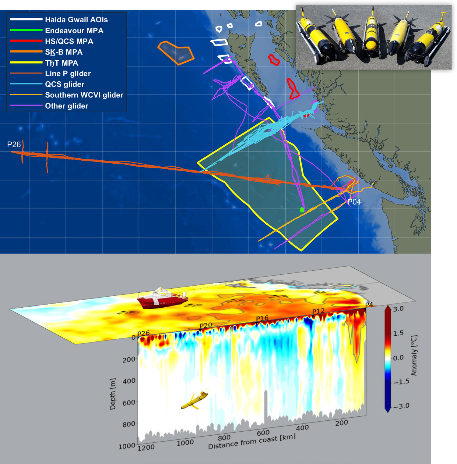
The Canadian-Pacific Robotic Ocean Observing Facility (C-PROOF) has been collecting glider data in understudied areas of interest to inform marine conservation efforts in the Canadian Pacific since 2019 as part of its mission to create a world-class autonomous ocean-observing facility in the Northeast Pacific Ocean and adjacent Canadian coastal waters. C-PROOF is a partnership involving the Universities of Victoria and British Columbia, Fisheries and Oceans Canada, and the Hakai Institute, a not-for-profit organization committed to long-term ecological research on the British Columbian coast. In addition to making an important contribution to regional ocean observing in the Northeast Pacific (Barth et al., 2019), the C-PROOF glider lines pass through or near many remote MPAs in the Canadian Pacific (Figure 1). Ocean gliders traverse these lines at high spatiotemporal resolution in all seasons, gathering comprehensive physical and biogeochemical oceanographic data that provide invaluable insights into the health and dynamics of these marine ecosystems.
|
|
The Successes: First, Regular, and Timely
C-PROOF glider data have successfully contributed to MPA planning and monitoring in three main ways: (1) providing the first baseline oceanographic data in some proposed MPAs, (2) frequent monitoring of oceanographic and ecological variables, including ecosystem stressors (such as ocean acidification and deoxygenation), in remote MPAs, and (3) delivering this oceanographic and ecological context in near-real time, key to tracking marine heatwaves.
Baselines for Proposed MPAs. Even regions of high ecological importance, such as the generation site for Haida eddies that connect the coastal margins to the deep Northeast Pacific, have only been visited about a dozen times by oceanographic expeditions. An MPA planning process is now underway for seven sites along the west and north coasts of Haida Gwaii (white outlines, Figure 1), and five C-PROOF glider missions over the last three years have sampled the sites. The data collected have been incorporated into the official governmental planning process, with a recommendation for repeat glider surveys as part of the eventual monitoring plan (DFO, 2024).
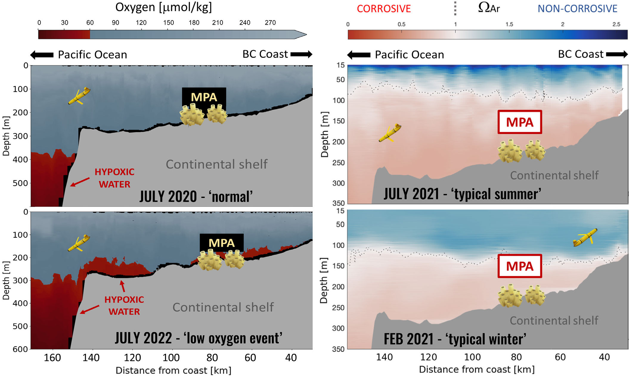
Monitoring in Remote MPAs. All C-PROOF regularly sampled glider monitoring lines pass through or near already designated protected areas. Providing ecosystem stressor data has required extensive quality control of the glider oxygen data and the development and verification of two regionally tuned multiple linear regression models to provide ocean acidification metrics useful to MPA management (e.g., Queen Charlotte Sound: Hare et al., 2023; Line P: Dosser et al., 2024). However, for effective uptake in MPA management, the results must be further refined and simplified to effectively communicate with non-scientist management team members (e.g., Figure 2). With respect to marine heatwaves, intuitive visualizations that merge satellite and glider data (inset in Figure 1) have been instrumental in communicating the importance of looking beneath the surface; deep marine heatwaves last longer and have greater impacts on marine ecosystems than heatwave events confined to the surface (Fragkopoulou et al., 2023).
|
|
Providing Near-Real Time Context. The value of ocean gliders’ capacity to provide oceanographic context in near-real time to serve MPA management needs is exemplified by the ability to adaptively redirect gliders to identify and map extreme events. In the summer of 2021, an unusually large deoxygenation event occurred in the bottom waters on the continental shelf along the west coast of Vancouver Island (Ross et al., 2022). A C-PROOF glider monitoring mission in October 2021 detected this event, and the glider sampling strategy was adapted on-the-fly to better map the event’s evolution. This event was proximate to several existing and proposed MPA sites, and its mapping by adaptive glider sampling illustrates how glider-based monitoring of low oxygen water could provide early warnings of potentially lethal low-oxygen events propagating into an MPA.
In sum, ocean gliders hold significant promise to become key tools in MPA managers’ toolboxes, providing important oceanographic and ecological data critical to understanding and protecting valuable marine ecosystems in a timely and cost-effective manner.


