Oceanography The Official Magazine of
The Oceanography Society
Volume 36 Issue 2–3

View Issue TOC
Volume 36, No. 2–3
Pages 212 - 215

OpenAccess

SPOTLIGHT • MAPR: PMEL’s Miniature Autonomous Plume Recorder

By Sharon L. Walker  
Jump to
Full text Citation References Copyright & Usage
Full Text

The NOAA Vents program was established in 1983 at the Pacific Marine Environmental Laboratory (PMEL; Hammond et al., 2015), just six years after the discovery of hydrothermal vents and their unique chemosynthetic ecosystems (Corliss et al., 1979). Because seafloor hydrothermal venting contributes significantly to the transfer of heat and mass from the solid Earth to the ocean, the program’s mission was to systematically explore, discover, and characterize the environmental impacts of submarine volcanism and hydrothermal venting on ocean physical, chemical, and biological processes. The program initially focused on the mid-ocean spreading centers in PMEL’s “backyard” (i.e., the Gorda, Juan de Fuca, and Endeavour Ridges in the Northeast Pacific) where segment-scale surveys detected plumes in the water column above the ridge crest that led to the discovery of numerous individual vent fields (see Hammond et al., 2015, and references therein). New technologies and techniques were created and/or adapted to address the challenges of finding and studying these vents. Repeat visits to the Northeast Pacific sites documented spatial and temporal changes, stimulating the development of new hypotheses about their associated biogeochemical processes. However, testing how broadly applicable these hypotheses would be on a global scale required discovering new vent sites from a far wider range of geological settings, and global-​scale exploration requires significant resources.


MAPR deployed above a pump was used to verify that high-volume filtration for radon samples occurred within a hydrothermal plume. > High res figure


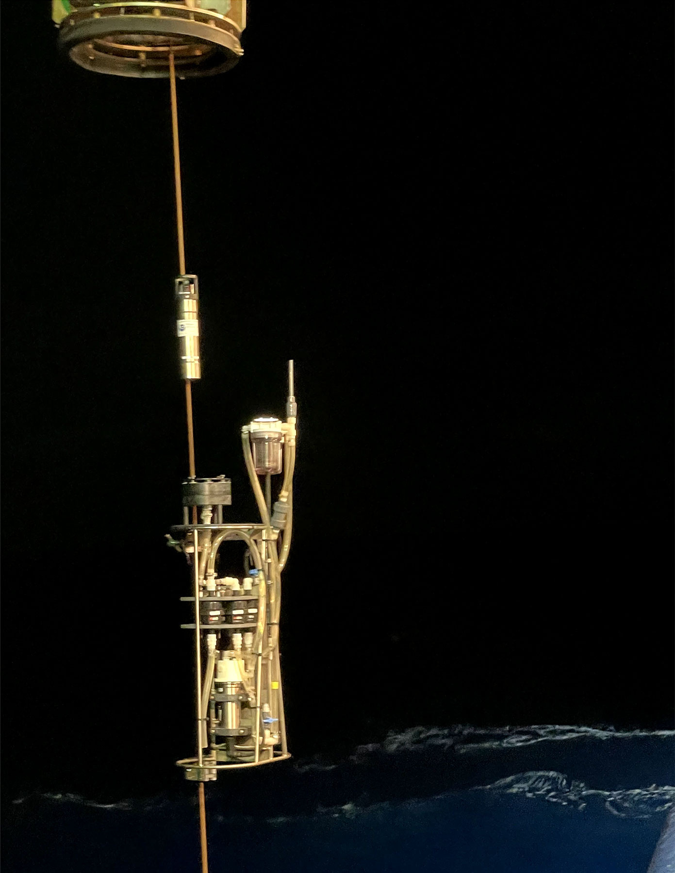
The term “crowdsourcing” was not part of our collective vocabulary in 1995, but Vents program Principal Investigator Edward Baker envisioned doing just that by engaging the broader US and international community as collaborators in global exploration and data acquisition. He and other Vents program scientists teamed up with PMEL engineers to develop the Miniature Autonomous Plume Recorder (MAPR, Figure 1): a small, self-contained, easy-to-use instrument with sensors specific for detecting hydrothermal plumes that could be deployed, without dedicated technicians, on a variety of operations where wires lowered to the seafloor did not already have sensors to measure water column properties (e.g., wax corers, dredges, geophysical and seabed imaging systems). Additionally, with the discovery that seafloor volcanic eruptions generated “megaplumes” (Baker et al., 1987) with distinct physical and chemical characteristics, it was intended that MAPRs could be an easily mobilized observation tool for event response.


FIGURE 1. Miniature Autonomous Plume Recorder (MAPR) instruments. (a) Original design (1995) with integrated temperature and pressure, but external optical backscatter sensor. (b) Current MAPR design with temperature, pressure, optical backscatter (since 2001), and oxidation-​reduction potential sensors (since 2005) all integrated in the top end cap, protected by the sensor shield (shown off to the side for better view of the sensors). > High res figure


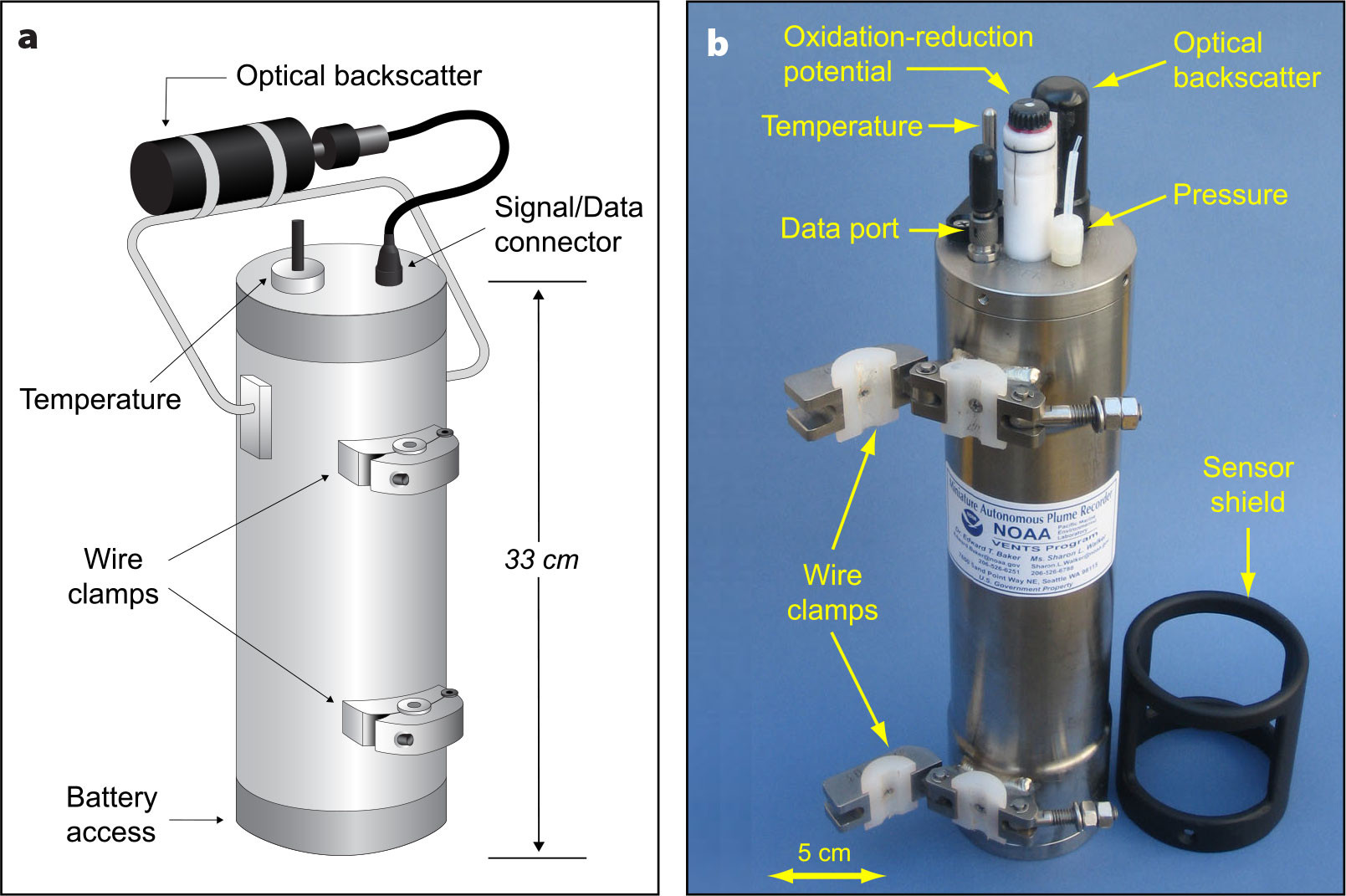
Originally, MAPRs included sensors for temperature, pressure, and optical backscatter, which provided data effective for detecting plumes enriched in hydrothermal particles such as those typically generated at high-temperature black smoker vents (Baker and Milburn, 1997). However, as new vent sites were discovered globally, in every ocean basin (e.g., Beaulieu et al., 2013) and from pole to pole (German et al., 2000; Baker et al., 2004), the diversity of vent sites became apparent, and the importance of exploring for low-temperature and particle-​poor vent sites increased. To address this challenge, oxidation-reduction potential (ORP) sensors were added to MAPRs in 2005 (Walker et al., 2007). ORP is highly sensitive to dissolved reduced chemical species common in hydrothermal plumes (i.e., Fe2+, H2, HS, Mn2+) even when particles are absent. An added benefit is that the ORP signal is more spatially limited than particle plumes due to the relatively rapid oxidation of the reduced species, which helps narrow the search area for source locations on the seafloor and improve spatial resolution of distinct discharge sites where overlying particle plumes may coalesce (Baker et al., 2016).

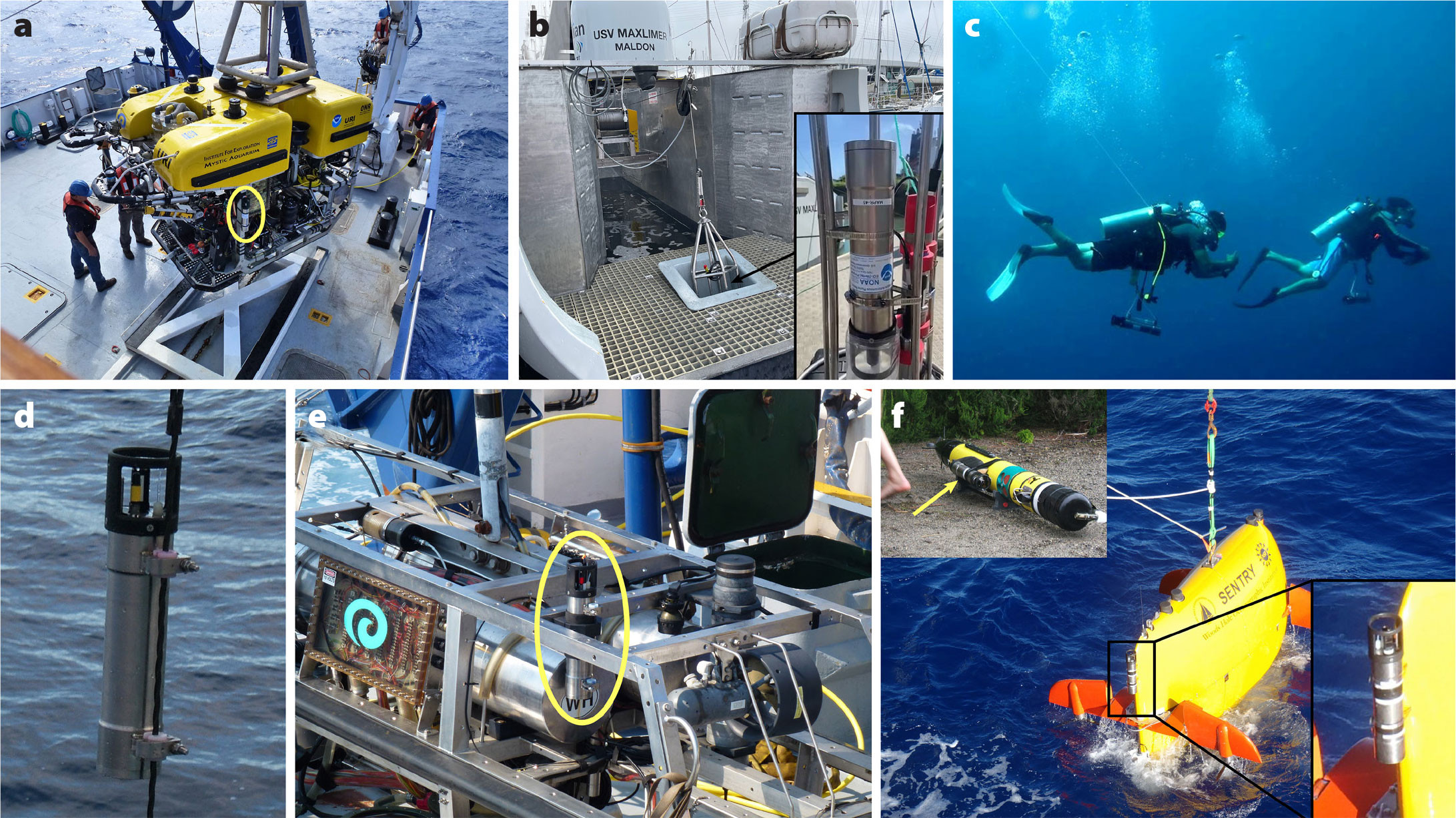
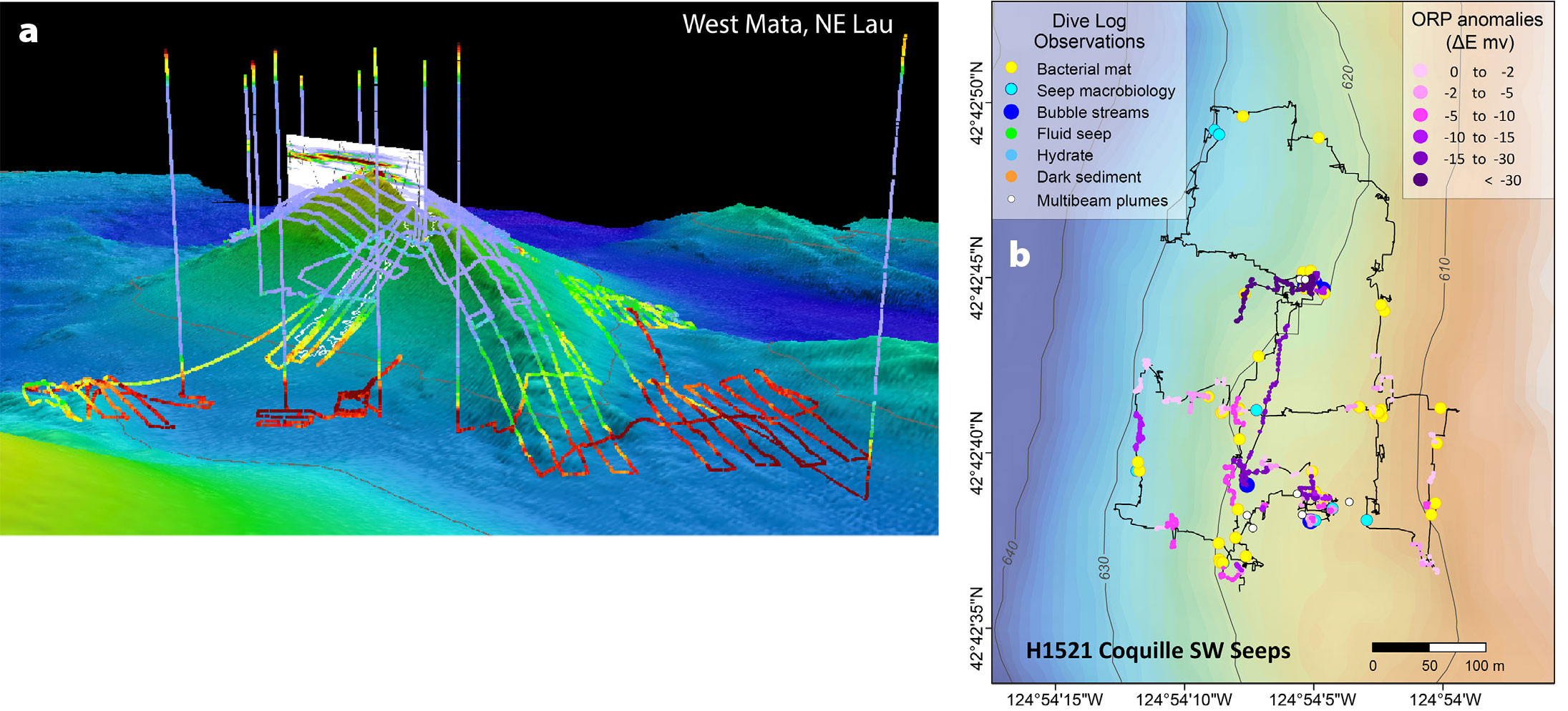
Development of the ORP sensor for MAPR instruments led to the creation of a stand-alone ORP sensor that was suitable for use as an auxiliary sensor on a standard CTD. This sensor was also designed and constructed by the PMEL engineering team. The PMEL MAPR program currently supports a fleet of 35 MAPR instruments and eight ORP sensors available for collaborative use by a wide range of academic, governmental, and commercial researchers. In addition to deploying MAPRs on dredges, wax corers, and towed geophysical observation systems, it has become common to attach them to autonomous underwater vehicles (AUVs), remotely operated vehicles (ROVs), and even scuba divers as they survey near-shore hydrothermal fields (Figure 2). In addition to being a valuable tool for global deep-sea hydrothermal exploration, MAPR instruments have been used to map far-field ash distributions from submarine volcanic eruptions (Figure 3a; Walker et al., 2019), define areas of hydrothermal discharge in volcanic lakes (Walker et al., 2016), monitor seasonal turbidity and deposition in an alpine lake (Roop et al., 2015; Levy et al., 2018), and for mapping the extent of methane seep sites (Figure 3b; Walker et al., 2018).


FIGURE 2. Versatility, robustness, and reliability are key criteria for MAPR design. Images here show several platforms on which MAPRs have been deployed: (a) attached to remotely operated vehicle (ROV) Hercules (Ocean Exploration Trust); (b) mounted on a custom cage and winch (seen in background) used to deploy MAPRs through the transom of uncrewed surface vehicle Maxlimer (Sea-Kit International) for event response to the Hunga volcano eruption of January 2022, Kingdom of Tonga (inset shows MAPR mounted in cage); (c) attached to scuba harnesses for survey over a shallow, nearshore vent site (photo credit: Brennan Phillips); (d) attached to a wire; (e) mounted on the frame of a towed system; (f) attached to large and small autonomous underwater vehicles (AUVs) (upper left insert: on a REMUS-100 AUV; center: on the Woods Hole Oceanographic Institution AUV Sentry; lower left: detail of MAPR attached to AUV Sentry). > High res figure


The Vents program evolved into the Earth-Ocean Interactions (EOI) program in 2014. EOI staff remains located in both Seattle, Washington, and Newport, Oregon, PMEL offices, with continuing participation by oceanographers, chemists, and geologists from cooperative institutes at the University of Washington and Oregon State University. By 2016, the scope of research expanded to include additional seafloor phenomena and processes that impact ocean biogeochemical cycles (Butterfield et al., 2023, in this issue). For example, over 3,500 methane seep bubble plumes, clustered into 1,300 individual sites, have been identified along the Cascadia margin between the Strait of Juan de Fuca (offshore Washington state) and the Mendocino Fracture Zone (offshore northern California; Merle et al., 2021). Several of these sites have been the focus of ROV dives to characterize the gases, fluids, substrate, and biology at the seeps (Baumberger et al., 2018; Seabrook et al., 2018). MAPRs mounted on the ROV during these dives confirmed fluid flow extended beyond visually identified bubble emissions, and was correlated with observations of chemosynthetic bacterial mats, clams, stained sediments, and other seep indicators, despite no visually identifiable flow noted in the dive logs (Figure 3b; Walker et al., 2018).


FIGURE 3. MAPR results show (a) a deep ash plume dispersing from a recent eruption at West Mata submarine volcano, NE Lau, mapped during AUV Sentry surveys (Walker et al., 2019), and (b) near-​bottom oxidation-​reduction potential (ORP) anomalies at a methane seep site explored with ROV Hercules (Walker et al., 2018). > High res figure


Ease-of-use and versatility have been defining characteristics of MAPR instruments since their inception. Originally viewed as something to attach to wires or towed platform frames, new and innovative deployment opportunities continually arise. Most recently, MAPRs were rapidly mobilized in response to the massively powerful Hunga volcano (Tonga) eruption of January 15, 2022. They were easily added to a custom-built cage that was deployed from a winch on the uncrewed surface vessel Maxlimer (Sea-Kit International). The vessel was sent to the Kingdom of Tonga to map the dramatically changed seafloor and investigate the status of ongoing volcanic and/or hydrothermal activity within the deep caldera/explosion crater formed during the event (Walker et al., 2022). The mission was operated entirely remotely from over 16,000 km away, with only two engineers located in Tonga to handle all aspects of vessel setup, maintenance, and liaising with local officials for necessary clearances, permits, and operational issues. Managing MAPR setup and data retrieval added very little time to their numerous other responsibilities.

Currently, the MAPR program provides equipment and support for 10–15 collaborative projects each year with US and international partners. The physical design has proven to be extremely durable and robust, with little need for modifications. However, thanks to new electronic capabilities and the expiring lifetimes of existing components, a significant redesign of internal electronics and software is currently underway. The next generation of MAPRs will have increased capabilities including faster sample rates, real-time data monitoring (i.e., during ROV dives), better power management for longer deployments, the potential to accommodate additional or different sensors, and easier, faster data downloads. We look forward to supporting new and innovative applications of this reliable ocean observation system in the years to come.


Acknowledgments

Many individuals have contributed to the success of the MAPR program. We would especially like to thank Edward Baker and Hugh Milburn for conceiving and designing the original MAPR instruments. Sincere thanks go to PMEL engineers Christian Meinig, Patrick McLain, Dirk Tagawa, Scott Stalin, Dennis Holzer, John Shanley, Noah Lawrence-Slavas, Randy Bott, and Ryan Wells for their excellent support. Ko-ichi Nakamura (AIST, Japan) contributed to the development of ORP sensors. This is PMEL contribution number 5946.
Citation

Walker, S.L. 2023. MAPR: PMEL’s Miniature Autonomous Plume Recorder. Oceanography 36(2–3):212–215, https://doi.org/​10.5670/oceanog.2023.220.

References

Baker, E.T., G.J. Massoth, and R.A. Feely. 1987. Cataclysmic hydrothermal venting on the Juan de Fuca Ridge. Nature 329:149–151, https://doi.org/​10.1038/329149a0.

Baker, E.T., and H.B. Milburn. 1997. MAPR: A new instrument for hydrothermal plume mapping. RIDGE Events 8(1):23–25.

Baker, E.T., H.N. Edmonds, P.J. Michael, W. Bach, H.J.B. Dick, J.E. Snow, S.L. Walker, N.R. Banerjee, and C.H. Langmuir. 2004. Hydrothermal venting in magma deserts: The ultraslow-spreading Gakkel and Southwest Indian Ridges. Geochemistry, Geophysics, Geosystems 5(8), https://doi.org/​10.1029/2004GC000712.

Baker, E.T., J.A. Resing, R.M. Haymon, V. Tunnicliffe, J.W. Lavelle, F. Martinez, V. Ferrini, S.L. Walker, and K. Nakamura. 2016. How many vent fields? New estimates of vent field populations on ocean ridges from precise mapping of hydrothermal discharge locations. Earth and Planetary Science Letters 449:186–196, https://doi.org/10.1016/​j.epsl.2016.05.031.

Baumberger, T., R.W. Embley, S.G. Merle, M.D. Lilley, N.A. Raineault, and J.E. Lupton. 2018. Mantle-derived helium and multiple methane sources in gas bubbles of cold seeps along the Cascadia Continental Margin. Geochemistry, Geophysics, Geosystems 19(11):4,476–4,486, https://doi.org/​10.1029/2018GC007859.

Beaulieu, S.E., E.T. Baker, C.R. German, and A. Maffei. 2013. An authoritative global database for active submarine hydrothermal vent fields. Geochemistry, Geophysics, Geosystems 14(11):4,892–4,905, https://doi.org/10.1002/2013GC004998.

Butterfield, D.A., S.L. Walker, T. Baumberger, J. Beeson, J. Resing, S.G. Merle, A. Antriasian, K. Roe, G.-S. Lu, P. Barrett, and W.W. Chadwick Jr. 2023. The PMEL Earth-Ocean Interactions Program: Beyond vents. Oceanography 36(2–3):206–211, https://doi.org/10.5670/oceanog.2023.229.

Corliss, J.B., J. Dymond, L.I. Gordon, J.M. Edmond, R.P. von Herzen, R.D. Ballard, K. Green, D. Williams, A. Bainbridge, K. Crane, and T.H. van Andel. 1979. Submarine thermal springs on the Galapagos Rift. Science 203:1,073–1,083, https://doi.org/10.1126/science.203.4385.1073.

German, C.R., R.A. Livermore, E.T. Baker, N.I. Bruguier, D.P. Connelly, A.P. Cunningham, P. Morris, I.P. Rouse, P.J. Stratham, and P.A. Tyler. 2000. Hydrothermal plumes above the East Scotia Ridge: An isolated high-latitude back-arc spreading centre. Earth and Planetary Science Letters 184:241–250, https://doi.org/10.1016/S0012-821X(00)00319-8.

Hammond, S.R., R.E. Embley, and E.T. Baker. 2015. The NOAA Vents Program 1983 to 2013: Thirty years of ocean exploration and research. Oceanography 28(1):160–173, https://doi.org/​10.5670/oceanog.2015.17.

Levy, R.H., G.B. Dunbar, M.J. Vandergoes, J.D. Howarth, T. Kingan, A.R. Pyne, G. Brotherston, M. Clarke, B. Dagg, M. Hill, and others. 2018. A high-resolution climate record spanning the past 17,000 years recovered from Lake Ohau, South Island, New Zealand. Scientific Drilling 24:41–50, https://doi.org/10.5194/sd-24-41-2018.

Merle, S.G., R.W. Embley, H.P. Johnson, T.-K. Lau, B.J. Phrampus, N.A. Raineault, and L.J. Gee. 2021. Distribution of methane plumes on Cascadia Margin and implications for the landward limit of methane hydrate stability. Frontiers in Earth Science 9:531714, https://doi.org/10.3389/feart.2021.531714.

Roop, H.A., G.B. Dunbar, R. Levy, M.J. Vandergoes, A.L Forrest, S.L. Walker, J. Purdie, P. Upton, and J. Whinney. 2015. Seasonal controls on sediment transport and deposition in Lake Ohau, South Island, New Zealand: Implications for a high-​resolution Holocene paleoclimate reconstruction. Sedimentology 62(3):826–844, https://doi.org/​10.1111/sed.12162.

Seabrook, S., F.C. De Leo, T. Baumberger, N. Raineault, and A.R. Thurber. 2018. Heterogeneity of methane seep biomes in the northeast Pacific. Deep Sea Research Part II 150:195–209, https://doi.org/10.1016/j.dsr2.2017.10.016.

Walker, S.L., E.T. Baker, J.A. Resing, K-I. Nakamura, and P.D. McLain. 2007. A new tool for detecting hydrothermal plumes: An ORP sensor for the PMEL MAPR. Abstract V21D-0753 presented at 2007 Fall Meeting, American Geophysical Union, December 10–14, San Francisco, CA.

Walker, S.L., C.E.J. de Ronde, D. Fornari, M.A. Tivey, and V.K. Stucker. 2016. High-resolution water column survey to identify active sublacustrine hydrothermal discharge zones within Lake Rotomahana, North Island, New Zealand. Journal of Volcanology and Geothermal Research 314:142–155, https://doi.org/​10.1016/j.jvolgeores.2015.07.037.

Walker, S.L., T. Baumberger, S.G. Merle, and R.W. Embley. 2018. The near-bottom distribution of ORP anomalies at methane seeps along the U.S. Cascadia continental margin. Abstract BN24C-1103 presented at 2018 Ocean Sciences Meeting, February 11–16, Portland, OR.

Walker, S.L., E.T. Baker, J.E. Lupton, and J.A. Resing. 2019. Patterns of fine ash dispersal related to volcanic activity at West Mata volcano, NE Lau basin. Frontiers in Marine Science 6:593, https://doi.org/​10.3389/fmars.2019.00593.

Walker, S.L., C.E.J. de Ronde, M. Williams, K. Zwolak, B. Simpson, and TESMaP Team. 2022. Ongoing activity within the submarine caldera of Hunga Tonga-Hunga Ha’apai volcano, Tonga, six months after the eruption of January 15, 2022. Abstract V16A-02 presented at 2022 Fall Meeting, American Geophysical Union, December 12–16, Chicago, IL.

Copyright & Usage

This is an open access article made available under the terms of the Creative Commons Attribution 4.0 International License (https://creativecommons.org/licenses/by/4.0/), which permits use, sharing, adaptation, distribution, and reproduction in any medium or format as long as users cite the materials appropriately, provide a link to the Creative Commons license, and indicate the changes that were made to the original content. Images, animations, videos, or other third-party material used in articles are included in the Creative Commons license unless indicated otherwise in a credit line to the material. If the material is not included in the article’s Creative Commons license, users will need to obtain permission directly from the license holder to reproduce the material.