Oceanography The Official Magazine of
The Oceanography Society
Volume 10 Issue 02

View Issue TOC
Volume 10, No. 2
Pages 49 - 52

OpenAccess

Mapping Surface Currents in Monterey Bay With CODAR-Type HF Radar

By Jeffrey D. Paduan  and Michael S. Cook 
Jump to
Citation Copyright & Usage
First Paragraph

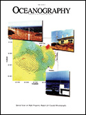
High-frequency (HF) radar measurements have been employed around Monterey Bay, CA, to measure ocean surface currents since February 1992. The first array consisted of two older-generation CODAR instruments located at sites near Monterey in the south and Moss Landing, halfway around the bay to the north (Front Cover: Fig. 1). In 1994, the southern site was replaced with a newer-generation SeaSonde system at Pt. Pinos and a similar unit was installed near Santa Cruz on the northern shore of Monterey Bay. Finally, in 1996, the CODAR system in Moss Landing was replaced by a modern SeaSonde unit.

Citation

Paduan, J.D., and M.S. Cook. 1997. Mapping surface currents in Monterey Bay with CODAR-type HF radar. Oceanography 10(2):49–52, https://doi.org/10.5670/oceanog.1997.21.

Copyright & Usage

This is an open access article made available under the terms of the Creative Commons Attribution 4.0 International License (https://creativecommons.org/licenses/by/4.0/), which permits use, sharing, adaptation, distribution, and reproduction in any medium or format as long as users cite the materials appropriately, provide a link to the Creative Commons license, and indicate the changes that were made to the original content. Images, animations, videos, or other third-party material used in articles are included in the Creative Commons license unless indicated otherwise in a credit line to the material. If the material is not included in the article’s Creative Commons license, users will need to obtain permission directly from the license holder to reproduce the material.