Introduction/Background
Understanding ecological connectivity among the 3,000-odd reefs that comprise the Great Barrier Reef (GBR) is fundamental to managing it for resilience in changing times (Hock, 2017; GBRMPA, 2017, 2024). A new Central GBR Regional Ocean Model (GBR ROMS) commissioned by the Cairns-based Reef and Rainforest Research Centre (RRRC; Janekovic and Stanley, 2027) needed a real-world dataset for Lagrangian validation of surface ocean currents. Such validation would increase confidence in the model’s hydrodynamic predictions and subsequent Open-Drift (open-source software for modeling drifter trajectories) scenarios regarding connectivity of species’ larvae that are of management or conservation concern, including fish, corals, and crown-of-thorns starfish. In addition, many stakeholders, including the RRRC, were interested in increasing understanding of ocean dynamics around Moore Reef, an extremely economically valuable tourism reef near Cairns that is the subject of numerous reef resilience interventions such as supplementary mixing during bleaching events.
This real-world dataset was needed to describe water movements in the GBR lagoon at spatiotemporal scales relevant to questions of larval connectivity and reef restoration interventions. Drifters have been used to investigate the dispersal of planktonic larvae in surface currents (Lee and Maximenko, 2025), and as explained by Xia et al. (2025), depending on the application, they do not necessarily need to be complex or expensive. Importantly, our drifter did not need to simulate larval behavior per se, as we were using the data only to validate the model (i.e., to ensure the model could accurately forecast the behavior of the drifter) before then using the model to run other Open-Drift scenarios involving what is known of real larval behavior and hydrology in this region of the GBR. Lumpkin et al. (2017) discussed the various features that can be observed with drifters, with an emphasis on a critical process that is hard to adequately be observed by any other instrument (i.e., dispersion in the upper ocean driven by turbulence at scales on the order of meters, originating from waves through the submesoscale to the large-scale geostrophic eddies).
We needed cheap surface buoyancy for a satellite tag that would float for up to four weeks and that would not contribute to plastic pollution in the GBR Marine Park. We decided to try coconuts, which were readily available locally for free, naturally found in the ocean, biodegradable, and capable of floating in the ocean for ~110 days while potentially traveling 4,800 km (Edmondson, 1941, as cited in Beveridge et al., 2022).
Materials, Methods, and Cost
A number of relatively dry, large fallen coconuts were sourced well above the high tide line in the vicinity of Cairns, Queensland, Australia. To our knowledge, these nuts had not yet spent any time at sea and were the product of Cocos nucifora (the cultivated variety) growing locally. Effort was made to ensure the selected nuts had similar size, shape, and weight and appeared intact.
Five SPOT Trace satellite trackers were acquired from the Australian distributor by our research partner, the Resilient Reefs Foundation, a nonprofit organization with interests in coral spawn and larval dispersal on reefs near Cairns. These GPS trackers were marketed as compact (6.83 × 5.13 × 2.14 cm, 87.9 grams), rugged, and waterproof (to a depth of 1 m for 30 minutes), with customizable tracking updates and a long battery life. Initial tests on land indicated that the off-the-shelf movement sensor configuration would need to be altered to suit our purposes. Also, the internal accelerometer would need to be reconfigured to its most sensitive setting to ensure that the gentle movement of the coconut in the ocean was sufficient to trigger and maintain the tracker’s “moving” status, enabling it to check for motion every 15 minutes and then send an updated position. Without this modification in sensitivity, the tracker would not report positions because its internal accelerometer would register its status as “stopped.” The SPOT Trace Users Guide recommends using the supplied Li-Ultimate batteries because traditional battery chemistries such as alkaline and carbon zinc perform relatively poorly under the high-energy burst conditions required by the satellite trackers. In addition, we recommend replacing them between deployments rather than reusing them because it is difficult to assess the level of charge of these kinds of batteries.
Three-dimensional rectangular recesses almost exactly the dimensions of the SPOT trackers were excavated in the husk of each of five selected coconuts using chisels. The apertures were singed with a propane torch to remove stray fibers (Figure 1), and then the recess was filled with a thin coat of melted paraffin wax that was allowed to soak in for ~30 seconds. Any excess was poured back into the heated wax container. This pre-treatment sealed the recess, reducing the ingress of seawater into the fiber of the husk to keep them afloat longer.
The trackers were switched on and placed in the recesses face up with the top surface of the tracker nearly flush with the outermost coconut husk. Then, melted paraffin wax was carefully poured over the tracker, filling all remaining space in the aperture and covering the face of the tracker with a layer of wax ~6 mm thick. This wax was intended not only to secure the tracker in place but also to protect it from contact with seawater. The red and green blinking lights of the tracker, indicating that it was operational, were clearly visible until the liquid paraffin wax dried to opaque white (Figure 1).
Ballasting was required to ensure the side of the coconut bearing the tracker was always facing skyward regardless of wave motion (Figure 1). When calculating the weight of ballasting required, the rate of absorption of seawater over time (saturation curve of a coconut) had to be accounted for with respect to the expected lifetime of the mission. In a saturation curve experiment, a sample coconut of initial weight 1,275 g was held underwater in a tank of artificial seawater. We found it initially absorbed 125 g/day, slowing down to 60 g/day after 10 days (a total of 880 g); subsequently, it took up water only very slowly, increasing only another 170 g after a further two weeks (R. Wocheslaender, University of Western Australia, pers. comm., 2026). A subsequent dive compression trial in seawater (n = 1) indicated that coconut compression (that is, sudden catastrophic loss of buoyancy) occurred at about 8 m depth (author Bee, pers. comm., 2026).
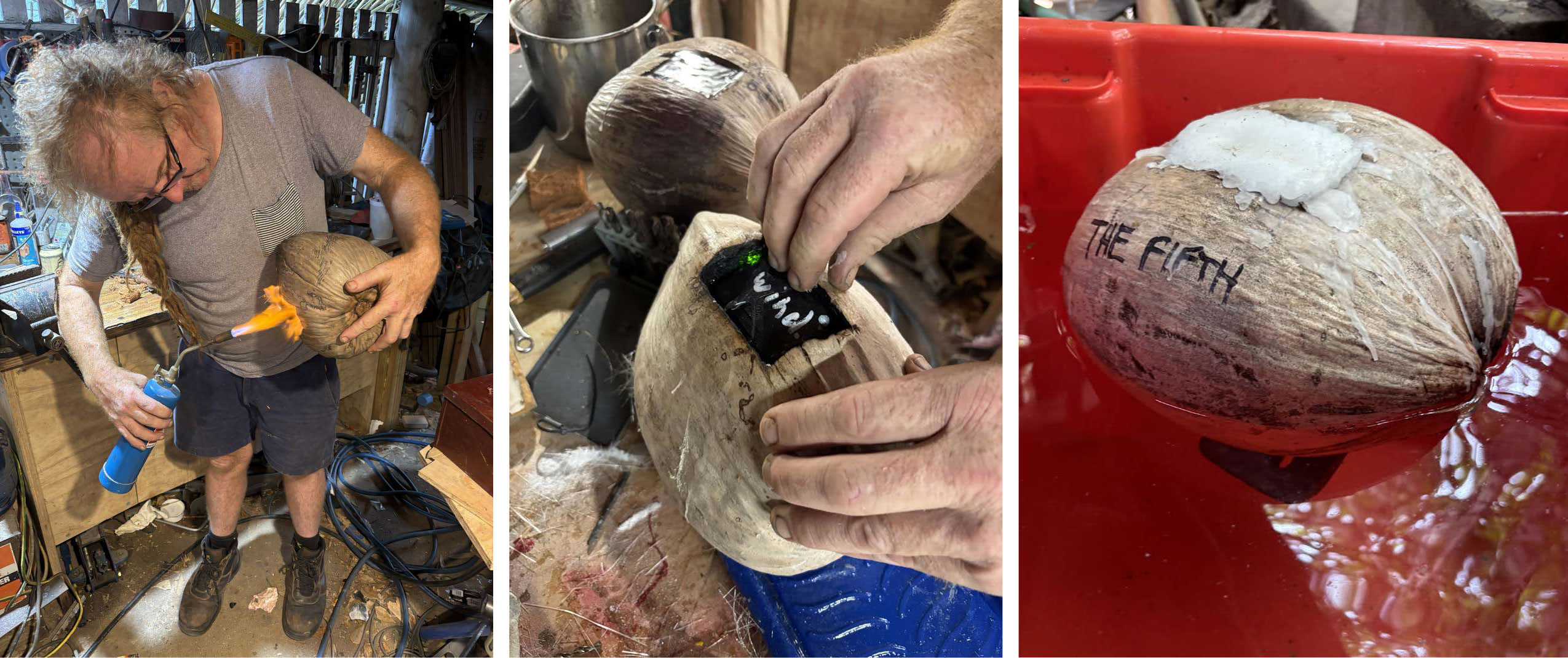
FIGURE 1. Coconut drifter fabrication. After the aperture was heat sealed (left), the tracker was inserted, with the signaling side facing up, into the paraffin wax-coated cavity (middle), and then ballasted using found, recycled, non-plastic materials (right). Image credits: Suzanne Long/RRRC. > High res figure
|
One of the objectives of this experiment was to assess Open-Drift’s capability to resolve the trajectory of the coconuts, working with the results of the Central GBR ROMS model. For surface drifting objects, Open-Drift requires a parameter that describes how much the object is influenced by surface winds. To ensure we could see the effect of surface winds on the coconut drifters, we left approximately 30% of their available buoyancy as reserve by leaving them protruding ~40 mm from the water’s surface.
We sourced a number of 1-, 2-, and 2.5-lb cast iron barbell weights from the Buyback Shop at Cairns Regional Council’s waste transfer station. Dive weights could also have been used. A coach screw secured the weights to the underside of the coconut, situating them so that it would float tracker-up. The screw hole was predrilled and coated with polyurethane wood glue to seal the porous husk and improve the holding ability of the coach screw. Care needed to be taken not to damage the central nut by penetrating too deep into the husk. The entire drifter was then coated in an overall layer of paraffin wax to improve waterproofing and hopefully longevity at sea.
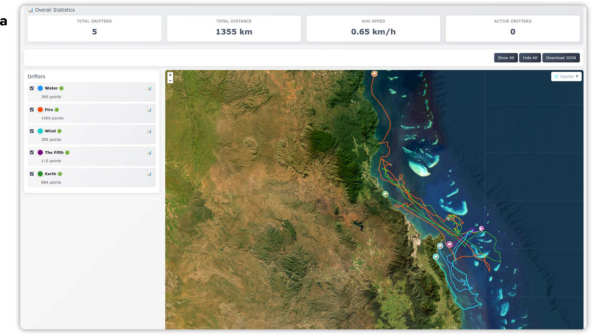
Although the SPOT subscription enables visualization of the tracker’s movements via an in-house website, a custom Drifter Path Tracker website was built by research partner GFD Ltd to enable a better user interface and visualization of multiple tracks simultaneously across different reefs. The Drifter Path Tracker obtained data from SPOT’s website using the vendor-supplied application program interface (API). Latest data were pulled from the SPOT website every 10 minutes using API calls that created and updated a formatted JSON file and updated to the webpage. All partners and stakeholders including Gunggandji Aboriginal Corporation, the Traditional Owners of Moore Reef, were briefed and provided with password-protected access to the Drifter Path Tracker where they could easily view the latest drifter paths.
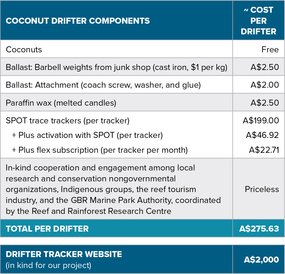
Each drifter cost ~A$276 to make and activate (Table 1), with the vast majority of this expense involving the SPOT trace trackers. The Drifter Path Tracker website delivered in-kind by GFD Ltd for our project is estimated to cost A$2,000.
In US dollars, these amounts are approximately US$196 and US$1,425, respectively. Costs associated with trace trackers may vary depending on jurisdictions.
TABLE 1. Components and costs associated with the coconut drifter project, in Australian dollars (A$). In the event of successful recovery of the drifter after the experiment, the SPOT trace trackers can be extracted and reused to substantially reduce costs for subsequent deployments. The drifter tracker website can accommodate a large number of drifters simultaneously. > High res table
|
Field Application
Five drifters were delivered to our tourism industry research partner GBR Biology and deployed from the Reef Magic pontoon at Moore Reef at hourly intervals during the coral spawning event on the night of the December 10, 2025. Gunggandji Land and Sea Rangers were in attendance as deployment commenced at 21:35 hrs. All five drifters immediately began signaling their positions and continued to do so regularly throughout the experiment, providing stakeholders with a live feed view of their journeys across this region of the GBR.
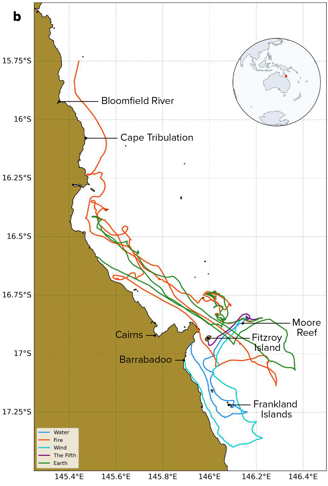
The results were, to be frank, nuts (Figure 2a–c). Between them, the five drifters traveled 1,355 km over the next 27 days, reporting 2,823 good GPS locations. (While we did not test for error in SPOT Trace tracker positioning, others who have, for example, van der Mheen et al., 2020, and Morey et al., 2018, reported a standard error under calm sea conditions of ~4 m, which is negligible.) Interestingly, the first two drifters to be deployed generally followed similar paths over the entire experiment, including substantial movements to the north and back around the deployment reef and finally beaching back in the north. The next two went south as far as the Frankland Islands before returning north to beach themselves on Gunggandji country. The final drifter deployed appeared to be following a similar path before being the first to come ashore on Fitzroy Island, after a journey of just 2.5 days. Inclusion of wind data from the nearby Agincourt No.3 weather station (Australian Institute of Marine Science) in an animation of the drifter tracks showed that changes in wind were one of many factors affecting drifter trajectory (Figure 2c). Other forces related to complex ocean dynamics specific for the region (i.e., baroclinic density currents, tidal currents) were likely also important contributors, creating a complex behavior that warrants further investigation.
 |
 |
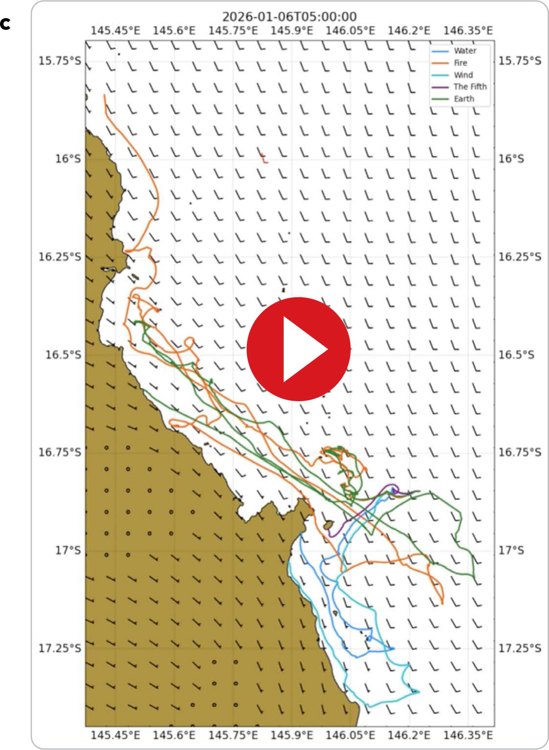 |
FIGURE 2. (a) Snapshot of the custom Drifter Path Tracker website showing the tracks of the five coconut drifters following deployment at Moore Reef, GBR, during coral spawning on the night of December 10, 2025. (b) A map of final coconut drifter tracks (named Water, Fire, Wind, The Fifth, and Earth) showing their journeys off the coast of Cairns, Queensland, Australia, December 2025 through January 2026. The map area is approximately 220 km × 130 km. (c) Animation showing drifter tracks with wind barbs through the central GBR, December 2025 through January 2026, off the coast of Cairns.
|
Four drifters were successfully recovered by stakeholders from where they had beached on coastlines, sometimes requiring significant cooperation among partners (e.g., the Gunggandji Land and Sea Rangers and RRRC making a special joint field trip to a rarely visited location south of Barrabadoo on January 8, 2026; Figure 3). The remaining and longest lasting drifter became entangled in a dense mangrove forest near the mouth of the Bloomfield River after a cumulative journey of 592.24 km and 27 days, where it was judged too risky to attempt recovery (crocodiles, remoteness). This means that four of the five SPOT trackers—by far the most expensive component of the drifter—were recovered, extracted, and can be reused for other projects.
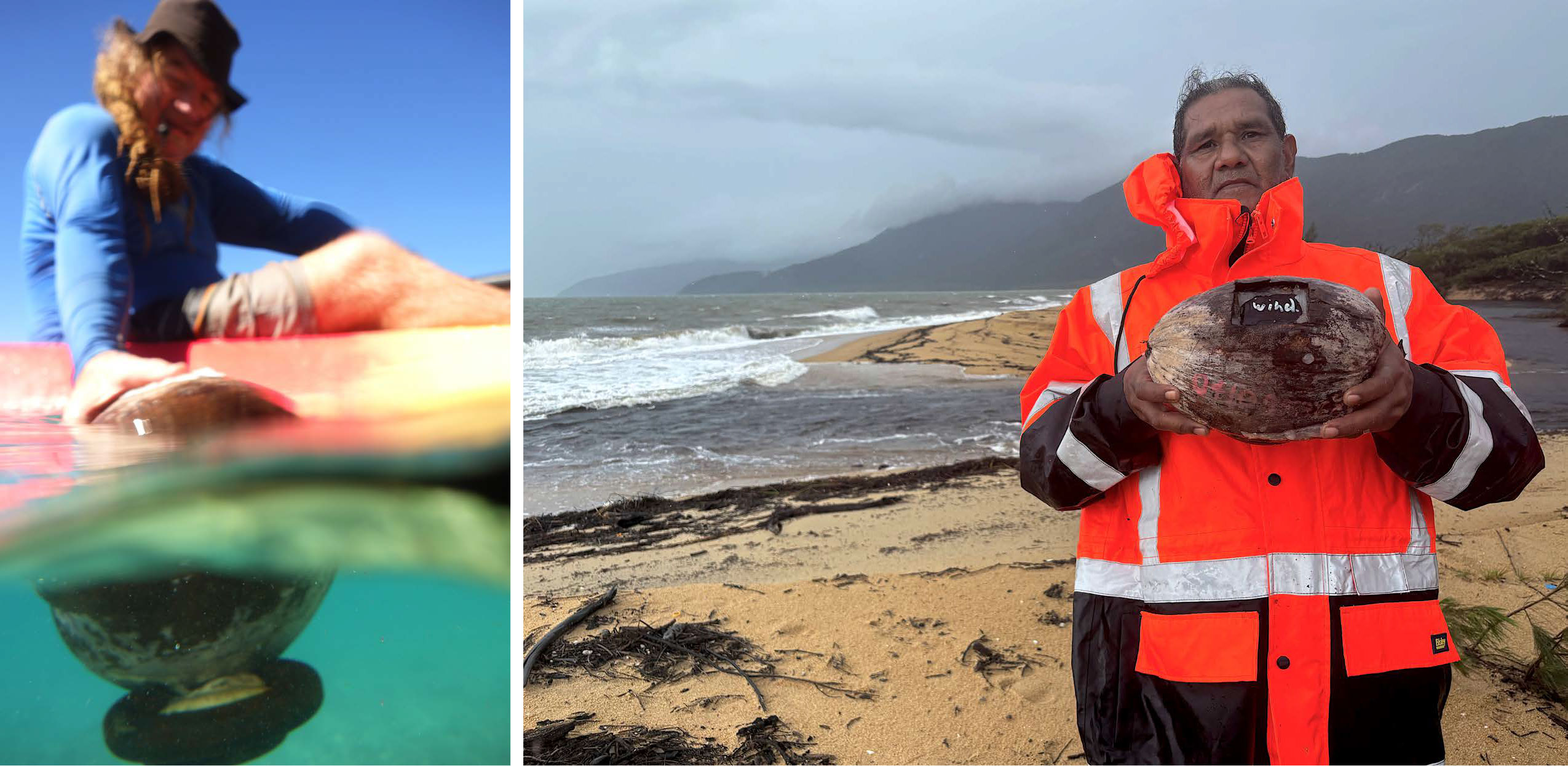
FIGURE 3. Retrieving the coconut drifters. (left) Kayaks loaned by the Resilient Reefs Foundation were used by Dennis Stanley (pictured) and Suzanne Long of the Reef and Rainforest Research Centre to access the southern coastline of Fitzroy Island. (right) Gunggandji Aboriginal Corporation Traditional Use of Marine Resources Agreement Officer Ashleigh Richards holds a coconut drifter retrieved from a remote beach south of Barrabadoo during wet season conditions on January 8, 2026. Note that this drifter had been on the beach at the high tide mark for more than two weeks in summer. Although its protective paraffin wax coating had melted, the tracker was fully functional on recovery. Image credits: Suzanne Long/RRRC. > High res figure
|
Education and Outreach
Gunggandji Elder Shatner Patterson and the Land and Sea Rangers, the Traditional Owners of Moore Reef, were intrigued by the results of this pilot experiment. Culturally, Moore Reef plays an important role in creation stories involving the yam (Kunyaranma) and is commonly considered the “mother reef” of reefs in the region. They have many more questions and applications they would like to pursue using these drifters.
This QA/QC’d dataset can be accessed in JASON format by contacting the authors and will be made freely available via the RRRC website. It is already being used in association with the GBR ROMS model in the 2026 curriculum for postgraduate ocean modeling courses at the University of Western Australia.
Our deliberately low-cost, low-tech approach and the highly engaging custom drifter tracker website, which can be followed by anyone with an interest in the project, put coconut drifters within the reach of schools, community groups, and Traditional Owners all along the GBR coastline. For example, there is already interest from Reef Guardian schools and Junior Indigenous Ranger groups in potentially using coconut drifters to run their own citizen-science projects investigating water movement around their local reefs. Customized drifter tracker websites could feasibly be further customized for specific projects and delivered through local university or high school coding projects.
Future Development
Drifters are used to track the passage of upper ocean currents by passively floating within water as it moves; however, the action of the wind has a large impact on the transport of buoyant objects (van der Mheen et al., 2020), and this was certainly the case for our coconuts (Figure 2c). Undrogued drifters measure near-surface transport, which is strongly influenced by wind forcing, wave-induced Stokes drift, and other ageostrophic processes, making them useful for tracking buoyant materials (Lee and Maximenko, 2025) such as coral spawn. In our case, attachment of a drogue would have risked drifters becoming fouled on shallow reefs in our complex area of operations. However, attachment of various kinds of drogues and other changes to construction and ballasting could adapt them to other applications. Given their simplicity, cost-effectiveness, and engagement power, coconut drifters could become an additional option for programs using a variety of drogued, sailed, and other ocean drifters (e.g., Student Drifters; Xia et al., 2025) as teaching and community-engagement resources.
While SPOT Trace trackers worked well in this application, rapid technological advances in satellite tracking devices mean that smaller and cheaper options may be available. The very occasional incorrect positions reported by the trackers could easily be identified and manually removed from our small dataset.
We found the coconut drifters to be a low-cost, low-tech, robust, accessible, and highly engaging way to collect real-world data to validate the new Central GBR ROMS model. However, drifters characterize only the very surface ocean layer (~20 cm from the surface), while the ocean model top grid cell depends on location and time (the model is a sigma coordinate model with variable depth sigma layers). Another point is that our drifters captured dynamics at local horizontal scales of ~meters while our spatial model grid cell is 1 × 1 km, and it is unrealistic to expect that the model reproduces exact paths. Fair validation would ask for binning all locations within a 1 × 1 km box and computing mean ocean currents for that box—equivalent to a model grid cell. In other words, during the validation process, we must bring both model and Lagrangian paths (drifter trajectories) to the same comparable scalars.
Next steps for our research collaboration will be to use the verified GBR ROMS with Open-Drift modules to increase understanding of the potential dispersal patterns of propagules and larvae of species of interest on the GBR—such as corals, crown-of-thorns starfish, and fishes of commercial and management interest.
Acknowledgments
This project was made possible by funding and in-kind support by RRRC and staff, in-kind trackers and staff from RRF, in-kind support and Rangers from the Gunggandji Aboriginal Corporation, in-kind support and staff time from GFD Ltd, and in-kind staff time from GBR Biology. We specifically thank Lynese Hari, Ashleigh Richards, and Elder Shattner Patterson of Gunggandji Aboriginal Corporation for their enthusiastic participation and willingness to share stories. Robert Wocheslaender (University of Western Australia) assisted in the coconut saturation experiment. This project was conducted under a GBRMPA Part 5.4 Authority held by RRRC to investigate water movements in the vicinity of Moore Reef, GBR. We thank two anonymous reviewers for their comments, which helped improve this manuscript.


 PDF
PDF