Introduction
Environmental changes have been negatively impacting communities in the Arctic for decades. Major shifts in weather patterns and seasonal conditions have been widely recognized and made known by Arctic locals and researchers. Some of the more generalizable changes that affect communities across the Arctic include thawing permafrost, more frequent storm activity, increasingly warm and wet winters, and loss of sea ice. On the local level, each individual community in the Arctic is unique: the geographical characteristics of these communities vary from sandy coastal bluffs to solid bedrock, culture and history are specific to the local areas, every Arctic community faces its own unique sets of challenges and crises, and each community deals with the challenges it faces in its own way.
This article focuses on one Bering Sea community, Unalakleet, at the mouth of the Unalakleet River on the eastern Norton Sound coast (Figure 1). People in Unalakleet have recognized major changes in environmental conditions that have grown increasingly worse over the past 30 years (F. Doty, 2022; G. Doty, 2022; Ivanoff, 2022; Katchatag, 2022; Katongan, 2022; Mustonen and Van Dam, 2021; Paniptchuk, 2022; Slats et al., 2019; Towarak, 2022). One of the major changes people are facing in Unalakleet is the loss of cold and continuously frozen winter seasons. This is related to the loss of sea ice, which leaves a majority of the Bering Sea ice-free during winter months, including the waters adjacent to the Unalakleet area. The open water causes warmer and wetter (e.g., rain on snow events) episodes in winter. The central question we seek to answer here is: how has the loss of seasonal sea ice, and thus open water in winter, impacted traditional subsistence life in Unalakleet, Alaska? This article relies on the observations, experiences, and intuition of people who live in Unalakleet. A variety of resources are utilized, including publications by Unalakleet people, materials directly based on their perspectives, the life experiences of the authors, and unpublished interviews between the authors and Elders (and providers) of Unalakleet. Additional scientific publications and data are referenced to provide context and to further reinforce local observations. Many of the quotations cited in this article are derived from a series of interviews that took place in 2022 in Unalakleet for a project focused on ecological change and Indigenous observing, planned in association with the Native Village of Unalakleet (NVU) and supported by the European Union-funded Pan-Arctic observing System of Systems: Implementing Observations for societal-Needs (Arctic PASSION).
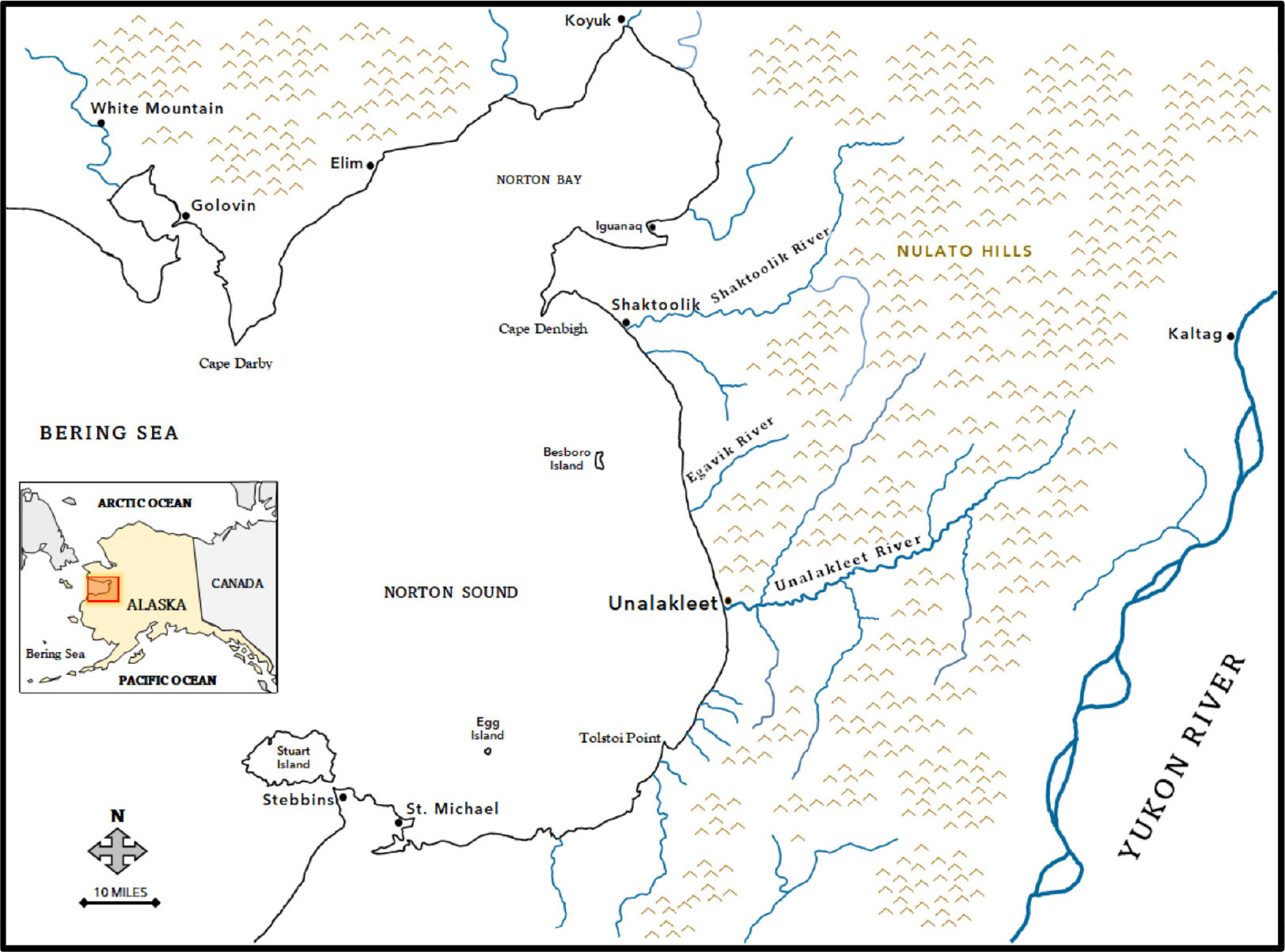
FIGURE 1. Map of the Norton Sound area in western Alaska. Illustration by Ikaaġun Engagement. > High res figure
|
Indigenous Perspectives
This paper may be considered as presenting an Indigenous perspective, as the first author identifies as an Alaskan Indigenous person (Inupiaq and Scandinavian descent). He was raised in Unalakleet and the surrounding area as a hunter and fisherman—and still frequently travels in and around the greater Norton Sound area for subsistence activities and for long distance wintertime snowmachine (snowmobile) trips. The article can also be considered as being based on Indigenous perspectives because it relies on and directly quotes many Unalakleet Indigenous people.
Human perspectives vary drastically among individuals and within ethnicities, cultures, and families. Other than the direct quotes and other references cited in this article, all other text represents the authors’ viewpoints and perspectives. The authors hope this text uplifts the Indigenous voices of Unalakleet. It is also meant to provide readers one example of how, when considered at a local level, people in the Arctic are navigating extremely daunting issues, such as the uprooting of traditional subsistence rounds (the succession of food resources through the seasons), and attempting to overcome these challenges in order to ensure healthy futures.
Context/Setting: Unalakleet
The community of Unalakleet is located on the eastern Norton Sound coast of the Bering Sea at the mouth of the Unalakleet River (Figure 1). The village is the only community in the Unalakleet River basin, which includes 3,246 miles (5,334 km) of river and streams spread over 2,082 square miles (5,392 square kilometers) (BLM, 2000). Headwaters of the main river originate in the Nulato Hills, which average between 1,000 and 2,000 feet (0.3 and 0.6 km) altitude and extend on both the northern and southern sides of the river valley. The foothills nearest to Unalakleet are composed of long ridges and slopes that run from southwest to northeast and meet the coast just north of the village (see coastal cliffs in Figure 3).
Unalakleet is not accessible by road—only by air or seasonal barge. Subsistence resources, most notably salmon, marine mammals, moose, caribou, waterfowl, and berries, make up a majority of most locals’ diets. As in all rural areas of the Arctic, fuel and groceries are very expensive in Unalakleet due to the limited access. In addition to the natural resources available to them, people in Unalakleet access “store-bought” resources purchased from the local grocery stores or flown in from hub locations in Anchorage, Fairbanks, or Nome, and regular postal service, also relatively expensive, allows them to order items from online retailers.
Unalakleet has a deep and rich cultural history. The optimal location of the village provides fresh and clean water sources, good gravel sites for building, and access to a plethora of land and sea resources, such as fish, birds, land animals, berries, plants, and increasingly variable populations of salmon and marine mammals. Historically, Unalakleet has been known as a strategic location for trade among several cultural groups because of its proximity to both the Bering Strait area and the interior Yukon, with trail access through the Unalakleet-Kaltag portage. The portage is a historic trading route now included as part of the famous Iditarod Trail. People from Unalakleet traditionally harvested extra marine resources, including sea mammal products such as seal oil and oogruk (bearded seal) skins to trade with interior communities for furs, wooden spoons, and other products (Koutsky, 1982).
Archaeological evidence suggests the eastern Norton Sound has been occupied continuously for at least 3,000 years (Giddings, 1960; Dumond, 1978), with the specific location of Unalakleet being occupied for at least 2,000 years (Lutz, 1973). Ticasuk, a respected educator, historian, and author from Unalakleet remembered her Elders repeatedly telling her stories about generations of ancestors of the local people in Unalakleet. The ancestors lived at Ayaatayat, “the original village at Cape Denbigh,” which Ticasuk said “is the grandfather of all Eskimo villages in the area,” organized roughly 10,000 years ago (E. Ivanoff Brown, 1987).
In the following sections, we present oral histories and Indigenous knowledge of the weather and subsistence rounds from Unalakleet. We wish to integrate these materials with the knowledge gained by the scientific community.
It is well established in the scientific literature that greenhouse gas emissions from the industrialized world and land use changes are causing far-reaching and accelerating change to the climate and ecosystems of the circumpolar North. Temperature increases across Alaska vary greatly by season and location, with larges increases occurring in fall and winter in the western and northern regions of the state.
Figure 2 plots the trend in annual average surface air temperature at Unalakleet for the available record (1950 to 2020), showing an approximately 5°F (2.8°C) increase in the annual average surface air temperature since 1950.
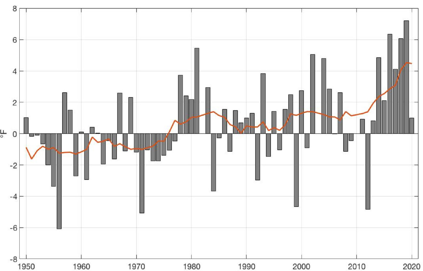
FIGURE 2. Annual average surface air temperature trends (gray bars, overall average traced in red) at Unalakleet, Alaska, 1950–2020, calculated relative to a base period of 1961–1990. There has been an approximately 5°F (2.8°C) change in the annual average surface air temperature since 1950, based on a least-squares linear fit. Data from the NOAA National Centers for Environmental Information (NCEI) Integrated Surface Database (ISD) data set. Graph created by Snowchange Cooperative, 2022. > High res figure
|
Historical Weather Patterns in Unalakleet
Before climate-driven impacts began making large changes to local subsistence cycles (roughly over the past 30 years), the annual weather cycle in the Unalakleet area would shift between two major seasons: cold and dry winters followed by cool and wet summers. Fall, or the transition between summer and winter, was characterized by short stormy periods that ended when Norton Sound and the northern Bering Sea froze solid. Springtime, or the shift between winter and summer, was characterized by relatively calm periods of weather during the “breakup” or thawing of ice and snow. In 1985, the City of Unalakleet produced a village planning document that described the climate and weather the citizens knew to expect every year:
Although Unalakleet’s climate is classified as transitional, two distinct seasons can be distinguished: a dry, cold winter typical of inland continental regimes; and a cool, wet summer, typical of maritime climates. Seasonal change correlates closely with changes in sea ice conditions. Norton Sound is ice-covered in winter, and ice-free in the summer. (City of Unalakleet, 1985)
As noted by the City of Unalakleet, the two major seasons—the cold, dry winters, and the cool, wet summers—correlated directly with the presence or lack of sea ice. The entire Norton Sound would typically freeze over for the winter months, as Elder Millie Katongan remembered: “When I was growing up, the ocean used to have ice as far as you can see. Take long time, even after Memorial Day [May 29], there would still be ice floating around” (Katongan, 2022). Another Unalakleet Elder, Sheldon Katchatag Jr., remembered a roadhouse located on Besboro Island (Kikiktaq) used as a resting place by dog-sled mail carriers as they traveled the over-ice trails that cut straight across the frozen Norton Sound during the winter months:
An example is the roadhouse at Kikiktaq, Besboro Island. They needed that lodge there for their dog mushers that were carrying the mail. And they used to run almost straight from here [Unalakleet] to Cape Denbigh, to Elim, they could go straight [across the ice] because the water froze that much. (Katchatag, 2022)
Traditional Springtime Hunting
One of the most important times of the year, traditionally, was oogruk and seal hunting. Local people in Unalakleet distinguish the much larger “oogruk” separately from all other seal species, which are referred to as “seals.” Oogruk and seal hunting was in the springtime, “when the ocean ice is floating around in chunks. During this time of year, the seals rest on the ice after migrating from the south” (Creative Writing Class of CHS, 1978). As Jorgensen (1984) stated, “the activities of the late spring season consumed the attention and energies of the village. Every chance they got people went out looking for oogruk.” Hunting for marine mammals was one of the most important activities for Unalakleet people, as local Inupiaq educator Martina Bailey (Partnow, 1986) shared in 1986:
But of all the animals we hunted, the seal was the most important. The best times to hunt seals are spring and fall. The seals are migrating at those times, and many are in Norton Sound, the part of the sea that is next to Unalakleet. Seals will bask on ice floes.
The late Unalakleet Elder, John Auliye, explained in 1978, “Long ago old hunters used to pull their kayaks way out to an open lead on the ice and hunt seals. Nowadays they use snowmachine” (Creative Writing Class of CHS, 1978). The edge of the ice would typically be so far offshore that hunters traditionally used Egg Island (34 miles [55 km] from Unalakleet) for a basecamp from which to pull their kayaks with a sled over the “old ice” (thick, shore fast ice) to the ice leads further from Egg Island (E.T. Ivanoff Brown, 1974).
The traditional seasonal subsistence rounds in Unalakleet correlated directly with ocean conditions, particularly during spring. A federal report on subsistence activities from the early 1980s by Jorgensen (1984) found that in Unalakleet, “Ice conditions and water temperatures affect the time and arrival of the spring birds, fish, and sea mammals, whether they come within hunting range, and their numbers.” Emily Ticasuk Brown (Ivanoff) described the change of weather in the spring, “During the latter part of May on the coast of the Norton Sound, the Eskimos are usually set free from the firm grip of the wintry blast” (E.T. Ivanoff Brown, 1974). Springtime has always been an extra special time for communities in the Arctic with the return and reciprocity of animals and plants. Unalakleet Elder Lorena Paniptchuk fondly remembers the excitement for fresh foods from spring hunts:
Men go with dog team, when they go hunt caribou, we’re real happy. If they get, they’ll share, each home, enough to cook even. When they go seal hunting, when they come home, they bring and cut enough for a pot for each home. Boy, we used to be real happy, I can’t wait for them, like April, that’s the time they get crab and those rockfish when the ice first go. That’s why I still like to go rock fishing, I just got to have them springtime. (Paniptchuk, 2022)
Predictable Seasonal Subsistence Rounds
To survive in the Arctic, people must constantly overcome challenges, obstacles, and crises. Over a very long time, Indigenous peoples in the Arctic have built a body of knowledge and technology to efficiently utilize environmental and subsistence resources that follow seasonal shifts in climate and weather conditions. Predictable seasonal rounds were a common characteristic across all communities in the Bering Sea region. In 1982, while describing more general characteristics that all Bering Sea communities share, Fitzhugh and Kaplan (1982) spoke of the distinct and predictable seasonal rounds that allowed local residents to “make efficient use of game available at different places and times of the year. For the most part, these changes are broadly predictable from one year to the next” (Fitzhugh and Kaplan, 1982).
Traditionally, Unalakleet people were able to maintain a schedule that followed an annual cycle. During the early 1980s, a group of researchers worked closely with local leaders and stayed in Unalakleet for six months from late winter until the following fall. According to Jorgensen (1984), the researchers took part in subsistence activities to document ethnographic information about “the manner in which they (Unalakleet residents) use their environment, the ways in which they are organized to do so, and the meanings which they attribute to it.” The detailed 400-page report frequently refers to the seasonal subsistence cycles in Unalakleet:
In their mental calendar, people know the order and pace with which resources follow each other, as well as the combination of resources that are available at any given time. People fine-tune their mental calendar each year, figuring for that year as precisely as they can for days or weeks the arrival of the foods, their duration and time of best harvesting, and the speed at which they will follow each other. (Jorgensen, 1984)
People in Unalakleet would be able to go about their seasonal rounds by carefully watching and responding to the environment:
People draw on their own knowledge of the cycle and habits of the animals and plants, of the influence of the weather and ice conditions on the availability of these resources, and the signs they observe in nature which tell them more exactly what the year’s calendar will be. (Jorgensen, 1984)
Of course, people in Unalakleet still live, day-to-day, directly in response to weather, climate, and the availability of resources. Unalakleet Elders reminisce about the traditional or normal, seasonal schedule they remember as children and young adults:
So, when I talk about the old subsistence lifestyle (in Unalakleet), everything was on schedule, you know, because life was pretty much normal, the way they knew it. (Towarak, 2022)
Consequences of Sea Ice Loss Today
Disruptions to Traditional Subsistence Cycles
Climate-driven impacts are some of the biggest threats to traditional subsistence cycles in Unalakleet. As quoted in the NOAA Arctic Report Card 2019, Unalakleet Elder Jerry Ivanoff acknowledged that, “There’s less and less snow, and there’s less and less ice, and that means trouble, not only (for) us hunting and fishing, but the animals that we depend on” (Slats et al., 2019). Today, people in Unalakleet are faced with completely unpredictable seasonal rounds. Unalakleet Elder, Clarence Towarak Jr., or “Junie,” shared that people need to continually adjust to unpredictable conditions:
It’s puzzling for us, anyway, because we’re all used to a certain day, the salmon are supposed to be here, certain season they’re supposed to be running good. Certain season they’re all done. But it’s changing so much, you have to figure out what’s happening, and do things accordingly. (Towarak, 2022)
Marine Mammals Hunts
As noted, traditionally, the marine mammal hunt in the spring season was very important, and it is still extremely important to people in Unalakleet. However, after decades of increasingly variable conditions, hunters in Unalakleet struggle to provide their families and fellow community members with oogruk and other marine mammals. One of the primary issues is that oogruk need flat ice to rest and live on, and for most of the year, the ice simply does not exist in the Bering Sea (Figure 3). One hunter in Unalakleet shared that:
Now days you can go boating in December, January. Back then, you weren’t able to go boating, it was all pure ice. You were able to go 15–20 miles out [on the ice]. Nowadays we don’t have sea ice anymore. (G. Doty, 2022)
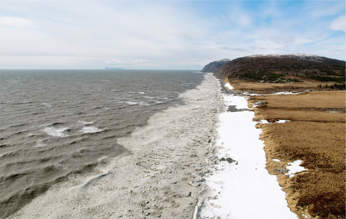
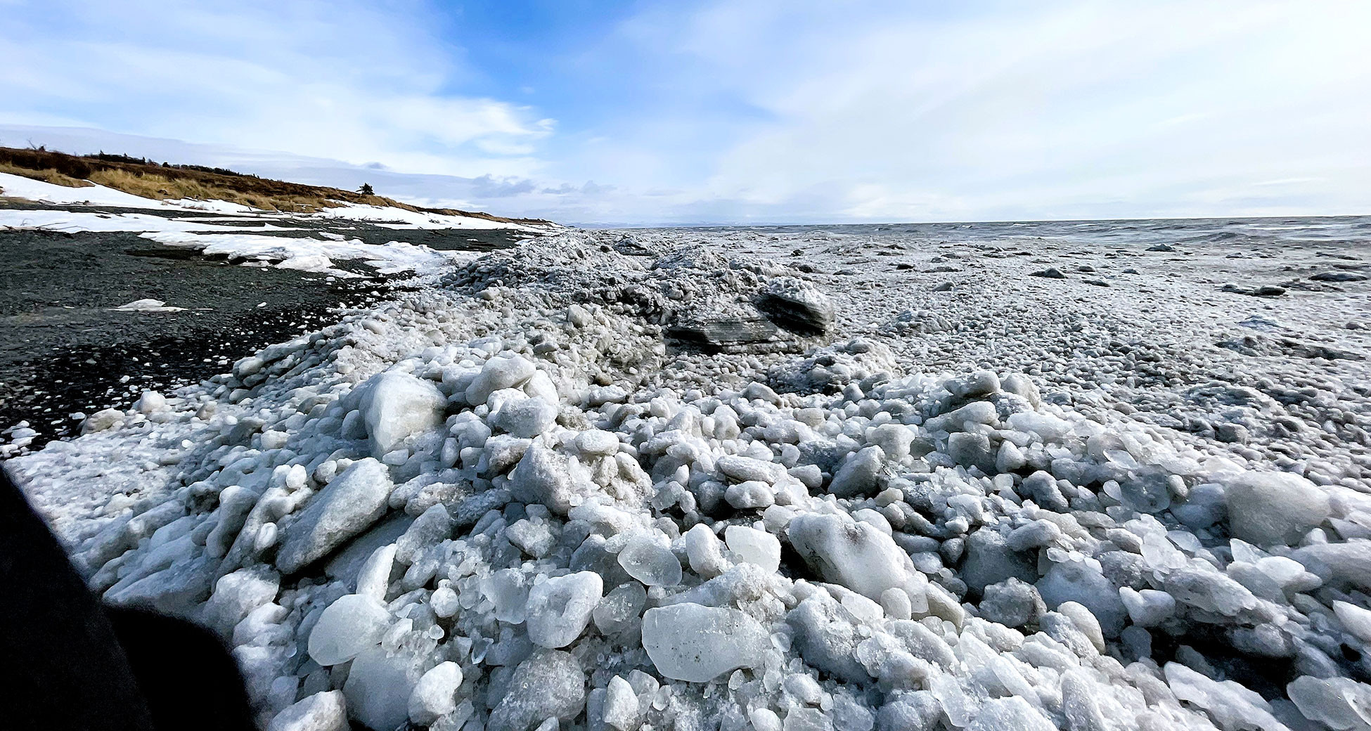
FIGURE 3. Norton Sound coast three miles north of Unalakleet showing open water and slush ice during spring 2022. Traditionally, shore fast ice would extend from the coast during this season Photo credit: Ikaaġun Engagement. > High res figure
|
Even if you travel far out in the open water with a small boat and come across an oogruk in the water, if you are successful, it can be very dangerous to attempt to butcher the animal without a solid ice platform to work from, especially because many oogruk are too big to pull into smaller watercraft.
Without that sea ice, you have to travel 15–20 miles [over open water] to just to get out where the oogruk are. And when you do catch it, usually you butcher it on a piece of sea ice, but without no sea ice, you would have to haul it 20 miles back to land or to a piece of sea ice to butcher it. (G. Doty, 2022)
Unalakleet Elder Jerry Ivanoff describes a hunting trip for oogruk in the spring of 2020 that forced him and his crew to travel over 200 miles (322 km) in open water to finally locate and catch one oogruk:
I normally go oogruk hunting right out here, right off our shore, I get them five miles out. Two years ago, I went oogruk hunting with my partners, Ronnie, Wayne, and Don. We went oogruk hunting, we went to Besboro Island, we went to Cape Denbigh, we went halfway to Koyuk, and we ended up at Iguanaq, you know on the ice out there. There’s no oogruk, but there’s seals all over [the shore-fast ice]. I’m looking for oogruk, you know, this is what I want to put on the table, something I’ve done my whole life. So, we come back down, go to Cape Denbigh, and we go out 20 miles, thinking we’d find ice. But there was no ice, so we V-lined it home. We filled up with gas, the next day we took off and ended up at Egg Island. There’s no ice, just shore-fast ice with seals on it, and we can’t get on it, because the weather is north wind. So we ended up spending the night at Egg Island, pretty cold. And then we took off in the morning, as soon as it got bright, we go to Stuart Island. And then from Stuart Island, the floating ice was 10–15 miles to the southwest, and we got an oogruk then. (Ivanoff, 2022)
Another Elder in Unalakleet reemphasized the struggles the oogruk hunters of Unalakleet face with the changes:
Things are changing so fast with this climate change, even the hunting is really hard, you can tell just by watching how these guys are struggling to get some oogruk. There aren’t that many people that got oogruk this year [2022]. And the weather has been so bad, and it’s all because of climate change. We’re getting more and more storms that are not natural, at certain times of the year. (Towarak, 2022)
It is important to recognize that there are times every year that sea ice begins to form in the waters of Norton Sound surrounding Unalakleet. However, frequent storms and high wintertime winds tend to break up the ice and blow it away. Unalakleet Elder Sheldon Katchatag Jr., also known as “Shacky,” explained the situation:
One of the things that concerns me the most is the loss of our winter ice. I was amazed that even though we had the sixth coldest winter on record this last 2021/2022, I assumed that we would have ice until May or June. Because we were having approximately 30 below weather in Nome just about every day. And I knew that ice was getting thick out there, and it was all covered. And I thought, as thick and as expansive as the ice is, I don’t have to worry about Norton Sound not having ice next spring when I go hunting. And boy was I fooled. We had a December storm, when it finally warmed up, and we had two days of sustained winds in excess of 50 miles per hour, with peak gusts in the 70s, hurricane-force winds. And it blew for three days from the east, calmed down for half a day, and blew 60 miles an hour from the west for three days. And it blew me away. And it also blew the ice away. It never used to happen like that, whenever you had a really cold winter, the ice was there for the winter, and it would stay. (Katchatag, 2022)
Other Subsistence Activities
Although this text has focused largely on the spring marine mammal hunt, the loss of sea ice has negative impacts on several other subsistence activities. When sea ice is present in Norton Sound, it is used as a platform to travel up and down the coast to go caribou hunting, to hunt and trap fur-bearing animals (e.g., wolf, wolverine; Figure 4), and to set crab pots through the ice for wintertime crabbing. Caribou migrations can vary greatly in location from year to year. Over time, migrations can shift into and out of the Unalakleet River basin area. For several years, especially more recently, caribou have stayed far away from Unalakleet, requiring local hunters to travel extraordinarily long distances to catch caribou. One Unalakleet hunter explained the situation:
Our winter, we used to catch caribou right in our back yard, and now with the climate warming, we have to travel at least 200–300 miles [one way] just to catch our caribou during the winter season. Also, during the winters we used to do a lot of crabbing though the ice, and without ice during the winter we can’t actually go and catch our subsistence crab. And it has an impact on us, because that’s our traditional food that we eat during the winter is caribou and crab. And with climate warming, it’s hard to travel without no snow, and there’s tundra. (G. Doty, 2022)
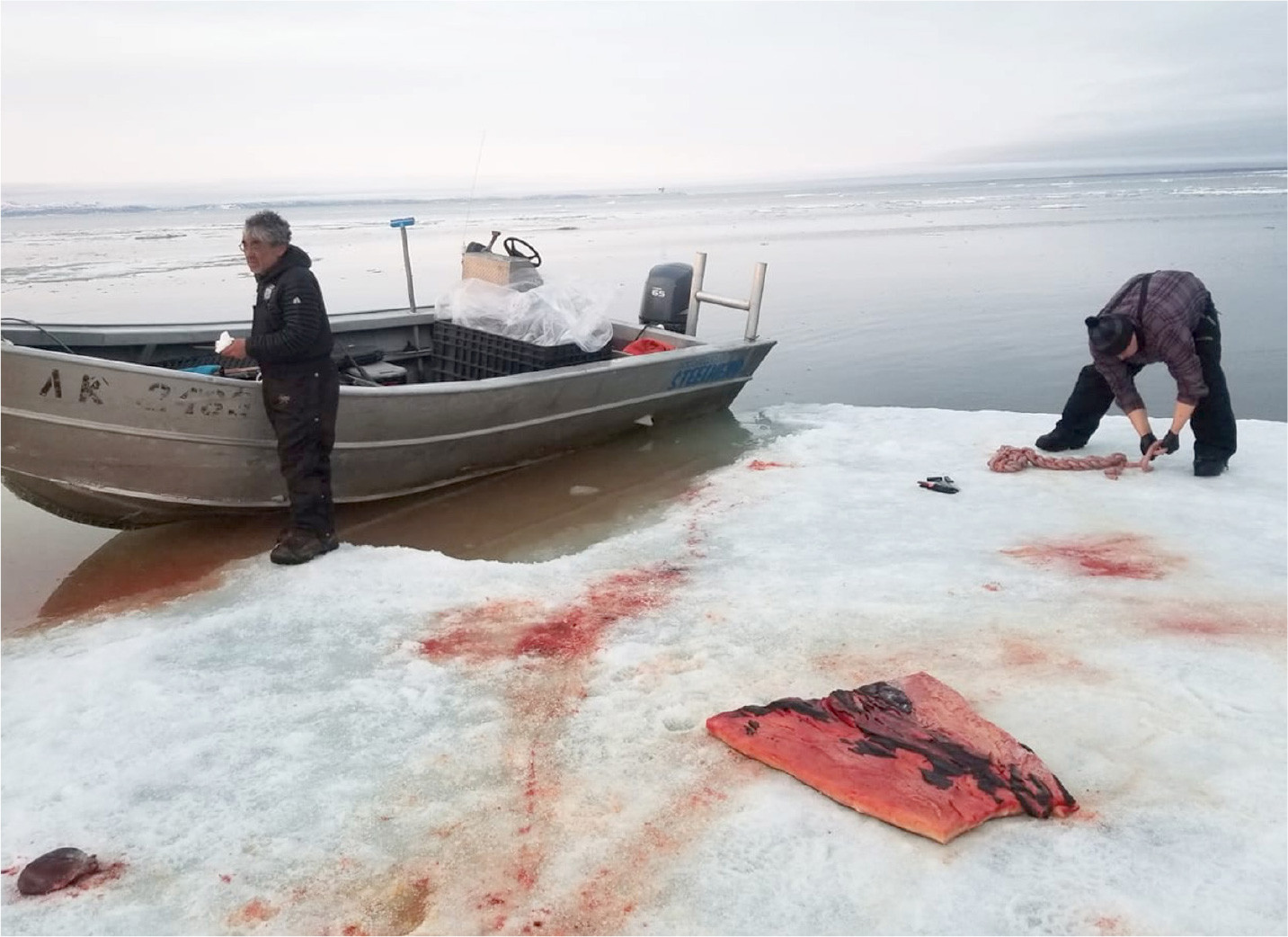
FIGURE 4. A rare piece of ice allowed spring hunting in Norton Sound in 2017. Photo credit: Frank Doty. > High res figure
|
In 2003, Palmer Sagoonik, a respected hunter, fisherman, reindeer herder, and leader in Shaktoolik, the next community 35 miles [56 km] up the coast from Unalakleet, talked about changes he already observed by the early 2000s in relation to the caribou migration, which was shifting more northerly. His perspective is crucial because reindeer herders tend to spend extensive time throughout the entire yearly cycle traveling the land and watching the conditions.
I think the caribou migration changed because of the weather pattern change. It’s warmer up here and they can range further then they did back when it was colder. Weather had a lot to do with it. Freeze-up was later, spring was earlier… The winter seasons are not as cold. Back in the easy days, reindeer herding was easy because we didn’t have as many warm spells, and we had a lot more snowfall. (Sagoonik, 2003)
With increased moisture in the air from the open water, in addition to the warmer weather, the Unalakleet area now has a high number of rain events during wintertime. Rain in the winter can be devastating for the animals. They may have trouble accessing their food because winter rain forms a layer of ice that covers and encases the plants and foods. Reindeer and caribou are especially affected because the mosses they prefer become covered in ice, explains Unalakleet Elder Shacky:
So, because of the freezing rain events, it seals the food away from the caribou, they can’t get at it. So, they didn’t come down this year, and this is the first time I ever heard of people from Koyuk having to go like a hundred miles [north northeast from Koyuk] just to find caribou…and that’s what worries me about winter storms where we get a lot of freezing rain. And this last winter was terrible as far as freezing rain, this place was dangerously slick. (Katchatag, 2022)
Icy conditions on the tundra due to moisture in the environment can also heavily impact the ability of hunters and overland travelers to cross the land during the winter, as explained by a Unalakleet hunter:
The winter is shortening. Back when I was a kid everything froze over in the middle of September when school started. But as you know now, it’s rained every month throughout the winter… Traveling was tough this year [2021–2022], just having all ice [covering the landscape]. Traveling was limited this winter because if there wasn’t any snow to cool off the [snow machine] engines, some people blew up their engines. (F. Doty, 2022)
Increased Coastal Erosion
We have focused here on how sea ice loss impacts traditional subsistence cycles, but it is important to note that the warmer winters and increased storms associated with open water in the Bering Sea during winter also significantly impact the coastal landscape. Although permafrost thaw is affecting both coastal regions and lands in the interior Arctic, lands adjacent to the coast surrounding Unalakleet have begun to thaw at extremely high rates, creating dozens of large sinkholes, some as big as a half-mile (0.8 km) wide, on the coastal banks near Unalakleet (Figure 5).
They [sinkholes] have really expanded in the last four years. I’ve watched the coast between here [Unalakleet] and Tolstoi Point. Just about every year another pocket of permafrost would thaw, and it would melt and dissolve all the mud around it, and it would melt so fast that it would just flow all the way to the beach. And at first there was only like three or four, mostly down on the hills…but they’re on all the banks. (Katchatag, 2022)
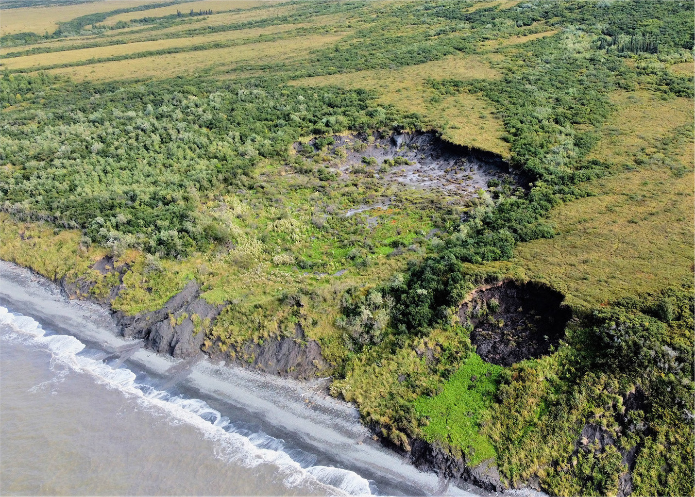
FIGURE 5. Thawing permafrost resulted in a large, older sinkhole (left, with vegetation growth inside) and a new sinkhole (right, with dark soil) on the coast six miles from Unalakleet. Photo credit: Ikaaġun Engagement. > High res figure
|
Conclusions and Moving Forward
Changes in climate and weather are not only severely affecting Indigenous subsistence rounds in Arctic regions, they are profoundly impacting people across the globe, as the Secretary General of the United Nations stated:
Our climate is heating rapidly. Floods, droughts, heatwaves, extreme storms, and wildfires are going from bad to worst with ever-alarming frequency. Heatwaves in Europe, colossal floods in Pakistan, prolonged and severe droughts in China, the Horn of Africa, and the United States. There is nothing natural about the new scale of these disasters. (United Nations Web TV, 2022)
Communities across the Arctic face unique sets of challenges. The impacts of major climate changes, such as thawing permafrost, warmer and wetter winters, and loss of sea ice, are felt by many communities and regions across the Arctic. The impacts of the loss of sea ice in the Bering Sea, and the correlated increased prevalence of open water during winter and spring months, have uprooted traditional subsistence rounds in communities across the Bering Sea coasts. During a presentation in 2019 at the National Academy of Sciences in Washington, DC, Delbert Pungowiyi, a respected leader from the Bering Sea region, described how sea ice loss has impacted his home community of Savoonga:
When there is open water, it is not winter to us. Only when the whole of the Bering Sea is completely locked up, that is winter. The winter we have now is three months, to us that is not winter anymore. (Pungowiyi, 2019)
Over the course of the last 30 years, the increased prevalence of open water during winter months has severely impacted the traditional subsistence rounds in Unalakleet. Historically, the waters near Unalakleet would be frozen solid throughout the winter, which would cause cold and dry winters, similar to interior Alaska winter climate regimes. With the increased prevalence of open water in the Bering Sea, the adjacent coastal areas have warmer and wetter winters, which cause a suite of issues associated with subsistence hunting and gathering. The lack of sea ice does not allow Unalakleet residents to regularly access and harvest marine mammals upon which they have traditionally relied. Good hunting conditions are rare, and the changing marine landscape has forced marine mammals and other species to change migration patterns, further complicating subsistence hunts.
As noted in this paper, the loss of sea ice and associated open water in the Bering Sea is just one of the major issues facing the people of Unalakleet. The most notable “other” issue is the decline in annual salmon returns and the decreasing sizes of salmon. It is important to avoid assuming general climate changes are the only factors responsible for the decline in annual salmon returns and salmon size. Indeed, many people in Unalakleet and across Alaska feel that certain commercial fishing activities are impacting the subsistence salmon harvest and that changes in the environment are being used as an excuse.
It is the nature of Arctic people to overcome extreme challenges and to effectively move on to the next obstacle. Indigenous and local people in the Arctic have continued to adjust their subsistence cycles in response to major changes to weather and seasonal patterns and shifting migration of animals. People in Unalakleet miss the old days, not just for nostalgia, but because the climate was much different, much more predictable, and most important, much more reliable. They miss the cold and dry winters that allowed them relatively easy travel to access resources.
It sure has changed in 20 years, from what we’re used to having, and having that taken away. And having to adjust to it, adjust to the land, because you can’t change it. (G. Doty, 2022)
An important characteristic of many people in Unalakleet—and maybe the central key to survival in the Arctic—is to have a positive outlook in the face of challenges and crises.
Things have changed. I almost feel like I need to move a little farther north, just to be in the Arctic [laughter] just cause it’s so warm. I mean, no winters, and monsoon season all summer long. (F. Doty, 2022)
The people of Unalakleet, like those in every community in the Arctic, will continue to face and overcome challenges as they arise. The question is: are any of these challenges avoidable? Threats to the subsistence lifestyle in rural areas of the Arctic, whether from environmental changes or over-utilization of commercial resources, are extremely daunting to local and Indigenous communities. However, Arctic communities are made up of intelligent, thoughtful, and strong people who have children, futures, and unique traditional lifestyles that will continue. Our people will hold onto memories, prepare for the worst, fight for the best, and continue to live.
Acknowledgments
The article has been supported by “Arctic Passion,” the European Union’s Horizon 2020 research and innovation programme under grant agreement No. 101003472.