Full Text
Healthy beaches are essential for managing the coastal zone, including growing coastal tourism, maintaining seaside property values, developing infrastructure, and sustaining coastal ecosystems and communities. Beaches worldwide face problems such as erosion and shoreline recession caused by both natural factors and anthropogenic pressures. Beach erosion is caused by short-term fluctuations such as storms or by longer-term processes related to sediment budget deficits, rising sea levels, and wave regime changes. Responsible beach management requires precise knowledge of the short-term fluctuations and long-term processes involved in coastal evolution in order to assess the risks to infrastructure and to identify acceptable weaknesses in future development or in coastal management. Knowledge of short- and long-term shoreline changes could also contribute to the design of beach nourishment plans so that human activities can be conducted consistent with natural processes rather than in conflict with them.
This study focuses on the need for an Environmental Alert System for Timely Maintenance of the Coastal Zone (EASTMOC) along Lithuania’s Baltic Sea coast. It is based on coastal research conducted in the Port of Klaipeda. Because this area is affected by constant dredging of the port, intensive shipping, recreational zones, and continuous reconstruction of jetties, it is important to create an environmental alert system for timely port maintenance.
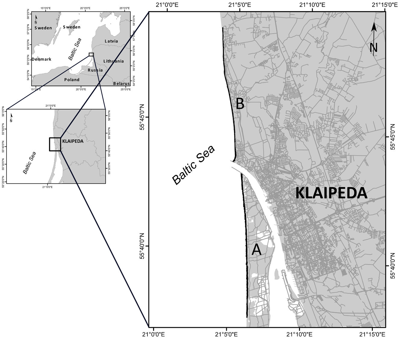
THE KLAIPEDA PORT IMPACT ZONE
The Lithuanian Baltic Sea coast is affected by wind and waves from a wide range of directions. The study site was chosen based on its (1) broad spectrum of recreational uses, (2) high risk of coastal erosion, and (3) possibility of direct and indirect anthropogenic impacts.
The Port of Klaipeda is located at the Klaipeda Strait and divides the Lithuanian coast into two morphologically and geologically diverse parts: the Curonian Spit coast to the south and the mainland coast to the north (Figure 1; Bitinas et al., 2005). The port’s jetties disturb the main sediment transport path (from south to north) along the Lithuanian coast and significantly influence its northern sector.
|
|
Analysis of long-term trends in shoreline change show that shoreline formation processes, which determine and form the balance of shoreline change, have intensified due to port reconstruction. Net shoreline movement analysis for the entire 1993–2022 study period (Figure 2) shows that 39.05% of the shoreline was erosive, 34.04% was accumulative, and 26.53% was stable or within the range of uncertainty (±5.02 m). A comparison of shoreline changes for the periods 1993–2003 and 2003–2022 shows that the area of eroded coast increased 4.4 times, from 2.73 km to 11.90 km. Significant coastal erosion (−51.95 m) extends north from the port jetties of Klaipeda. Shoreline positions were determined from sets of aerial photo charts, orthophotos, and GPS survey data. Measurements of coastline position were collected in the middle of the swash zone using Leica 900 dual-band GPS receivers. Historical coastline positions were measured every 25 m along the coastline. Three coastline positioning and detection errors were calculated (see Crowell et al., 1993), and shoreline position changes were analyzed with the ArcGIS extension DSAS v. 5.0 (Digital Shoreline Analysis System) package developed by the US Geological Survey.
|
|
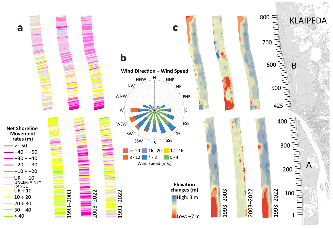
Coastal geomorphology and underwater elevation changes calculated from bathymetry data using Global Mapper software helped to identify that reconstruction and continuous dredging of the Port of Klaipeda influence the sediment budget along the study area. In the period 2003–2022, about 2.5 km north of the port jetties, a bottom sediment deficit was observed, with the coastal elevation reduced by about 5–7 m (Figure 2).
EASTMOC
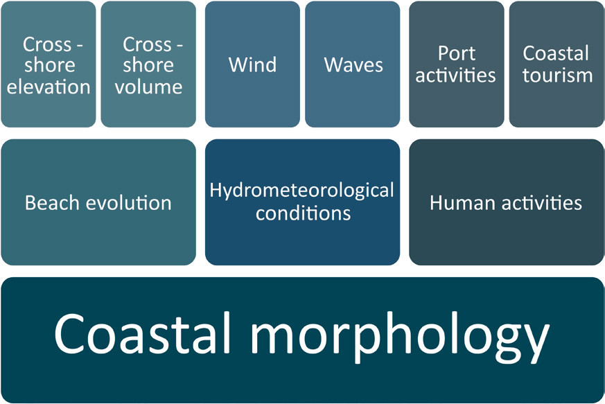
EASTMOC combines research and monitoring of coastal morphological features, hydrometeorological conditions, and human activities, which are critical inputs to an environmental warning system (Figure 3). In order to ensure that EASTMOC addresses stakeholders’ needs, interviews with stakeholders helped to identify the data they use in day-to-day operations (e.g., wind speed and direction, wave direction and height, water and air temperatures, atmospheric pressure), data gaps, and data sharing practices, as well as to determine the relevant thresholds for various industries. Stakeholders are interested in hydrometeorological thresholds because they limit the activities of port authorities, passenger ferries, and commercial fishermen. For example, strong winds (≥15 m s–1) limit local passenger ferry traffic, interrupting transportation links to the Curonian Spit. They also disrupt port activities, sometimes resulting in port closures to ship traffic for several hours or days. In addition, the long-term effects of local hydrometeorological conditions can lead to adjustments in municipal to national-level strategic plans.
|
|
Bayesian networks are well suited for explicitly integrating both prior knowledge and information obtained from daily environmental observations. As determined in previous studies based on Bayesian networks, there is a correlation between socioeconomic and natural factors, such as air and water temperature, the presence of dunes and sandy beaches, and tourists’ recreational needs (Baltranaitė et al., 2021). EASTMOC will include quantitative assessment and prediction modeling based on the Bayesian networks to ensure sustainable planning and operation of all parties active in the study area. The current stage of development of EASTMOC includes creating a network of data sources to ensure data availability and accessibility among stakeholders. These sources are essential to the alert system concept, as the thresholds will be set based on these data.
The database compiled in EASTMOC will be directed to the stakeholders and end users. Stakeholders involved in the development of EASTMOC will receive tailored alerts generated according to the thresholds that are relevant to their specific activities. While some end users require simple wind speed and direction warnings, others need more complex correlation of several data sets. However, EASTMOC may become relevant to the general population and further adapted on a smaller scale. For instance, beachgoers and extreme watersport enthusiasts may benefit from strong wind warnings while planning a day out, as strong winds may not be favorable for sunbathing but beneficial for extreme sports.
EASTMOC has the potential to fill the gap in access to current data, serve as a hub for knowledge sharing, and provide early warning to stakeholders in accordance with the thresholds set up in line with the specifics of their activities. Though our study area is significant on a regional scale, our research methodology can be adapted to assess similar coasts worldwide.