
Full Text
In 1975, an underwater landslide in Kitimat Arm at the northern end of Douglas Channel, British Columbia (Figure 1a), triggered tsunami waves that were observed to reach a height of over 8 m at the head of the inlet, destroying a dock and a newly built barge terminal (Bornhold, 1983). Elsewhere in the Douglas Channel region, seafloor deposits attest to previous submarine landslide events (Conway et al., 2012; Stacey et al., 2019), and subaerial landslides of various sizes regularly occur (Maynard et al., 2017). Landslide-generated tsunamis are increasingly recognized as a substantial hazard worldwide, with the potential for extreme wave runup and localized damage, particularly in narrow, steep-sided bays and inlets. In most cases it is not possible to prevent landslides from occurring; however, mitigation efforts can include early landslide detection and the development of tsunami early warning systems using real-time data.
|
|
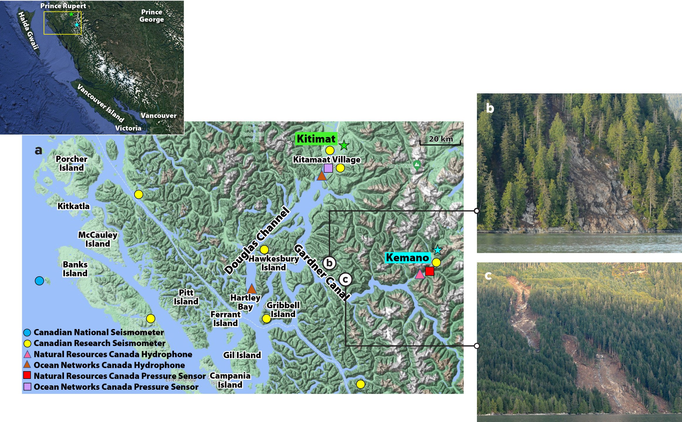
The Douglas Channel region provides an ideal location for developing and testing a landslide and tsunami detection system. Douglas Channel and Gardner Canal, a side inlet, are located in a complex coastal area with a history of landslide-generated tsunamis. The district of Kitimat, the villages of Kitamaat and Hartley Bay, the traditional territories of the Haisla and Gitga’at Nations, and various sites of infrastructure, including ports and the Rio Tinto Generating Station docks near Kemano, are all at risk of damage from landslide-generated tsunamis.
Throughout the steep-sided Douglas Channel and Gardner Canal region there are many potential source locations for both subaerial and underwater failures that may be triggered by heavy rainfall, tidal loading, earthquake shaking, erosion, or changes in groundwater pressure (Lintern et al., 2019; Stacey et al., 2019). The 8 m 1975 tsunami was caused by a submarine failure of delta sediments (e.g., Skvortsov and Bornhold, 2007), and there is ongoing potential for large rigid subaerial landslides. Figure 1b,c shows two examples of landslides that occurred in Gardner Canal in 2017, triggered by heavy rain.
A System for Early Detection of Landslides and Tsunamis
The Douglas Channel and Gardner Canal landslide and tsunami detection system is based on a network of land-based seismometers, underwater hydrophones, and bottom pressure sensors (Figure 1a). The seismometers and hydrophones will be used to detect and locate landslides, with water level observations provided by the bottom pressure sensors.
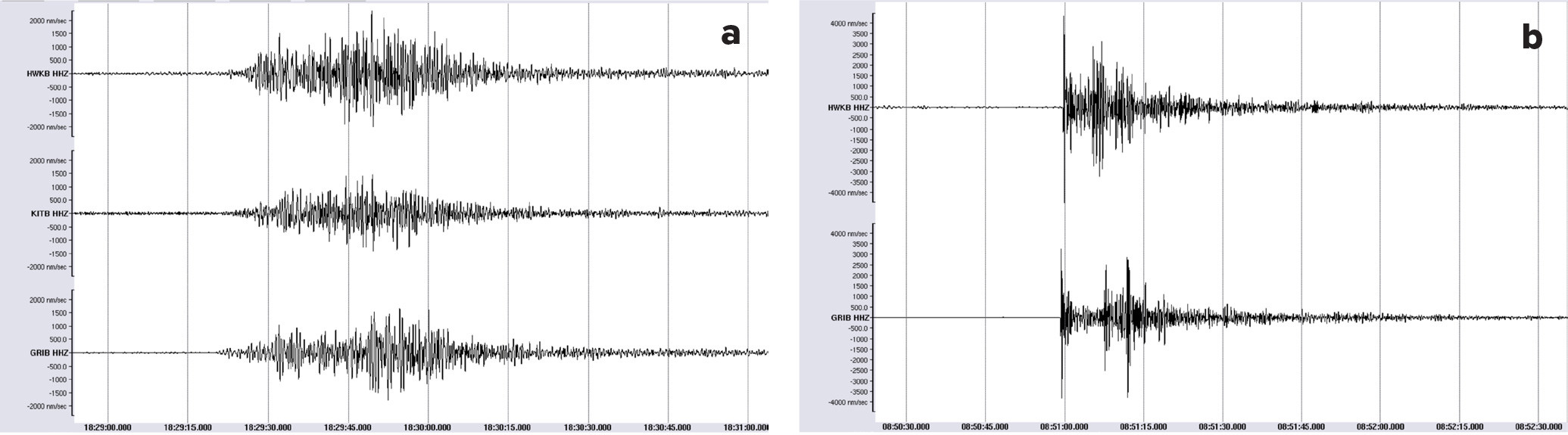
Seismometers are the principal tool for measuring earthquake energy; three-component instruments record a time series of ground motion in three orthogonal spatial orientations. Landslides produce high-energy, low-frequency signals that can also be captured by broadband seismometers located at large distances from the source region (dependent on landslide volume). Recorded landslide signals are distinct from those produced by earthquakes, which contain higher frequency energy, are more impulsive, and have shorter source durations (Figure 2). Because of major differences between a landslide and a typical tectonic earthquake-generated waveform, traditional approaches for (near) real-time seismic detection and epicenter location need to be adjusted for landslides in order to detect and locate them rapidly.
|
|
Submarine and subaerial landslides release energy as hydroacoustic waves as they enter a body of water. Low-frequency hydrophones, which record hydroacoustic signals, are cost-efficient and time-saving instruments that supplement land-based broadband seismometer networks to detect and locate landslides.
Bottom pressure sensors record a time series of the bottom pressure of the water above the sensor, which is directly related to water depth. Thus, the time series provides a record of both gradual changes in water level due to tides as well as sudden changes due to tsunami waves, which have very different characteristics than wind-generated surface gravity waves.
The tsunami detection system consists of eight pre-existing seismic stations (including two outside the map area), mostly installed since 2014 for the purpose of recording earthquakes; two hydrophones located at Hartley Bay and near Kitamaat Village; and one bottom pressure sensor near Kitamaat Village (Figure 1). In November 2022, we installed an additional seismic station, a hydrophone, and a bottom pressure sensor near the Kemano dock in Gardner Canal. These new instruments will improve the detection and location capability of the seismic-hydrophone network, particularly for landslides within Gardner Canal, which typically occur several times a year. The new bottom pressure sensor will enable the observation of any significant landslide-generated tsunami waves in Gardner Canal.
Preliminary work will involve the identification of past landslide events in seismic and hydrophone data with ground-truth observations, and potential tsunami wave events in bottom pressure data. For each data type, detection algorithms will focus on signals unique to landslides/tsunamis, with processing steps involving bandpass filtering and spectral analysis. When a landslide occurs, the seismometers and hydrophones may detect the associated seismic waves and acoustic emissions as an early warning method. The goal is for landslide detection to provide early tsunami warning before waves reach the pressure sensors and the communities and infrastructure that are at risk. The features of possible landslide-generated tsunamis can be predicted using numerical modeling. A combination of numerically simulated tsunamigenic events and instrumentally recorded waves will enable us to optimize the positioning of the instrumental array for the real-time tsunami warning system and to better estimate the effects of the waves within the study region.