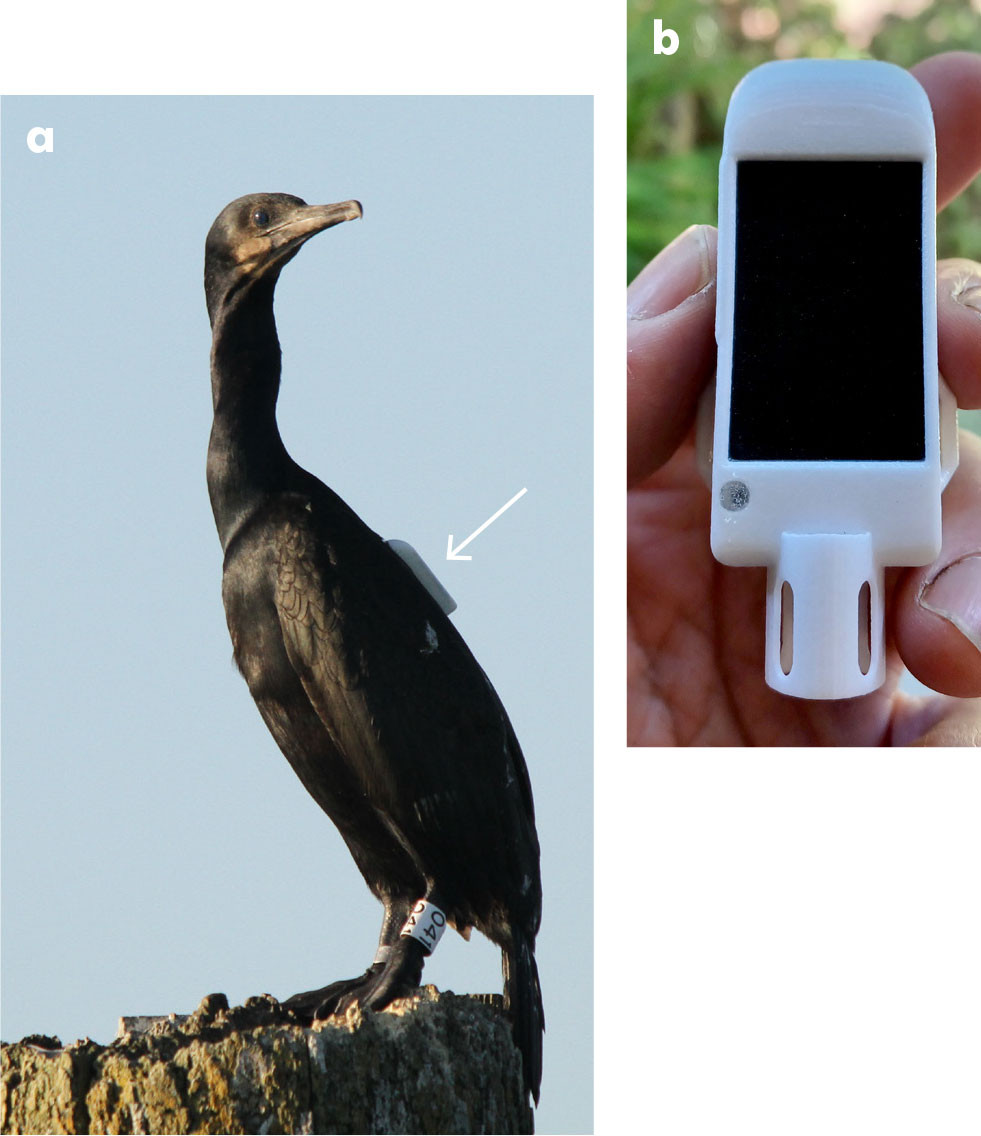
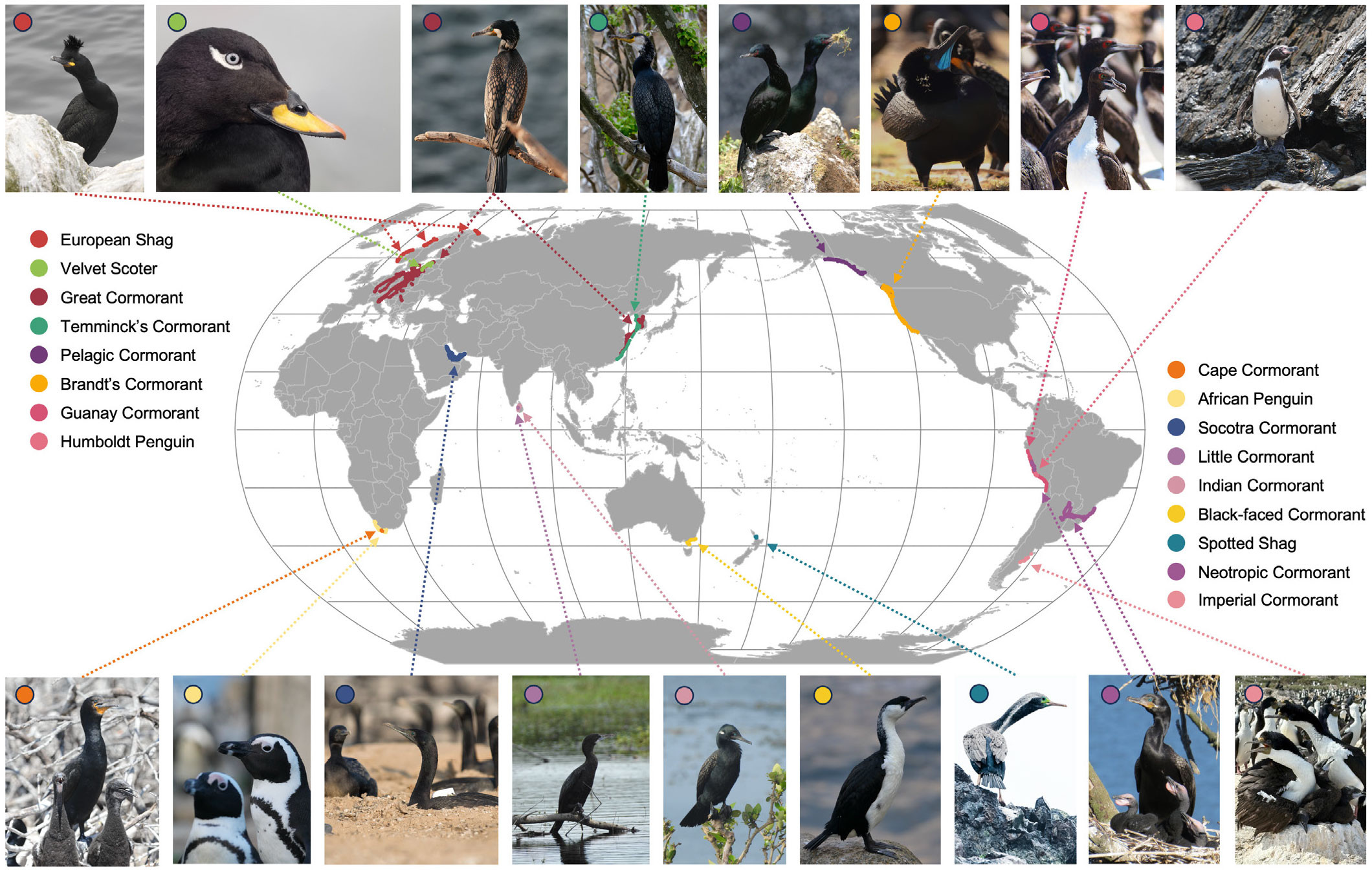
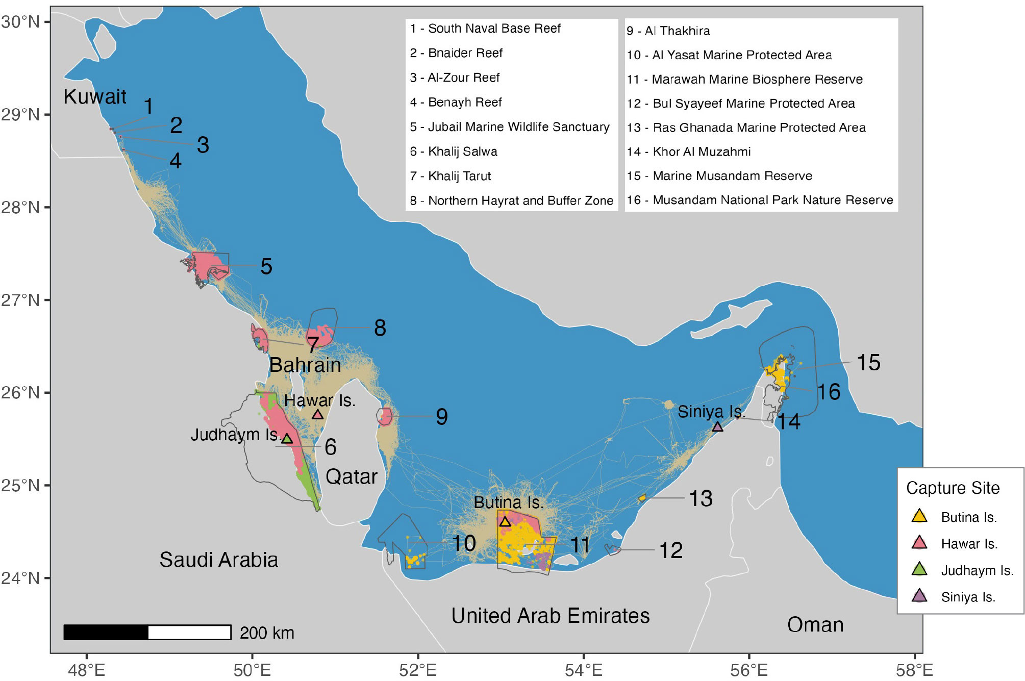
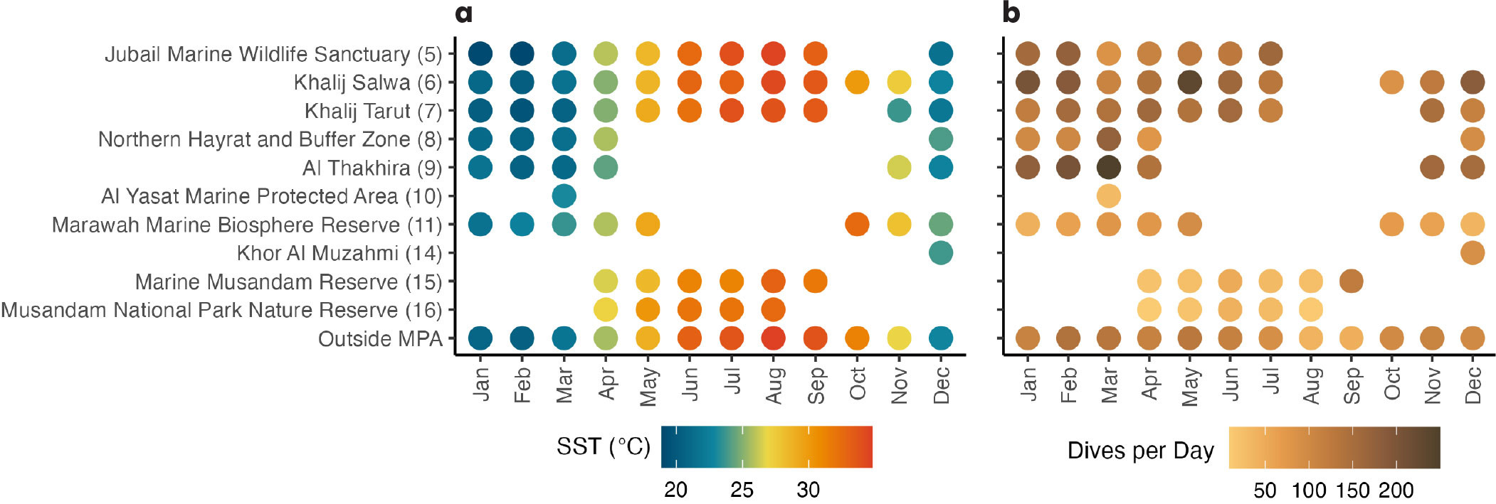
Oceanography The Official Magazine of
The Oceanography Society
Jump to
Article Abstract Full text Citation References Copyright & Usage
Article Abstract

Animal telemetry is maturing into a viable method for observing the ocean as it can be used to monitor both environmental conditions and biological metrics along the movement trajectories of marine animals. As part of the Cormorant Oceanography Project, we have augmented a biologging tag with an external fast response temperature sensor to collect ocean temperature profiles from the backs of foraging marine birds. Cormorants dive between 50 and 250+ times a day to forage for prey so they can provide hard-to-match temporal and spatial coverage of coastal ocean conditions within their foraging areas. We process tag measurements to obtain fundamental oceanographic data (e.g., temperature profiles, bottom soundings, surface current measurements). Together, we have tracked 17 marine bird species (including two Spheniscus penguins spp. and a sea duck), originating from 17 countries and foraging along the edges of all major oceans. Tagged birds’ distribution included 191 MPAs in 26 countries, offering a unique ocean monitoring method to complement more widely used methods.

Full Text

Background

Coastal oceans are complex dynamic environments, and the neritic zone supports high levels of biodiversity. It is these very complexities that make coastal ecosystems challenging to monitor at the resolutions required. Coastal ecosystems also sustain high human use and impacts, placing changes in these ecosystems at a nexus for societal relevance. Marine spatial planning and coastally located marine protected areas (MPAs) are management tools that promote the sustainable use of marine ecosystems. While most coastal MPAs are too small to encompass the year-round range of highly mobile megafauna species, small MPAs may include portions of individual ranges at key periods during the year (Conners et al., 2022). Furthermore, understanding the efficacy of an MPA to provide spatial protection for a dynamic marine environment requires monitoring of changes in both biotic and physical environmental conditions. Marine bird diet composition and demographic metrics (such as reproductive success and population trajectories) are well documented metrics of ecosystem health. Though foraging behavior is the process by which an animal expends energy to gain energy, it has not often been distilled into ocean monitoring variables (e.g., essential ocean variables [EOVs]; Harcourt et al., 2019). An understanding of environmental conditions associated with foraging is therefore a powerful ocean monitoring approach that can aid in MPA monitoring (McMahon et al., 2021).


Biologging as an Ocean Monitoring Tool

Animal telemetry, or biologging, has become a viable ocean observation tool that can be used to monitor both environmental conditions and biological metrics along the movement paths of animals (overview in Harcourt et al., 2019). Larger bodied marine animals provide free-​ranging autonomous platforms and inherently visit and revisit areas that are of importance for meeting self-maintenance and life-​history needs. Biologging employs miniaturized electronic devices to track animal movement and behavior through the use of multiple sensors (e.g., GPS, accelerometry, temperature, pressure). These same sensors can be tailored to collect relevant data on the marine physical environment. Biologging sampling offers fine-scale spatiotemporal resolution, lower costs, and the potential to sample dynamic or hard to reach areas (e.g., under sea ice; Ribeiro et al., 2021) that are challenging for other currently applied ocean monitoring methods (e.g., shipboard sampling, a single autonomous vehicle, moorings, drifters).

The type of environmental data available from biologging devices depends on the movement capacity and behavior of the animal carrying the device. For instance, deep diving southern elephant seals (Mirounga leonina) have collected temperature and salinity profiles necessary to model deep ocean currents in the Southern Ocean (reviewed in McMahon et al., 2021), while Brandt’s cormorants (Phalacrocorax penicillatus) resting on the surface between dives have documented surface currents in the Columbia River estuary that subsequently improved multivariate bathymetric modeling (Ardağ et al., 2023). Biologgers attached to benthic diving animals including seals and cormorants allow mapping of the seafloor during animals’ foraging dives (e.g., Padman et al., 2010; McMahon et al., 2023), and given how little of the ocean floor has been mapped (Tozer et al., 2019), offer a valuable, if unconventional, observing method.

Animal welfare concerns are paramount when applying a biologging approach, including species-tailored attachment, placement, and device shape, weight, and overall size. Especially for both flying and diving marine birds, tag miniaturization is key to accomplishing these goals. Over the last few decades, miniaturization has occurred in tandem with increases in the technical capabilities of tags, including their power capacities. This allows multiple data streams to be collected by one device in order to couple animal ecology studies with simultaneous collection of high-quality information on the physical and biological environment encountered by an individual animal. Flying-diving marine birds offer multiple environmental sampling opportunities, including temperature profiling during dives, seafloor mapping from benthic diving species, and surface currents and wave metrics collected when birds are resting on the surface. Furthermore, additional development of sensors will enhance the sampling capability of bird-borne biologging that could be expanded to other water column properties (e.g., fluorescence, pH, salinity) and temperature measurements (e.g., air-sea contrast).


The Cormorant Oceanography Project

As part of the Cormorant Oceanography Project, we have collaborated with a biologging company, Ornitela (Vilnius, Lithuania), to develop a customized external fast response temperature sensor to collect ocean temperature profiles from the backs of foraging marine birds (Orben et al., 2021). Additionally, customized tag programming options have allowed us to improve power management by selectively sampling during periods of activity that are both biologically relevant and key for oceanographic monitoring (e.g., dives and surface drift periods). Specifically, a GPS location fix is triggered when the bird resurfaces as the tag crosses a 1 m depth threshold. This results in a GPS fix following each dive event. Data are transferred at programmable intervals over the cell phone network (3G or 4G), allowing megabytes of data to be transmitted with each connection. Our tagging efforts focused on cormorants and shags to ensure good cell phone connectivity, as these species usually forage within 15 km of the coast and regularly return to land to roost at night. Depending on the species, we use variations of the tag type to meet the threshold of <3% animal body mass; however, typically the tag is 26 g (60 mm plus a 12 mm sensor housing × 25.7 mm x 15.4 mm) and is powered by a battery that is recharged with solar cells (Figure 1). For most cormorant species, tags are attached with a Teflon backpack harness; however, in some cases, tags were attached to feathers for shorter durations with Tesa tape (back attachment: Spheniscus penguins spp. and sea duck [velvet scoter, Melanitta fusca]; tail attachment: European shag [Gulosus aristotelis] and Cape cormorant [Phalacrocorax capensis]).


FIGURE 1. (a) A Brandt’s cormorant (Phalacrocorax penicillatus) carrying a biologging device rests on a piling in the Columbia River Estuary, USA. Photo credit: A. Peck-Richardson (b) A biologging tag fitted with a fast-​response temperature sensor and housing has proven useful. Photo credit: A. Peck-Richardson. > High res figure


Tags were customized with an external temperature sensor (TMP117, Texas Instruments, USA; ±0.1°C (maximum) from –20°C to +50°C) to measure water temperatures during dives. To estimate in situ sampling performance across a range of temperatures (10°–24.4°C), we conducted water column profiles of tags paired with a calibrated CTD (RBR Concerto CTD; Ottawa, Canada) in the Yaquina River and Estuary, in central Oregon, at five different sites along the estuary with different temperature characteristics. At each site, the CTD and biologging tags (n = 33), attached to a stainless steel frame, were lowered on a handline to depths ranging roughly from 3 m to 12 m, depending on water depth. Sensors were held near the bottom for 10–90 sec and then raised to mimic marine bird diving behavior. Five to 10 casts were made at each site. We estimated water surface temperature (SST) using the final temperature measurement of both CTD and biologging tag (1.58 ± SD 0.52 m depth). Resulting SST measurements (n = 1,160) were similar with a root-mean-squared difference of 0.21°C.


Global Monitoring of Marine Protected Areas

Together, we have tracked 17 species (14 cormorants and shags, two penguin species, and one sea duck) originating from 17 countries, and documented marine birds foraging along the coasts of all continents except Antarctica (Figure 2, as of September 2024). Some of these countries have well-developed networks of coastal MPAs (e.g., Peru, Norway, South Korea, west coast of the United States, and Canada), and while these data were collected for more general coastal ocean monitoring, tagged birds were found to occur within 191 MPAs in 26 countries (UNEP-WCMC, 2024; refined for non-overlapping management units). Most MPAs (68%) sampled in our study were small (<100 km2), but on average the protected area size was 659 ± SD 2,675 km2. The largest MPAs were used by Imperial cormorants (Leucocarbo atriceps) and located in Patagonia Azul (30,697 km2) and Frente Valdez (19,479 km2) in Argentina. The species tracked in Sri Lanka, the Indian cormorant (Phalacrocorax fuscicollis) and the little cormorant (Microcarbo niger), did not encounter MPAs. On average, birds encountered MPAs 115 ± SD 208 km from where they were originally fitted with biologging devices; the longest distance to an MPA (1,471 km) was traveled by a Brandt’s cormorant tagged in the Columbia River Estuary and tracked to southern California the following winter.


FIGURE 2. Marine bird tracking data from the Cormorant Oceanography Project (2019–2024, colored by species) surrounded by photos of birds tracked. Photo credits: Top (left to right): Nina Dehnhard, Julius Morkūnas, JinHee Lee, JinHee Lee, William Kennerley, Mike Johns, Hugo Cliff, Jose Cabello. Bottom (left to right): Eleanor Weideman, Eleanor Weideman, Sabir Bin Muzaffar, Gayomini Panagoda, Gayomini Panagoda, Thomas Cansse, Edin Whitehead, Victor Pimenta, Flavio Quintana. > High res figure


The regional distribution of the vulnerable Socotra cormorant (Phalacrocorax nigrogularis) within the Arabian Gulf, and its tendency for short-distance migratory movements (Muzaffar et al., 2017), presents a case study for how this species seasonally uses and consequently can provide samples from the physical environment within multiple MPAs. The Arabian Gulf is a shallow estuary that supports a uniquely productive tropical ecosystem fueled by nutrients supplied by seasonal dust storms and river systems running through Iraq and Iran (Piontkovski et al., 2019). Socotra cormorants are obligate marine birds and depend on the availability of schooling prey fishes (e.g., anchovy, sailfin flying fish, and blue-stripe sardines), and their movements track regional productivity (Muzaffar et al., 2017). From 2019 to 2023, we fitted Socotra cormorants with biologging devices at four colony locations within the Arabian Gulf (Figure 3a). Sixty-five birds carried devices for 231 ± SD 146 days, with 12 birds continuing to transmit data (as of August 2024). As expected, the resulting Socotra cormorant distribution was along the southern coast of the Gulf; however, individuals ranged farther than anticipated and spent time in 16 MPAs in Oman, the United Arab Emirates, Qatar, Saudi Arabia, Bahrain, and Kuwait (Figure 3a). Thus, the MPAs used by individual birds can change seasonally, and the temperatures the birds can be equipped to measure document the seasonal cycle of sea surface temperatures in their regions (Figure 4a). The number of dives made per day by each bird is an ecological variable that integrates prey availability, foraging success, and life-history needs (e.g., breeding stage; Cook et al., 2017), and it offers a metric of MPA use throughout the southern Arabian Gulf (Figure 3b), reflecting the cooler temperatures during the breeding period when birds tend to dive more frequently.


FIGURE 3. Use of marine protected areas (MPAs) by Socotra cormorants (Phalacrocorax nigrogularis) in the Arabian Gulf. All bird tracks are depicted (tan) to show movements between MPAs. Each MPA is delineated by a solid gray line and identified by number. Bird locations within each MPA are colored by the colony where birds were tagged: Butina (n = 12, yellow), Hawar Islands (n = 44, pink), Judhaym Island (n = 8, green), and Siniya Island (n = 1, purple). > High res figure


FIGURE 4. Data collected during environmental and biotic monitoring by Socotra cormorants (Phalacrocorax nigrogularis) in Arabian Gulf MPAs. (a) Average monthly sea surface temperature (SST) within and outside these MPAs calculated from biologging devices. (b) Average dives per day per bird within and outside the MPAs. Numbers following MPA names correspond to the map in Figure 3. Due to bird behavior and tag performance, dives were not recorded within all MPAs visited. > High res figure


Conclusion

Our efforts demonstrate that the coastal movements of marine diving birds can effectively sample large areas while collecting high-quality data via bird-borne biologging devices. The data derived are already proving useful for dynamic coastal ocean models (e.g., Ardağ et al., 2023). Systematic deployments in the future will make biologging devices important additions to global coastal ocean observation efforts and provide managers with another tool for monitoring ecosystem variables. Capacity building to use biologging data depends on developing user-friendly ways to transfer data. Through an automated data pipeline, we plan to provide biologging data in near-real time as well as archived data products to promote the use and reuse of these data streams. Human-wildlife conflict is problematic for many species of cormorants, as these colonial waterbirds are seen as competitors with fisheries and fish farms, can outcompete other arboreal nesting species (e.g., herons, egrets), and are often considered dirty due to intense guano deposition. More generally, marine birds are one of the most threatened groups of birds. Here, six of our 17 study species are listed by the International Union for Conservation of Nature as near threatened or higher. Biologging is one of many tools that researchers can use to provide insights for conservation and management. Continued development of high-quality, multi-sensor tags, coupled with innovative data distribution pipelines, is needed to fully benefit from and apply animal-borne sensor technology.


Acknowledgments

This work was supported by the Office of Naval Research (ONR) grant N00014-19-1-2218. Under Award N00014-13-1-0369, the ONR-funded initial work using cormorants as sampling platforms was part of the Inlet and River Mouth Dynamics DRI at the mouth of the Columbia River (MCR). Environment and Climate Change Canada provided funding for tags and fieldwork in Canada. We thank the Punta San Juan Program of Centro para la Sostenibilidad Ambiental (CSA), at Universidad Peruana Cayetano Heredia for the photographs provided by Hugo Cliff and Jose Cabello. Work with birds was approved by the Animal Care and Use Committee of Oregon State University. Permits were obtained from the respective national governments and local jurisdictions.

Citation

Orben, R.A., A. Peck-Richardson, A. Piggott, J. Lerczak, G. Wilson, J.C. Garwood, X. Liu, S.B. Muzaffar, A.D. Foster, H.A. Naser, M. AlMusallami, T. Anker-Nilssen, J.P.Y. Arnould, M.L. Berumen, T. Cansse, S. Cárdenas-Alayza, S. Christensen-Dalsgaard, A.Q. Khamis, T. Carpenter-Kling, N. Dehnhard, M. Dagys, A. Fayet, R.M. Forney, S. Garthe, S.A. Hatch, M.E. Johns, M. Kim, K. Layton-Matthews, A.K. Lenske, G.T.W. McClelland, J. Morkūnas, A.O. Nasif, G. Panagoda, J.-H. Park, V.R.A. Pimenta, F. Quintana, M.J. Rayner, T.K. Reiertsen, S.S. Seneviratne, M. van Toor, P. Warzybok, E.A. Weideman, J. Yi, Y.-T. Yu, and C.B. Zavalaga. 2025. Collaborating with marine birds to monitor the physical environment within coastal marine protected areas. In Frontiers in Ocean Observing: Marine Protected Areas, Western Boundary Currents, and the Deep Sea. E.S. Kappel, V. Cullen, G. Coward, I.C.A. da Silveira, C. Edwards, P. Heimbach, T. Morris, H. Pillar, M. Roughan, and J. Wilkin, eds, Oceanography 38(Supplement 1), https://doi.org/10.5670/oceanog.2025e115.

References
  1. Ardağ, D., G. Wilson, J.A. Lerczak, D.S. Winters, A. Peck-Richardson, D.E. Lyons, and R.A. Orben. 2023. Multivariate data assimilation at a partially mixed estuary. Journal of Atmospheric and Oceanic Technology 40(9):1,007–1,022, https://doi.org/10.1175/JTECH-D-22-0101.1.
  2. Conners, M.G., N.B. Sisson, P.D. Agamboue, P.W. Atkinson, A.M.M. Baylis, S.R. Benson, B.A. Block, S.J. Bograd, P. Bordino, W.D. Bowen, and others. 2022. Mismatches in scale between highly mobile marine megafauna and marine protected areas. Frontiers in Marine Science 9:897104, https://doi.org/10.3389/fmars.2022.897104.
  3. Cook, T.R., R. Gubiani, P.G. Ryan, and S.B. Muzaffar. 2017. Group foraging in Socotra cormorants: A biologging approach to the study of a complex behavior. Ecology and Evolution 7(7):2,025–2,038, https://doi.org/​10.1002/ece3.2750.
  4. Harcourt, R., A.M.M. Sequeira, X. Zhang, F. Roquet, K. Komatsu, M. Heupel, C. McMahon, F. Whoriskey, M. Meekan, G. Carroll, and others. 2019. Animal-borne telemetry: An integral component of the ocean observing toolkit. Frontiers in Marine Science 6:326, https://doi.org/10.3389/fmars.2019.00326.
  5. McMahon, C.R., F. Roquet, S. Baudel, M. Belbeoch, S. Bestley, C. Blight, L. Boehme, F. Carse, D.P. Costa, M.A. Fedak, and others. 2021. Animal borne ocean sensors – AniBOS – An essential component of the Global Ocean Observing System. Frontiers in Marine Science 8:751840, https://doi.org/​10.3389/fmars.2021.751840.
  6. McMahon, C.R., M.A. Hindell, J.B. Charrassin, R. Coleman, C. Guinet, R. Harcourt, S. Labrousse, B. Raymond, M. Sumner, and N. Ribeiro. 2023. Southern Ocean pinnipeds provide bathymetric insights on the East Antarctic continental shelf. Communications Earth & Environment 4(1):266, https://doi.org/10.1038/s43247-023-00928-w.
  7. Muzaffar, S.B., C. Clarke, R. Whelan, R. Gubiani, and T.R. Cook. 2017. Short distance directional migration in the threatened Socotra cormorant: Link to primary productivity and implications for conservation. Marine Ecology Progress Series 575:181–194, https://doi.org/10.3354/meps12209.
  8. Orben, R.A., A.G. Peck-Richardson, G. Wilson, D. Ardağ, and J.A. Lerczak. 2021. Cormorants are helping characterize coastal ocean environments. Eos 102, https://doi.org/10.1029/2021EO163427.
  9. Padman, L., D.P. Costa, S.T. Bolmer, M.E. Goebel, L.A. Huckstadt, A. Jenkins, B.I. McDonald, and D.R. Shoosmith. 2010. Seals map bathymetry of the Antarctic continental shelf. Geophysical Research Letters 37(21):L21601, https://doi.org/10.1029/2010GL044921.
  10. Piontkovski, S.A., W.M. Hamza, N.M. Al-Abri, S.S.Z. Al-Busaidi, and K.A. Al-Hashmi. 2019. A comparison of seasonal variability of Arabian Gulf and the Sea of Oman pelagic ecosystems. Aquatic Ecosystem Health & Management 22(2):108–130, https://doi.org/10.1080/​14634988.​2019.1621133.
  11. Ribeiro, N., L. Herraiz-Borreguero, S.R. Rintoul, C.R. McMahon, M. Hindell, R. Harcourt, and G. Williams. 2021. Warm modified Circumpolar deep water intrusions drive ice shelf melt and inhibit dense shelf water formation in Vincennes Bay, East Antarctica. Journal of Geophysical Research: Oceans 126:e2020JC016998, https://doi.org/​10.1029/2020JC016998.
  12. Tozer, B., D.T. Sandwell, W.H.F. Smith, C. Olson, J.R. Beale, and P. Wessel. 2019. Global bathymetry and topography at 15 arc sec: SRTM15+. Earth and Space Science, 6(10):1847–1864, https://doi.org/​10.1029/2019EA000658.
  13. UNEP-WCMC. 2024. “February 2024 update of the WDPA and WD-OECM,” https://www.protectedplanet.net/en/resources/february-​2024-​update-of-the-wdpa-and-wd-oecm.
Copyright & Usage

This is an open access article made available under the terms of the Creative Commons Attribution 4.0 International License (https://creativecommons.org/licenses/by/4.0/), which permits use, sharing, adaptation, distribution, and reproduction in any medium or format as long as users cite the materials appropriately, provide a link to the Creative Commons license, and indicate the changes that were made to the original content. Images, animations, videos, or other third-party material used in articles are included in the Creative Commons license unless indicated otherwise in a credit line to the material. If the material is not included in the article’s Creative Commons license, users will need to obtain permission directly from the license holder to reproduce the material.