Full Text
Marine Debris and Pelagic Ecosystems
Wood, pumice, drifting kelp, and other natural marine debris have long played important roles in marine ecosystems. Today, oceanic “litter” generated by human activities, notably plastics, constitutes the majority of marine debris and is mostly harmful to those ecosystems. In the twentieth century, plastic became a symbol of technological development and globalization of the world’s economy. Cheap, durable, and long-lasting, with a broad variety of properties that are attractive for an array of human uses, plastic penetrated all parts of business and everyday life. In recent decades, growing demand exponentially increased plastic production. Ironically, the negative environmental impacts of plastic are in part an extension of some of the very properties that make it popular, such as its durability and wide availability. Plastic degrades with time into microscopic particles that have been found in every corner of the natural world—on land, in lakes and rivers, and in the ocean. This phenomenon has led to a new description of the present era as the Plasticene: “an era in Earth’s history, within the Anthropocene, commencing in the 1950s, marked stratigraphically in the depositional record by a new and increasing layer of plastic” (Haram et al., 2020).
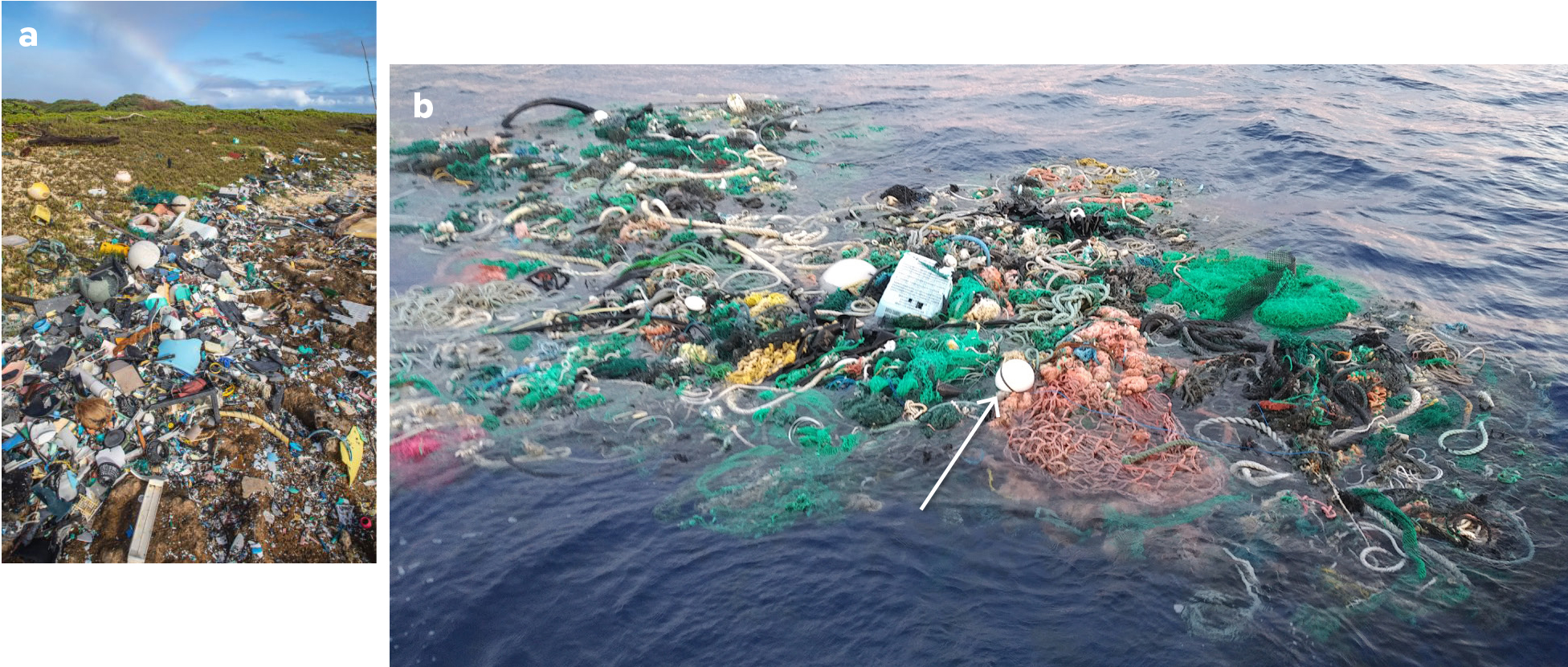
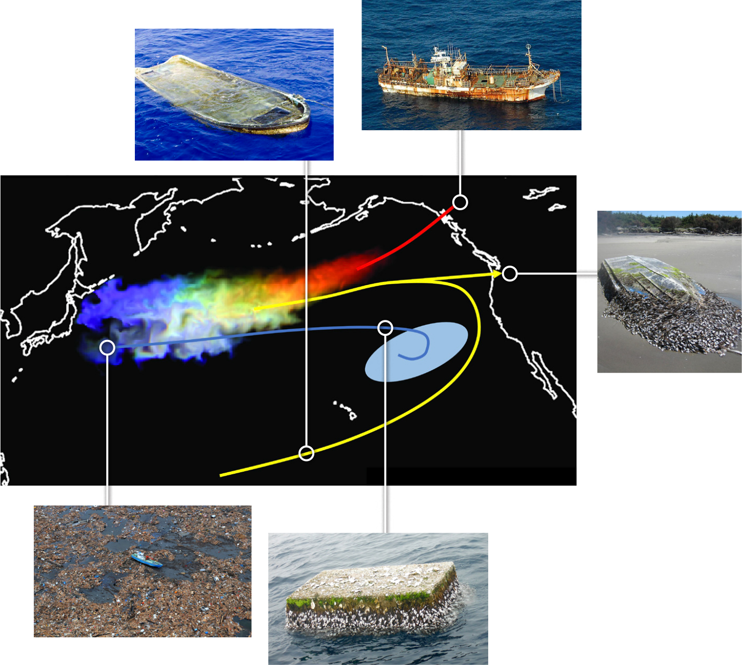
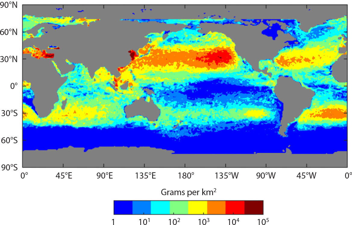
A significant fraction of plastic in the ocean has sources located on land. Depending on chemical composition, some plastic entering the ocean sinks instantly, but the majority is buoyant and remains floating at the ocean’s surface for various durations. The fate of marine debris depends on ocean currents, winds, and waves, which together move floating objects and can transport them over long distances. Some debris released into the ocean transits between distant locations and pollutes remote shorelines (Figure 1a). For example, many boats, floats, and other plastic items introduced into the ocean during the March 11, 2011, tsunami in Japan traveled thousands of kilometers to the shores of Hawai‘i and the west coast of North America (Carlton et al., 2017; Figure 2). Other debris (Figure 1b) gets trapped in convergence zones (so-called “garbage patches”) created by large-scale ocean currents in the five subtropical gyres (Figure 3), where it may remain for years or even decades.
|
|
|
|
|
|
Habitats around these convergence zones are characterized by low nutrient conditions and relatively low biological activity compared to coastal zones. A potentially important source of biomass in these pelagic ecosystems is neuston, assemblages of various species that float on or live close to the ocean’s surface (Figure 4). Neuston are moved around the ocean by physical processes similar to those that move floating marine debris, and there is theoretical expectation and observational evidence that neuston and debris follow similar pathways and accumulate in the same areas on the ocean’s surface. Little is known about interactions between neuston and marine debris, but we do know that larger biota, including marine mammals, turtles, birds, and fish that feed on neuston, can be harmed through entanglement in derelict fishing nets or by ingestion of small objects. Monitoring the status and trends of these interactions would thus benefit from an integrated monitoring approach that addresses national and/or regional policy requirements for both marine pollution and marine biodiversity.
|
|
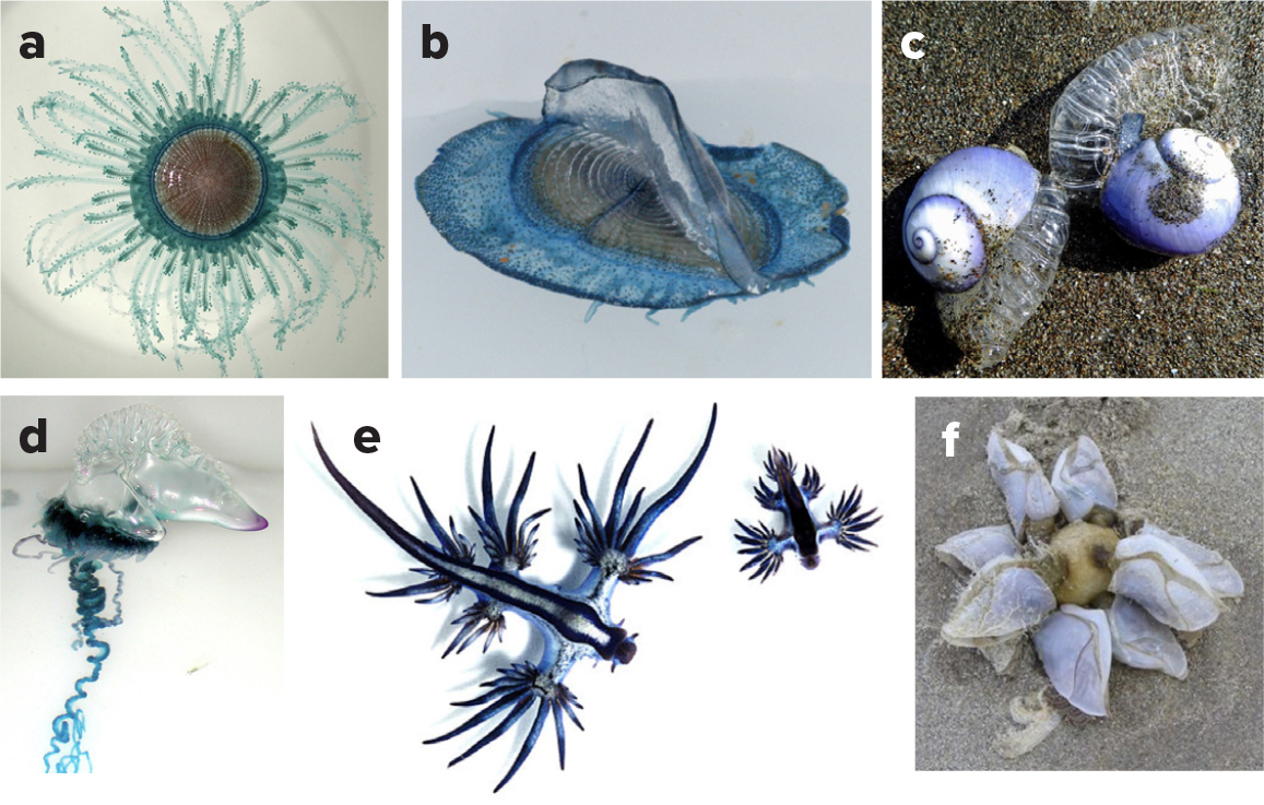
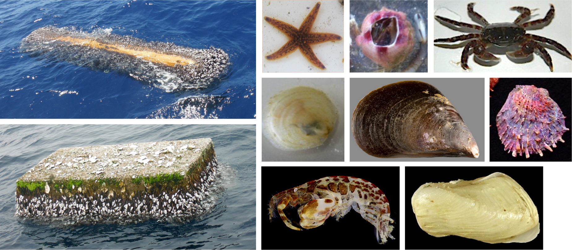
Large-scale introduction of anthropogenic debris into the ocean has triggered fundamental changes in the relative abundance of different species, species interactions, and thus energy flow. Due to the slow breakdown of plastic compared to many natural debris items, floating marine debris can be adopted as a substrate for attachment by coastal species. Where formerly there were natural barriers to the dispersal and survival of coastal biota, marine debris is providing new opportunities for them to travel across ocean basins. Feasibility of such travel was demonstrated by, among others, Carlton et al. (2017) and Hansen et al. (2018), who reported at least 373 coastal Japanese species found on tsunami debris washed up on US and Canadian shorelines (Figure 5). Moreover, Haram et al. (2021) discovered that the high concentration of marine debris in the North Pacific Garbage Patch now allows coastal species to establish and reproduce there, creating a neopelagic ecosystem. This system may then further facilitate potential biological invasions into coastal areas. It is also suggested that degrading plastic debris may release carbon accessible to marine microbes that in turn could alter the entire food web (Romera-Castillo et al., 2018).
|
|
The need to significantly reduce the amount of plastic in the ocean is recognized by the United Nations (UN) as Sustainable Development Goal (SDG) Target 14.1: “By 2025, prevent and significantly reduce marine pollution of all kinds, in particular from land-based activities, including marine debris and nutrient pollution.” The UN Environment Programme (UNEP) provides a guide for compiling pollution indicators, including Indicator 14.1.1b on plastic debris density, whose measurements will require combining traditional monitoring techniques with new technologies and data science (UNEP, 2021). Addressing critical knowledge gaps around the fate of marine plastics and other debris and their impacts on marine ecosystems requires coordinated, multidisciplinary, large-scale observations of marine debris in the ocean. This effort will be made possible through close integration with the Global Ocean Observing System (GOOS; https://www.goosocean.org), which already coordinates a global system of ocean observing platforms (e.g., ships, buoys, satellites, autonomous vehicles) that provides essential information on ocean physics and climate, biogeochemical cycles, and biological and ecosystem processes.
Novel Approaches to Monitoring Marine Debris and Associated Pelagic Ecosystems
Collecting comprehensive observations of marine debris and marine life in the pelagic ocean is tremendously difficult. Pelagic ecosystems contain diverse species, each having its own life cycle and each responding differently to changing environmental conditions. Interactions among species produce an even larger number of monitoring and research challenges. Similarly, marine debris objects vary broadly in their chemical (e.g., polymers, additives, and degree of degradation) and physical (e.g., size, geometry, and buoyancy) properties. In addition to plastic, marine debris includes other artificial materials as well as debris linked directly to human activities (e.g., logging) or natural disasters (e.g., floods, hurricanes, or tsunamis).
Given limited scientific resources available in the open ocean and patchy distributions of marine debris items and pelagic species, it is critical to develop and implement effective observational tools that target specific scientific questions or applications, including the following:
- How much anthropogenic and natural debris is in the ocean?
- What are the physical and chemical compositions of the debris?
- What are the main sources, pathways, spatial patterns, and areas of impact on marine ecosystems?
- What is the composition of neopelagic communities, what environmental variables control species’ life cycles, and how do they interact with plastic debris?
- What changes take place in marine ecosystems relative to the distributions of marine debris and how are they related to natural variability and ongoing climate change?
- What is our capacity to predict these changes?
Water-Following (Lagrangian) Instruments
Drifters (oceanographic instruments that are composed of a surface float tethered to a drogue) and subsurface floats are actively used to measure ocean currents, an essential ocean variable. For example, the Global Drifter Program (https://gdp.ucsd.edu/ldl/global-drifter-program/) maintains a network of more than 1,300 drifters covering all ocean basins. Drifter trajectories can be used as a proxy for pathways of marine debris and neuston and to estimate drift velocities. By using standardized designs for drogued and undrogued drifters (Figure 6), their responses to various ocean conditions can be understood and their data used to improve numerical ocean models, which help us to understand the many ways in which the ocean influences weather and climate. Studies establishing correspondence between the dynamics of standard drifters and different types of debris and biota are underway, and new types of drifters may be needed to reproduce pathways of particular debris types, such as fishing nets. A great deal of information on ocean surface currents is also captured through satellite measurements that allow for integration of products from multiple satellite missions.
|
|
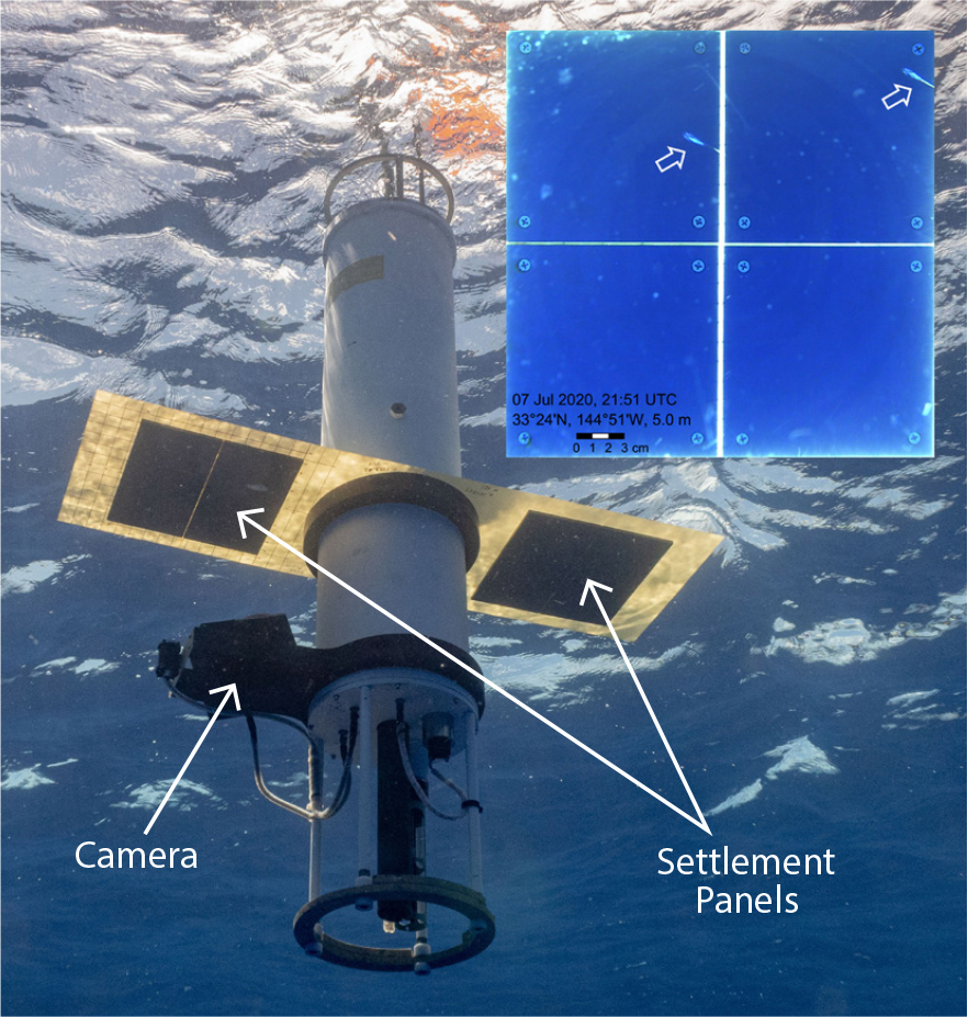
Some types of marine debris, such as microplastics and items that contain a lot of biological growth, have weak buoyancy. They are easily mixed downward into the water column by wind-induced turbulence and may remain below the surface. Similarly, some neustonic species may have pelagic life-cycle stages that exist below the surface waters. With the commonly strong vertical shear of near-surface currents, these vertical movements can significantly affect the horizontal transport of debris and neuston. Understanding these effects is a difficult task given that existing methods do not allow us to follow submerged objects. However, scientific instruments can be programmed to mimic the dynamics of debris or the lifecycle of certain biota. For example, the buoyancy of a mixed layer float that was used in the National Aeronautics and Space Administration (NASA) funded FloatEco (Floating Ecosystem) experiment (Figure 7; https://floateco.org) could be carefully calibrated under varying ocean conditions. Timelines of its residence in the mixed layer of the ocean can be analyzed and compared with vertical profiles of microplastics.
|
|
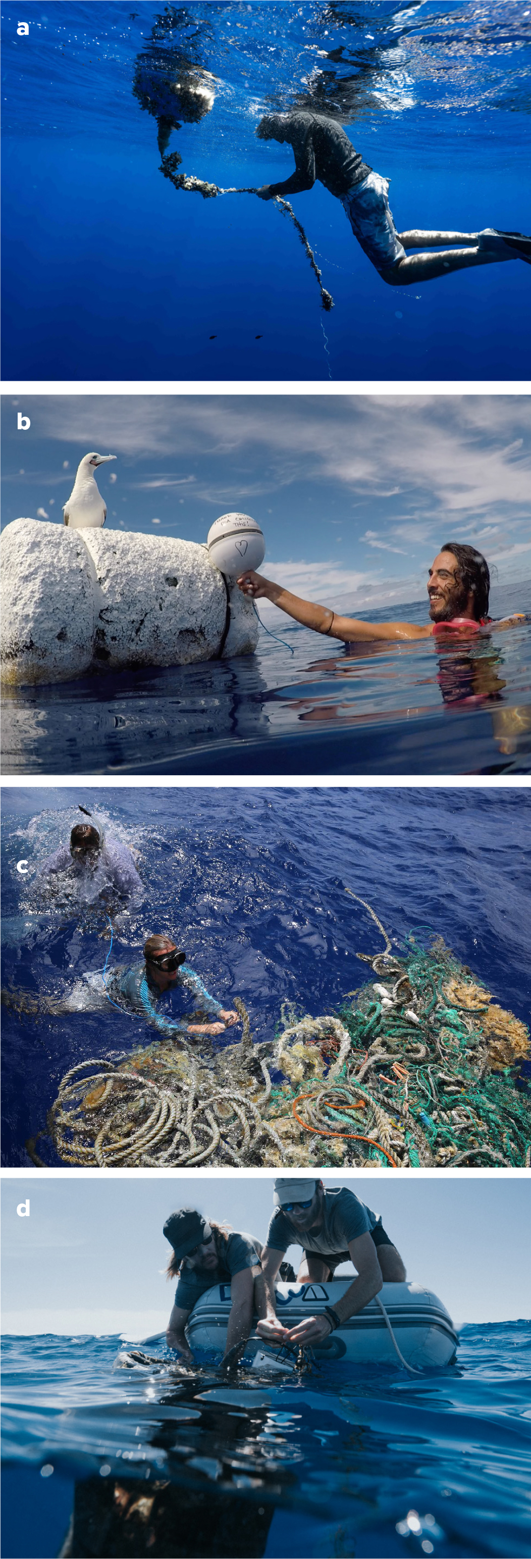
New methods also allow scientists to track selected large objects. For example, since 2018, the Ocean Voyages Institute (OVI; https://www.oceanvoyagesinstitute.org/) has operated dozens of Global Positioning System (GPS) trackers (Figure 1b), the majority of them attached to derelict fishing gear, the most harmful marine debris. The trackers have helped OVI collect hundreds of tons of derelict fishing gear and provided unique data for scientific research on the dynamics of floating debris.
Field Sampling
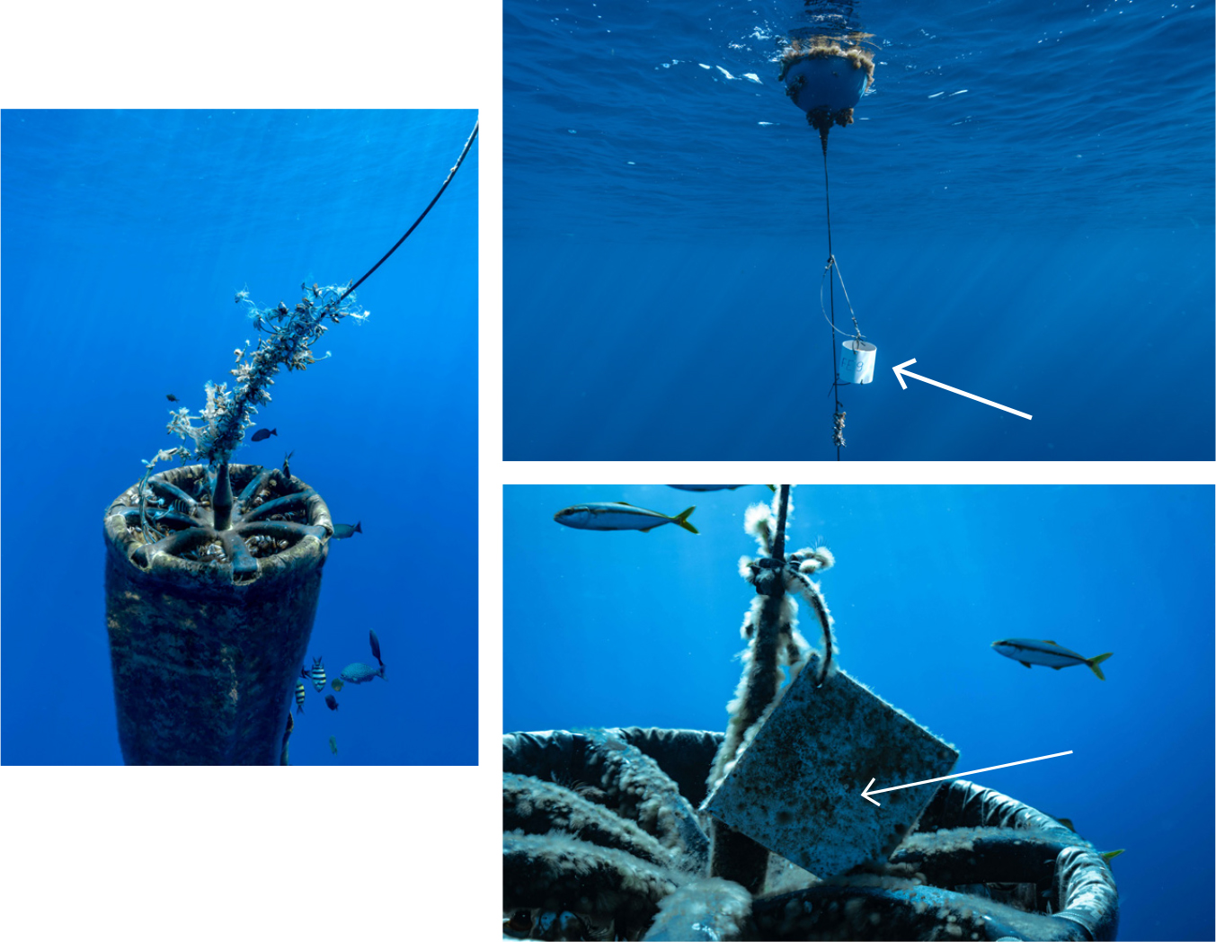
In situ samples are critical for monitoring marine ecosystems and marine debris distributions, validating models, and testing scientific hypotheses. To produce high-quality and timely data on marine debris and biofouling as well as neustonic biota, existing observing systems must be strengthened and complemented with new methods and platforms. In some cases, significant progress can be achieved through coordination among existing observing programs and adjustments to protocols to integrate observations of debris and associated biology. For example, settlement panels (typically simple, square PVC tiles) can be attached to debris to provide information such as the rate of colonization and the community structure of colonizing species (Figure 8b). Use of such panels together with drifters and floats (Figures 6 and 7) opens opportunities for advanced scientific experiments designed to address important questions of biological-physical interactions among species, their biogeography, and how species are responding to global changes.
|
|

Citizen Science
Scientific expeditions are expensive and often have a narrow focus. At the same time, science plays an ever-increasing role in society, partly through non-scientists’ growing accessibility to cutting-edge scientific resources. Engagement with the public in science is supported by national and international programs (e.g., https://science.nasa.gov/citizenscience; https://citizenscience.org/) and creates opportunities to fill important gaps in our observing systems. Also, as stakeholders, citizen scientists inspire important new applications that require support with observational data.
Recent successful cooperation with the ocean sailing community allowed for microplastic sampling over large areas of the ocean (Tanhua et al., 2020). Another remarkable example of reciprocal work between scientists and citizen scientists is the collaboration between the FloatEco team and OVI. OVI deployed and retrieved instruments operated by the FloatEco team and collected a representative set of samples of biofouled marine debris (Figure 8). In turn, FloatEco helped OVI to optimize operations by using numerical models and mobilizing additional volunteers who tagged debris with OVI’s GPS trackers (Figure 9b,c). Haram et al. (2021) highlight this collaboration, which has developed into the GO-SEA program (https://goseascience.org/), a new NASA-affiliated project that serves to expand the connections between community members and scientists by including sailors and beachgoers in its network. Development of observational protocols and methods for sample collection, preservation, and measurements will further increase the contributions of volunteers to scientific studies.
|
|
The large “beachcomber” community can play an important role in documenting marine debris and biota stranded on shorelines. Reports collected through platforms such as iNaturalist (https://www.inaturalist.org/) can further reveal what is floating on the open ocean and timelines for its arrival ashore. If synthesized with numerical models and satellite images, debris observations from coastal community members can also inform our understanding of ocean circulation patterns as well as debris and neuston trajectories, yielding further insight into processes taking place far from the coast. New, exciting approaches combining citizen science macro- and microplastic sampling with simultaneous monitoring of marine debris and automatic sensor observations of physical and biochemical essential ocean variables have the potential for further expansion of interaction studies between marine plastic pollution and neuston.
Standardization and Automation of In Situ Observations
Because marine debris and biota have complex compositions, full protocols of observations and data collection are also complex, and processing of samples and data in the laboratory is labor intensive. The community needs to agree on standard protocols for sampling and laboratory analytical methods to allow comparison of data collected during different campaigns. One possible way to significantly increase the data flow is by developing sensors and systems that can operate autonomously and generate large volumes of data with consistent format and quality. Once available, such sensors and systems could be used on ubiquitous platforms, such as commercial ships, as well as autonomous vehicles (such as drones and gliders).
Remote Sensing
Because of the patchiness of floating debris and pelagic marine communities, satellites are the only platforms capable of capturing the “big picture.” They are critical tools for observing the most inaccessible regions of the ocean and detecting anomalies in near-real time. Space agencies and groups have expressed great interest in this new application of remote sensing. The Portugal Space Agency (https://www.moonshotchallenge.ai/) and NASA recently funded several exploratory projects, and the schedule of Sentinel-2 operated by the European Space Agency (https://sentinel.esa.int/web/sentinel/missions/sentinel-2) was changed for July–September 2021 to include the area of the North Pacific Garbage Patch. Additionally, the International Ocean Color Coordination Group has created a Remote Sensing of Marine Litter and Debris Task Force (https://ioccg.org/rsmld-news-and-updates/). More and more projects report test results, in which pre-set targets have been successfully detected by drones and/or satellites, including patches of mixed floating debris in coastal waters (Figure 10). Signals from marine debris and biota are often co-located in satellite images due to biofouling or concentration of debris, neuston, and/or macroalgae in ocean slicks and other phenomena. Laboratory studies and machine learning further support the feasibility of remote-sensing applications. However, much more effort will be required to build on these early successes. Difficulties remain partly because all existing satellites were designed and built for very different applications, without marine debris or biodiversity detection in mind.
|
|

Development of new remote sensors is important because often the same technology can be replicated on many scales, from satellites to suborbital platforms, shipborne systems, drones, hand-held tools, and even in situ sensors. These sensors will generate unique opportunities for intercalibration and interscaling of data products.
The Way Forward: Integration and Coordination of Observational Resources
The complexity of marine debris composition and associated biological communities, as well as the diversity of tools and methods available to monitor and observe them, require coordinated approaches that harmonize regional efforts into a global system without losing the collection of any important indicators. At the OceanObs’19 conference (https://www.oceanobs19.net/), a large group of experts from many disciplines proposed the concept of an Integrated Marine Debris Observing System (IMDOS) that would mobilize all available resources to work together to provide a hierarchy of data products and applications needed by stakeholders (Maximenko et al., 2019). The envisioned system combines in situ observations and sampling, providing calibration of indirect information and validation for models, with remote sensing yielding a big-picture view and models optimizing and interpreting field observations and forecasting future changes.
Considering that critical knowledge gaps exist around the cycling of marine debris in the ocean and the interaction of marine debris with various ecosystem components, further IMDOS development will include better integration of marine debris monitoring with biogeochemical, biological, and ecosystem observations (including biodiversity and ocean health indicators) coordinated by GOOS and the Marine Biodiversity Observation Network (https://marinebon.org/). Successful integration depends on identifying common requirements for observed variables including accuracy and spatiotemporal resolution, sharing platforms, and augmenting sampling protocols, as well as harmonizing data streams across disciplines.
GOOS coordinates a large network of ship-based, fixed-point, autonomous, and other platforms that monitor the open and coastal oceans, but its potential for measuring marine pollution remains strikingly underutilized. There is potential for co-located oceanographic (both surface and water column) observations of marine debris; co-designed environmental monitoring of marine habitats (e.g., seagrass and macroalgae) with seafloor debris surveys; or better interfacing the rapidly evolving capacity of remote-sensing detection with environmental monitoring to expand and validate modeling and scientific assessments toward informed decision-making.
GOOS aims to support the community in establishing IMDOS as a backbone observing system for delivering data to strengthen scientific knowledge about marine debris pollution. In particular, the aim is to establish a globally coordinated network that observes debris floating on the ocean’s surface. The envisioned observing network will build on global harmonization of monitoring methods and data sharing initiatives supported by the Japan Ministry of the Environment and G20 countries. It will consider viable observing methods and platforms following GESAMP Working Group 40 (http://www.gesamp.org/work/groups/40) guidelines as well as the feasibility and cost analysis of augmenting existing standard operating protocols of relevant GOOS observing networks. The network’s status, progress, and performance could be visualized through the OceanOPS real-time dashboard and toolbox (https://www.ocean-ops.org/board). The network would also bring together different citizen science initiatives aimed at collecting observations of debris and associated biota from non-commercial (i.e., sailing and other recreational) vessels. This activity will further be included in the larger cooperation effort led by OceanOPS within the UN Ocean Decade project Odyssey.
Many components of a future IMDOS are already being implemented, although global coordination of these efforts has not yet been achieved. Advances include expanding collaborations among remote-sensing and in situ monitoring groups and among scientists and environmental groups, harmonizing and standardizing methods of marine debris sampling and monitoring (e.g., https://www.euroqcharm.eu/en for microplastics), developing global data synthesis products enabled by the growing number of international databases (e.g., Isobe et al., 2021) and experiments such as FloatEco, and implementing new sensors (e.g., https://www.oceandiagnostics.com/).
As the United Nations Decade of Ocean Science for Sustainable Development (2021–2030) focuses attention on ocean health, the development of interdisciplinary connections between scientists, the public, and other stakeholders will allow the community to identify and act upon the most important issues associated with anthropogenic marine debris.
ACKNOWLEDGMENTS