Full Text
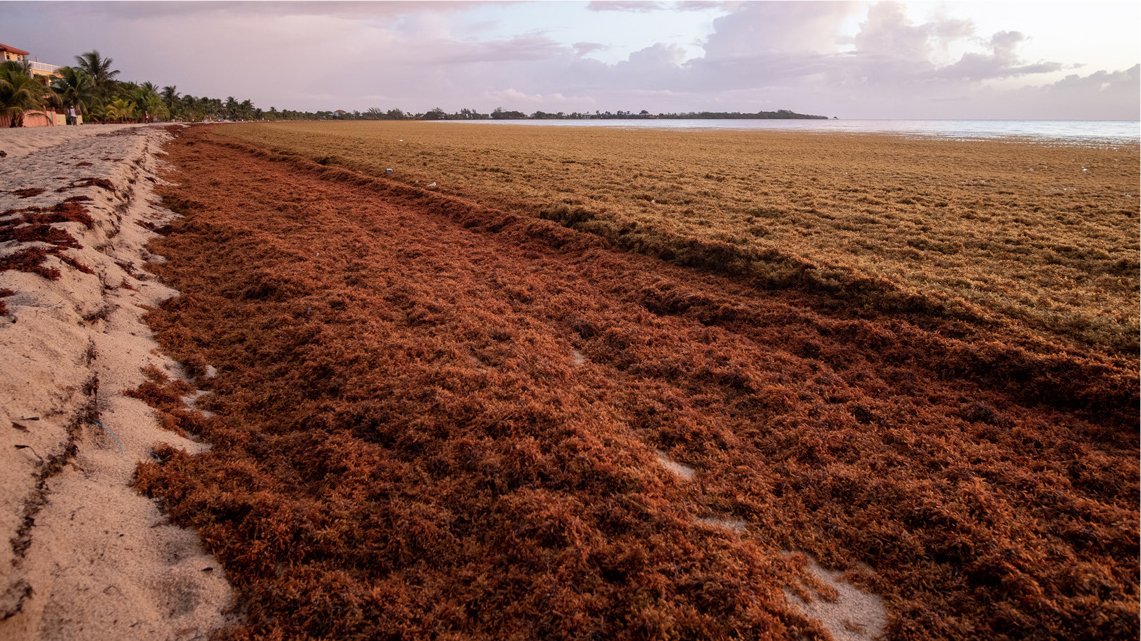
The floating, golden-brown algae, pelagic Sargassum, plays an important role in the marine ecosystem of the North Atlantic, and depending on its extension and impact, has the potential to be considered a pollutant. In the open sea, it provides a habitat to numerous fish and other species and represents a highly productive ecosystem in an otherwise low-nutrient environment. However, following an apparent regime shift in 2011, large amounts of Sargassum have entered the Caribbean Sea, mostly from the tropical Atlantic, washing ashore in massive amounts (Figure 1). These seasonal events have negatively affected the economies of the region's island nations, which are largely driven by tourism and, to a lesser extent, fishing. The vast amounts of Sargassum may also cause problems for human health (e.g., arsenic concentration), marine navigation, and coastal ecosystems. Monitoring inundation events relies on a combination of in situ and remote-sensing data that have been specifically designed to detect Sargassum and are used to inform numerical models that help predict the extent, amount, and movement of these algae. Interoperable tools for data distribution, information management, and visualization are critical to ensure data, and results from monitoring and predictions, are readily accessible. Such a framework would benefit essential economic, social, and environmental domains and would define the baseline needed to coordinate future science-driven monitoring and evaluation efforts, including contributions toward eventual sustainable commercial exploitation/reuse of Sargassum.
|
|
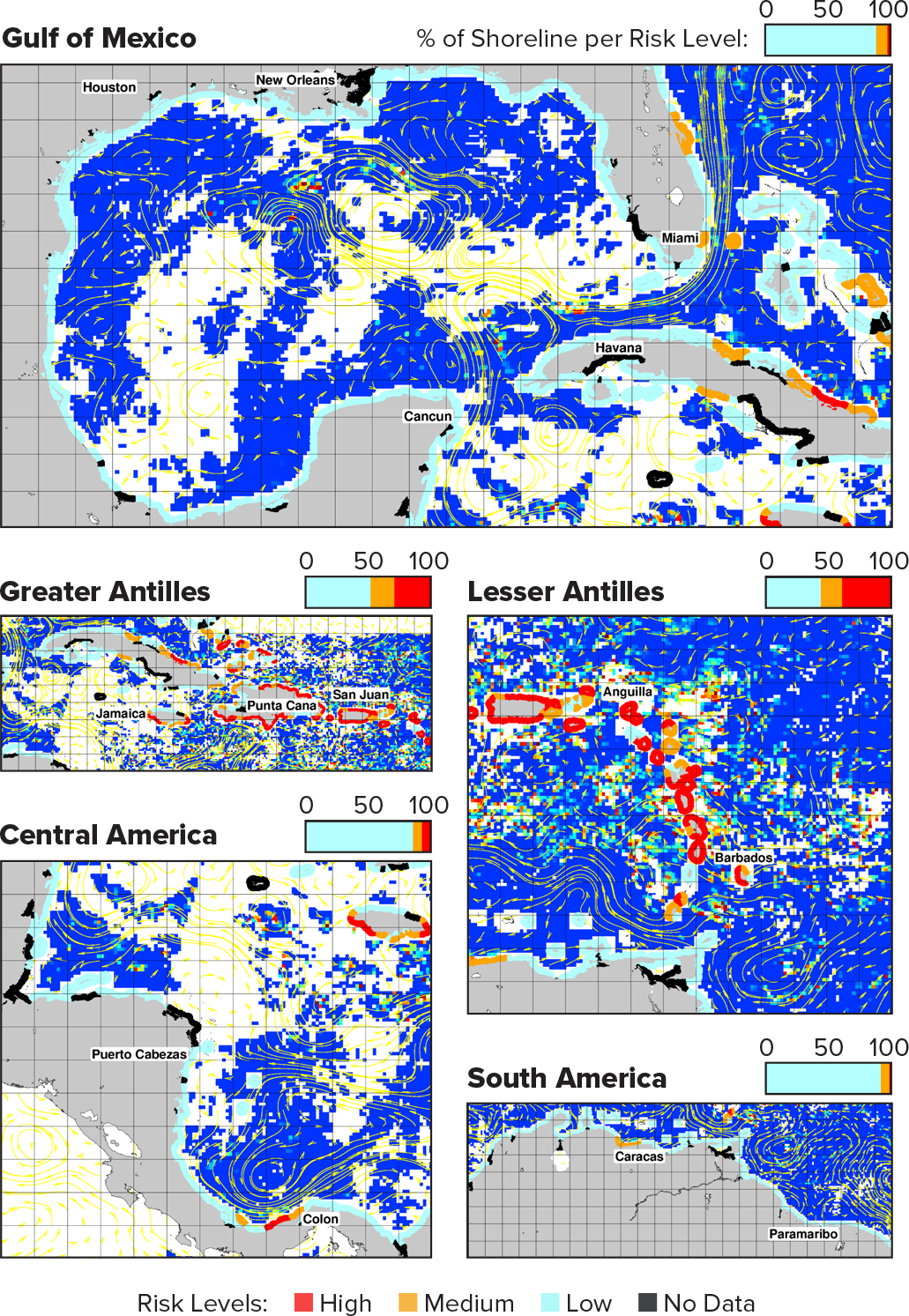
The complicated dynamics of Sargassum render routine monitoring using ships to collect in situ observations at the scale of the North Atlantic, or even the Caribbean Sea, far from practical. In contrast, satellite sensors can simultaneously observe Sargassum across wide swaths of ocean. Detection of pelagic Sargassum by satellite sensors usually relies on the measurement of red-edge reflectance using bands in the red and near-infrared. Pioneering research by James Gower and Chuanmin Hu led to the development of indices, such as the Maximum Chlorophyll Index (MCI) and the Alternative Floating Algae Index (AFAI), for detecting Sargassum (Figure 2). Similar products (e.g., using the Sentinel-2 Multispectral Instrument) are being developed to improve the coverage in coastal areas, where higher-resolution data are needed to monitor Sargassum). Several monitoring efforts are assessing the abundance of Sargassum in the open ocean and in coastal areas (Hu et al., 2016; Triñanes et al., 2021). Open and unrestricted access to near-real-time and historical MCI/AFAI data are provided by the University of South Florida’s Sargassum Watch System and the National Oceanic and Atmospheric Administration (NOAA) Atlantic OceanWatch. These data contribute to summaries designed to inform regional stakeholders and include the broad-scale monthly Sargassum Outlook Bulletin and a higher-resolution weekly coastal Sargassum Inundation Report (SIR) (Figure 3).
|
|
|
|
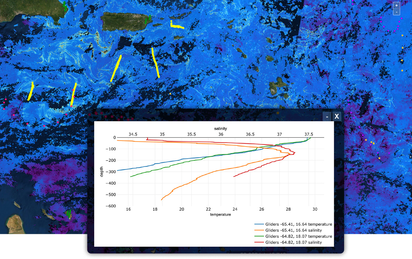
The validation of Sargassum satellite products benefits greatly from the integration of in situ data over the regions of interest. NOAA maintains a database that collects digital photos and written descriptions of Sargassum from several repositories, including citizen science projects organized by NOAA, Epicollect5, and SPAW/USF. Additionally, in situ research is being conducted by NOAA’s Atlantic Oceanographic and Meteorological Laboratory to better predict how objects like Sargassum move at the ocean surface. GPS tracking devices have been affixed to Sargassum mats and to drifters of various shapes, sizes, and buoyancies (some of which were designed to mimic small patches of pelagic Sargassum), and their tracks have then been examined relative to ocean conditions (Miron et al., 2020). Analyses indicate that combining information on surface currents, winds, and the physical properties of the objects (Sargassum rafts) improve predictions of Sargassum movement and thus can contribute toward the development of forecast risk models.
The popularity and adoption of technologies, architectures, and processes linked to big data, cloud computing, machine learning, business intelligence, data integration, and service-oriented architectures (SOAs) represent an opportunity for the design and implementation of a Sargassum Information Hub. The increasing availability of data (structured, semi-structured, and non-structured), the user and system requirements (in terms of, e.g., security, cost, data quality, data performance, data analytics, visualization, usability), the variety of technologies, and the data integration processes must be assessed and managed to ensure they align with user goals and strategies. Under the current scheme, most of the Sargassum products are available through interoperable middleware, such as ERDDAP and THREDDS Data Server. Machine learning algorithms are being increasingly applied to create a new generation of products that use heterogeneous and multimodal data (e.g., satellite fields at different resolutions, vector and raster inputs). For visualization purposes, online mapping applications (e.g., OceanViewer) provide multipurpose, scalable, and easily accessible platforms for displaying and analyzing spatial data. The goal is to integrate data from multiple sources (including models) and use SOA-based Spatial Data Infrastructure to provide services to all stakeholders across government, academia, industry, and civil society. A pilot project led by IOCARIBE (a sub-commission of UNESCO’s Intergovernmental Oceanographic Commission), the Association of Caribbean States, NOAA, GEO Blue Planet, and other partners from government agencies, intergovernmental initiatives, and academia, is underway to lay the foundation for monitoring Sargassum with the goal of enhancing the response to Sargassum influxes by developing an early warning system and improving forecasting.