Full Text
Tropical cyclones and other extreme coastal storms cause widespread interruption and damage to meteorological and hydrological measurement stations exactly when researchers need them most. There is a longstanding need to collect collocated and synchronized measurements in areas where storms severely damage civil/coastal infrastructure. To fill this observational gap, researchers led by author Masters developed a state-of-the-art monitoring station called a “Sentinel.” Sentinels are intended for temporary installation on the beach between the mean tidal datum and the sand dunes and are engineered to operate in and measure extreme wind, storm surge, wave, and hazardous water quality conditions. They are envisioned as a shared-use resource—a hardened Internet of Things platform set up in the right place at the right time to study wind and wave loads, coastal erosion and morphology changes, water quality, and other processes during extreme coastal storms.
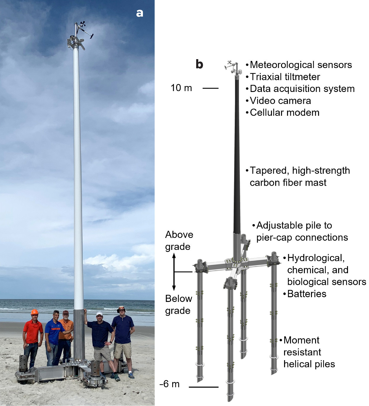
In 2021, a fully functional prototype Sentinel (Mark I) was designed and built through internal support and industry contributions. The structure is engineered to survive a design wind load of 90 m s–1 (3 sec gust measured at 10 m above ground level) in marine exposure, 5 m breaking waves in 5 m still water with a wave celerity (the propagation speed of a wave crest or trough) of 6.7 m s–1, and 1 m of combined erosion and pile scour. The structure anchors to the beach using four 200 mm diameter steel helical piles driven by a hydraulic auger. The piles are segmented such that four sections can reach an embedment depth of 6 m for the worst-case design load. The piles support an adjustable aluminum alloy “crossbeam” pier cap that in turn supports a 10 m tall carbon fiber mast. Three-dimensional wind velocity, mast tilt, atmospheric pressure, temperature, and humidity data are collected at 10 Hz at the top of the mast, along with video. The upper instrumentation package makes up the “nerve center” for the system and includes a data logger and cell modem. The base houses batteries and a wave/water depth, temperature, and salinity sensor (sampled at up to 5 Hz) that connects to the upper instrumentation package. Figure 1b shows the Mark I design. A field test was completed in October 2021 (Figure 1a) to identify logistical challenges and areas for improvement in future Sentinel versions.
|
|
In 2022, authors Phillips, Masters, Raubenheimer, Olabarrieta, Morrison (co-PI), Ferraro, and Davis received a National Science Foundation (NSF) Major Research Instrumentation (MRI) award to support the design of a Mark II Sentinel and the commissioning of a fleet of six Mark II Sentinels. Mark II will improve on Mark I in several key areas: (1) the deployment conditions will expand beyond tropical cyclones, (2) the pile installation system will accommodate non-cohesive and cohesive soils as well as layers of harder geomaterial, (3) the structural loads will be revisited through field and laboratory studies, (4) the structural design will be further optimized to reduce weight and installation time, and (5) additional sensor packages will be explored for measuring erosion, water current, and a suite of water quality parameters. Design work on the Mark II is underway.
As tropical cyclones approach, Sentinels will be installed one to three days before landfall. The project is supported by the SHared Operational REsearch Logistics In the Nearshore Environment (SHORELINE) Network, a national collaboration represented by universities in hurricane-prone states. Through SHORELINE, an array of pre-selected sites and permits are maintained along the Gulf of Mexico and the Atlantic coasts. Ad hoc site approvals are also pursued based on expected landfall locations. Selected sites are locally surveyed using a radiodetection meter and a ground penetrating radar to avoid installation of piles in bearing strata containing underground objects. With input from conservationists, the team avoids selecting sites near nesting grounds for sea turtles, shorebirds, and other species. Installation time is anticipated to be several hours based on field tests, and the installation process takes into account deteriorating weather conditions. Sentinels will be removed after the team can safely return to the deployment sites.
Sentinels are designed to continuously transmit live data and video feeds over cellular networks. During an event, data and video are intended to be shared with a broad spectrum of research, operational, and commercial partners as well as interests supporting local response and recovery (e.g., emergency management and state departments of environmental protection or natural resources). Post-event data sets will be made publicly available through NSF’s DesignSafe Data Depot (https://www.designsafe-ci.org/data/browser/public/; Rathje et al., 2017). These stations will support fundamental research that includes but is not limited to numerical weather prediction, storm surge and shallow wave modeling, coastal erosion, boundary layer meteorology, air-sea interaction, biogeochemistry, aircraft- and satellite-based remote sensing of surface wind and wave fields, and hydrodynamic loading of coastal structures.
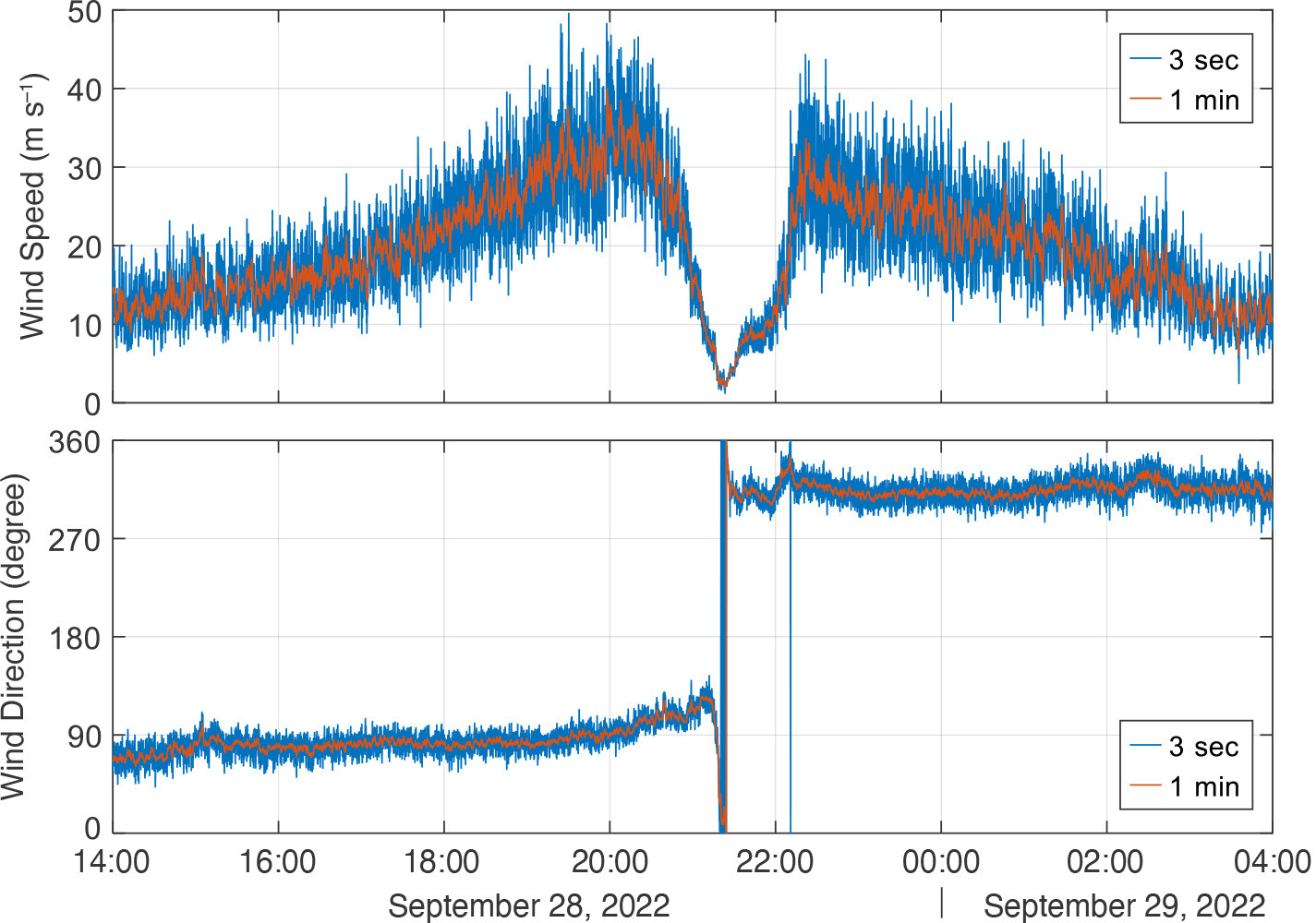
The Sentinel Project is a culmination of more than two decades of conducting field data collection in landfalling tropical cyclones (Fernández-Cabán et al., 2019). The University of Florida, through the Florida Coastal Monitoring Program (FCMP), has continuously conducted field experiments in landfalling storms since the late 1990s (40 storms to date, including more than 10 major hurricanes). Example data from an FCMP weather station is shown in Figure 2. Sentinel weather stations are complementary to FCMP with a focus on beach deployments. The team anticipates deploying three Sentinels in 2023 and several more in the 2024 hurricane season.
|
|