Full Text
Faced with a declining summer sea ice extent, enhanced warming relative to the rest of the globe, altered ecosystem dynamics, shifts in circulation and hydrological patterns, amplifying feedbacks, and potential looming tipping points, the Arctic system is in a transitional state that is at the epicenter of global climate change. As the Arctic transforms, we are challenged to understand the processes involved and to construct the tools and models that will help us predict and manage those changes as they continue to evolve in coming decades. It is upon this backdrop of rapid change that the Multidisciplinary drifting Observatory for the Study of Arctic Climate (MOSAiC 2019–2020) expedition ventured into the central Arctic sea ice (Shupe et al., 2020). It was an expedition to collect sorely needed observations and to examine the changing Arctic in a new way, with an unprecedented level of detail.
An international team of leading climate scientists designed the expedition to understand the fundamental question: What are the causes and consequences of an evolving and diminished Arctic sea ice cover? While sea ice was the central integrator, MOSAiC was very much a coupled system study reaching across disciplines and domains. Drawing upon the expertise of many nations, it examined the physical, chemical, and biological processes that link the atmosphere, sea-ice, ocean system, both driving and responding to the massive changes that are underway.
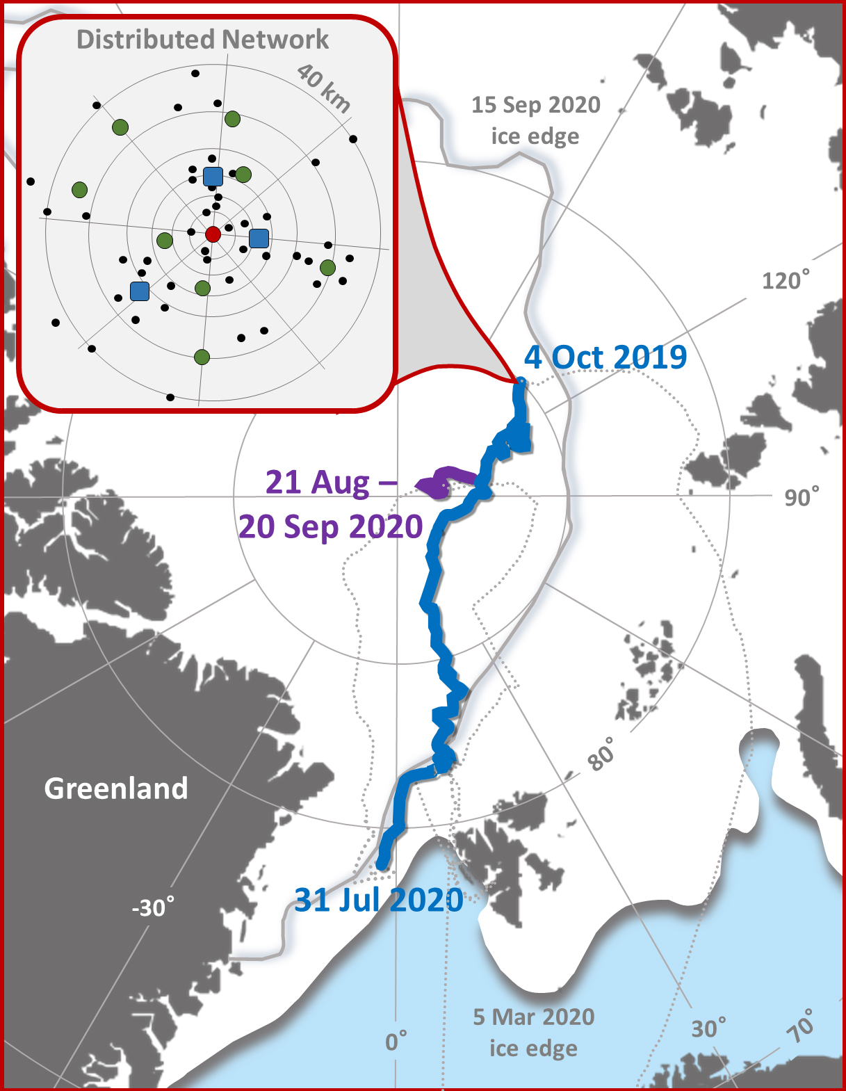
Following years of planning, preparation, and coordination, eager MOSAiC scientists embarked on the German research icebreaker Polarstern in September 2019, bringing with them an extensive collection of sophisticated instrumentation, extreme weather gear, and observational strategies. After finding a suitable ice floe north of the Laptev Sea, Polarstern’s propulsion engines were shut off and the vessel was set to drift passively with the sea ice along the Transpolar Drift (see Figure 1), following in the footsteps of Fridtjof Nansen more than 125 years prior.
|
|
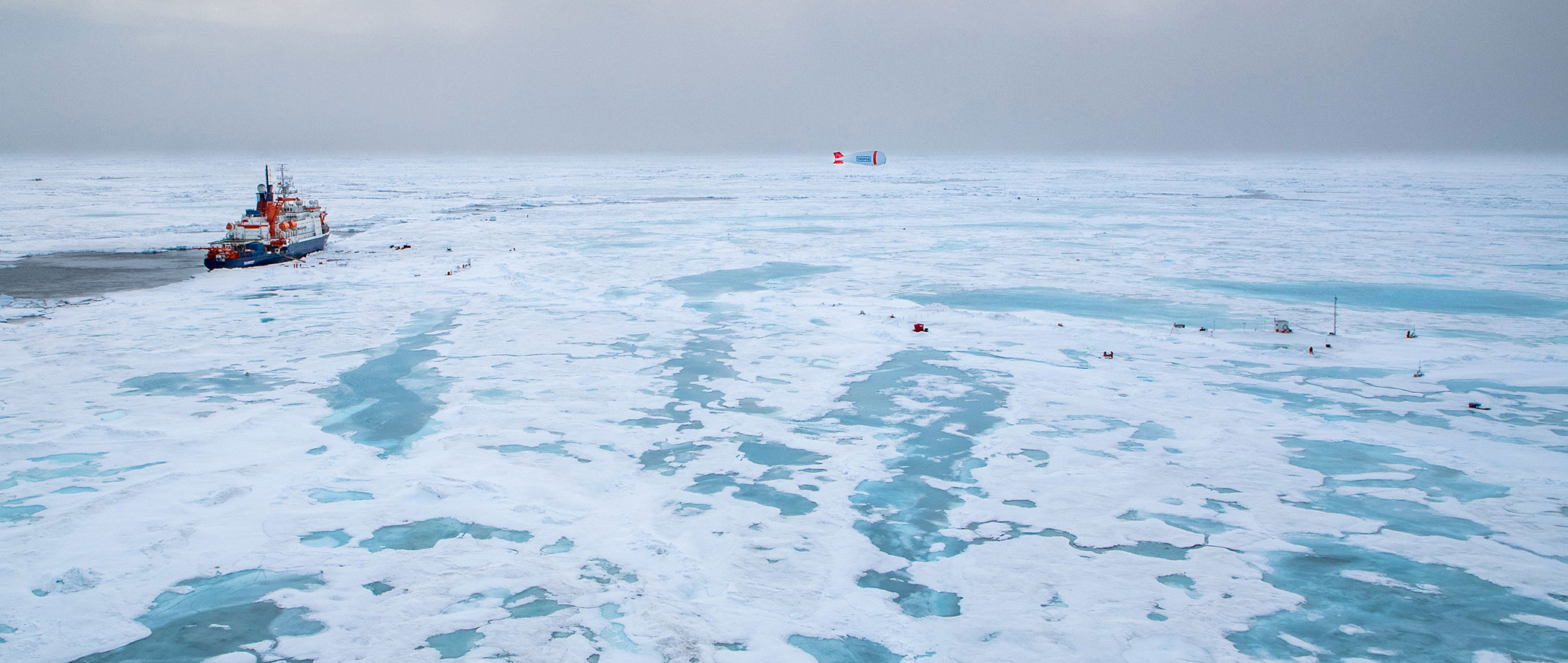
Polarstern served as a base for the field operations and a stable platform for intensive science (Figure 2). Its decks were crowded with state-of-the science equipment, some viewing the clouds overhead or sampling the passing air, while others peered down toward the surface emulating satellite observations of sea ice. Cranes often lowered a rosette or nets down into the adjacent water column. Laboratories hosted devices that probed physical samples of seawater and ice. Every six hours a weather balloon ascended from the helicopter deck. On the ice surrounding Polarstern, an extensive network of pathways and powerlines supported scientific installations and sampling. Stations with such monikers as Met City, Ocean City, and Balloon Town were hubs of activity, featuring collections of devices measuring the coupled system away from the adverse impacts of the vessel itself. Zones were identified for ice coring, snow transects, upper ocean profiling, operating underwater vehicles, and much more. Collectively, the components of this central observatory comprised a cross-disciplinary centerpiece of MOSAiC, providing a complex characterization of interwoven climate processes.
|
|
Spatial heterogeneity of surface types and other properties affects coupling at a variety of scales and must ultimately be represented in our models. To address this need for scaling, a distributed network was established that stretched for more than 40 km in all directions from the central observatory, in some ways embodying a drifting model grid cell (see Figure 1). Comprised of autonomous buoys and sampling devices, this network included a collection of supersites and moderate-sized sites with different combinations of sensors, and an array of nearly 100 position buoys to monitor ice movement and deformation. To place this drifting MOSAiC constellation into the pan-Arctic context, satellite and aircraft observations helped to bridge to larger scales. At the same time, MOSAiC was intentionally equipped with sensors that link to numerous Arctic observing networks with nodes in Svalbard, Alaska, Scandinavia, and elsewhere.
Like expeditions in the past, MOSAiC was beset by numerous challenges. Ice dynamics were active early and often, forcing numerous re-installations and adaptations of strategy. Frequent visits from polar bears kept scientists alert and cautious. Rapid drift of the ice during the year necessitated a late summer relocation of Polarstern. Perhaps the largest challenge, the global COVID-19 pandemic, threatened the expedition at its mid-point and forced dramatic shifts in operational plans. Despite these challenges, MOSAiC persisted.
The year in the Arctic ice was an interesting one scientifically. At least 20 storms were sampled, providing a view into major dynamical shifts in the atmosphere-ice-ocean system, warm air intrusions into the Arctic, and the processes involved in air- and water-mass evolution. An extensive freshwater layer capped the ocean in summer, affecting the vertical distribution of ocean communities and the exchange of gases. Unique platelet ice formations were observed, and internal ice stress was documented. The pan-Arctic circulation characterized by the Arctic Oscillation Index was at record highs in the winter, leading to a particularly strong polar vortex and substantial stratospheric ozone depletion. Importantly, the expedition was able to link processes that played out over a full annual cycle, bridging seasons and characterizing the rarely observed winter in great detail.
The MOSAiC expedition was an incredible success. Scientifically, it broke new ground by offering many observations that are the first of their kind. Programmatically, it embodied the spirit of international collaborative science, leveraging the support of 20 nations toward addressing shared scientific priorities. The expedition helped to build capacity in key ways by training a whole new generation of Arctic scientists and offering new insights into field research on thinning sea ice. Most importantly, MOSAiC has provided a huge legacy of data that will serve the research community for decades to come and provide the foundation for accelerated understanding and improvement of model predictive capabilities in the Arctic. As they are quality controlled and finalized, data are becoming available on the MOSAiC data archive at the German PANGAEA Data Publisher, the US Arctic Data Center, the US Department of Energy Atmospheric Radiation Measurement data archive, the UK Polar Data Centre, the British Oceanographic Data Center, and elsewhere. All data must be finalized and publicly available by the start of 2023. Further information on the MOSAiC expedition is available in overview papers published as part of the MOSAiC Special Feature in the journal Elementa (Nicolaus et al., 2022; Rabe et al., 2022; Shupe et al., 2022; and others to follow).


