Full Text
Introduction
In Hawai‘i, a $19 billion loss is anticipated due to the 3.2 feet (1 meter) of global sea level rise (SLR) predicted earlier this century to occur by 2100, while, in fact, 3 to 4 feet (.9 to 1.2 meters) of SLR by 2100 are now estimated as a mid-range scenario (HSCC, 2022). In Waikīkī, the economic hub of Hawai‘i’s tourism industry, future flooding caused by SLR, groundwater inundation, king tides, rainfall, and storm surge are projected to become a chronic disruption by mid-century (Habel et al., 2017, 2020). In contrast to retreat, one approach to managing SLR in dense urban areas, such as Waikīkī, is to consider an “in-place” flood adaptation or accommodation strategy. An interdisciplinary team of faculty and students at the University of Hawai‘i at Mānoa are merging science with design to create conceptual urban and architectural design renderings in order to visualize SLR adaptation strategies over time for buildings, utilities, transportation, and open space. Through iterative, structured public outreach, this research provides designers, planners, and policymakers with valuable insights into a diverse group of stakeholders’ preferences and their comments on each adaptation strategy. It supports the resilient planning goals outlined by the state, the City and County of Honolulu, and also the Waikīkī Special District Guidelines (DPP, 2021). In addition, through coursework and employment, students are learning how they might address SLR in their future careers.
Methods
In 2020 and 2021, students and the research team reviewed flood resilience guides, identified relevant adaptation strategies, and illustrated them as icons (Figure 1). The team hosted a series of five workshops with over 70 invited stakeholders to survey and discuss in small groups each strategy’s applicability to Waikīkī. In all presentations, stakeholders included neighborhood board members, Native Hawaiians, government employees, residents, architects, planners, landowners, realtors, business owners and managers, tourism and recreation industry employees, teachers, students, and visitors. After the workshop, feedback was recorded in a report that guided future renderings and fostered community education and engagement.
|
|
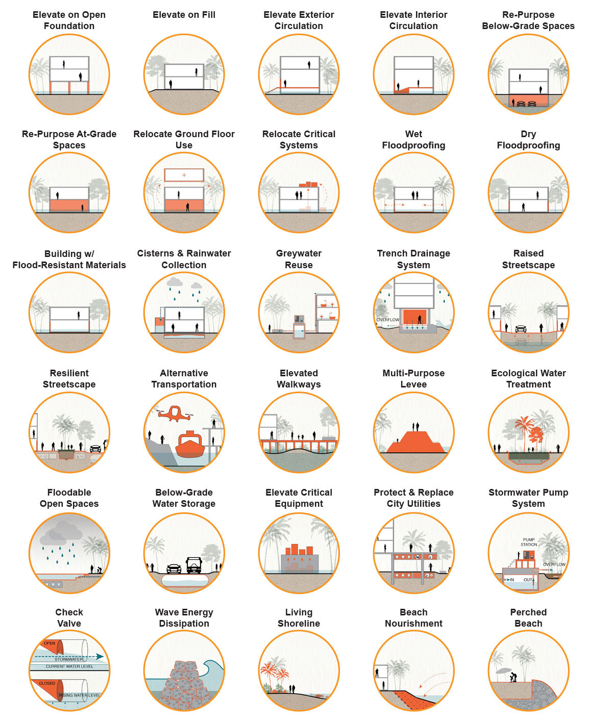
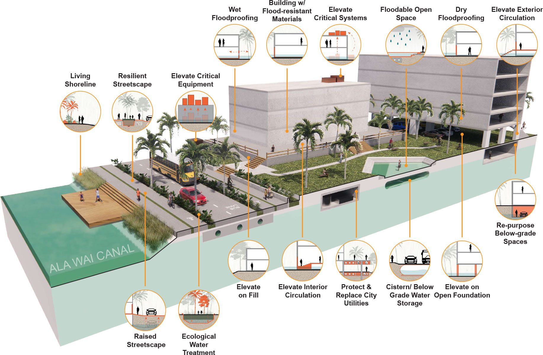
In 2022, the team created and presented initial architectural renderings in which the icons call out adaptation strategies. Applicable adaptation strategies for buildings, open space, transportation, and utilities in 2050 and 2100 were integrated into two study sites as well as a generic site (Figure 2) in order to succinctly illustrate all strategies. The team also developed a method for estimating future SLR-adjusted Design Flood Elevations for 2050 and 2100 depicted through drawings that include current and future water levels (sea level rise, king tides, and 1% annual chance flood). The design criteria and drawings were found to help stakeholders understand increasing flood risk to the built environment and develop tailored guidance. During 2022, the team introduced the architectural renderings and design flood elevations in public presentations, surveyed 120 stakeholders on the relevance of each adaptation strategy in the renderings, and iteratively applied the results to a third study site.
|
|
In 2023, the team advanced the site-specific adaptations by identifying additional strategies; collaboratively developing additional icons, renderings, and drawings; conducting public presentations; and recording surveyed feedback from 220 stakeholders. The public project website includes renderings, a summary booklet, public feedback reports, and presentation slides and videos (https://seagrant.soest.hawaii.edu/meguro-adapting-waikiki/).
Results
In response to the 2021 presentations of diagrammatic flood adaptation strategy icons (Figure 1) and photos, the majority of stakeholders rated all strategies as applicable while acknowledging concerns. The most applicable strategy was elevating critical equipment in interior and exterior spaces. Most stakeholders thought government policies should address sea level rise.
The team found that the renderings (similar to Figure 2) provided a key tool for making the flooding and adaptation strategies tangible and enabling public survey and comments. Additionally, the renderings were used to visually represent and apply the design criteria developed in site-specific elevation drawings. Unprompted stakeholder discussion addressed the desirability, feasibility, policy, public buy-in, cost, and sequencing of strategies ranging from elevating roads, sidewalks, and buildings to implementing on-site stormwater retention.
In response to renderings created in 2023, stakeholder surveys show the most applicable strategies for 2050 include: relocate critical systems, living shorelines, ecological filtration of stormwater, and floodable open space. Stakeholder questions such as “How do we set finished (first occupied) floor elevations in revised building codes to meet architects’ standard of care, given that buildings have long service life?” reinforce the need for a methodology to determine future building design flood elevations that account for sea level rise.
Discussion and Conclusion
This project demonstrates the potential for academia’s role in addressing public issues (ACSA, 2019) such as climate change with notable project engagement of over 700 people in professional, business, governmental, and academic settings. Stakeholder comments highlighted the need for district-scale planning and building-scale guidelines informed by future flooding predictions. This academic research project’s methods and products can inform future local policy development.