Full Text
What Are DTOs and How Can They Build Capacity?
An emerging technology for building capacity to make decisions in the ocean space is the development of Digital Twins of the Ocean (DTOs). A DTO is a virtual replication of the ocean environment, including its properties, behaviors, and processes (https://www.mercator-ocean.eu/en/digital-twin-ocean/). These digital replicas are created using a combination of real-time data collected from satellites and thousands of sensors deployed around the world, as well as outputs of advanced models and computer simulations.
By consolidating and integrating a wide range of environmental and human-use data resources into a single interactive platform, DTOs help transform these data into knowledge products that can be used by a variety of stakeholders. They offer ocean and coastal managers the ability to create models and simulations to assess the impacts of human activities, management decisions, and user interactions. For decision-makers, DTOs can help explore “what if” scenarios (e.g., the effects or implications of policy decisions) in a realistic, digital environment that mimics the real world in real time, enabling implementation of adaptive management strategies to help account for uncertainties such as climate change.
DTOs also promote a two-way flow of communication between policymakers and data producers, continuously generating information and knowledge that is essential to the development of sustainable and dynamic ocean policy. However, DTOs should also be considered open access tools for nongovernmental stakeholders, including educators, students, scientists, resource users, businesses, and individuals trying to solve real-world problems that impact their daily lives.
Developing Capacity in the Wider Caribbean Region
To demonstrate the potential of DTOs for regional marine spatial planning (MSP) and to identify additional use cases for the wider Caribbean region, the United Nations Environment Programme (UNEP) Global Environmental Monitoring System for the Ocean and Coasts (GEMS-Ocean) Programme convened a data “hackathon” (a collaborative workshop-style event where people come together in person or virtually to solve a problem) as part of a larger Caribbean Sea Digital Twin Prototype (CSDTp) initiative. The hackathon was organized with support from UNEP’s Cartagena Convention/Secretariat/Caribbean Environment Programme (CEP) and the Intergovernmental Oceanographic Commission of United Nations Educational, Scientific and Cultural Organization (IOC/UNESCO) and facilitated by the Breda University of Applied Sciences. The Netherlands Ministry of Infrastructure and Water Management (IWM) provided financial support.
The two-and-a-half-day hackathon was held October 3–5, 2023, in Oranjestad, Aruba, and brought together approximately 20 participants with varying backgrounds and expertise within the CARICOM (Caribbean Community) region, which includes the Americas, the Caribbean, and the Atlantic Ocean. Participants included data experts, fisheries scientists, hydrologists, marine spatial planners, policymakers, and other stakeholders.
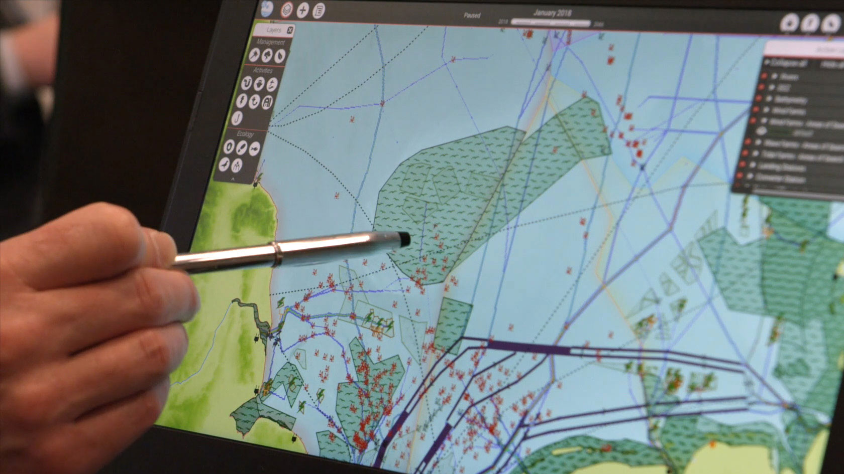
Participants engaged in a series of critical thinking exercises using two serious games (applied games designed for learning or practicing a skill): the MSP Challenge Board Game and the MSP Challenge Simulation Platform (https://www.mspchallenge.info/). The Board Game had participants adopt the roles of various stakeholders in the MSP process and challenged them to jointly develop a marine spatial plan while addressing conflicting ecosystem, geopolitical, and sectoral interests. Afterward, participants were divided into small groups and introduced to the Simulation Platform, which allowed them to interact with real-world data layers in a DTO for the North Sea (Figure 1).
|
|
Throughout the hackathon, there were also participant-led presentations on MSP activities in Aruba, Barbados, Bermuda, Cuba, Saint Kitts and Nevis, and Trinidad and Tobago. Collectively, these activities promoted discussion about how DTOs could be used within the wider Caribbean community, not just for marine spatial planning purposes, but to support other regional initiatives and programs, including ecological monitoring and forecasting, coastal land-use planning and management, habitat conservation and restoration, blue economy development, policy assessment (“what if” scenarios), and education.
The outcomes of the hackathon, including recommendations for next steps in the development of an initial design for a DTO of the wider Caribbean Sea, were presented at the High-Level Meeting of Responsible Ministers at the 2023 Conference of Parties for the Cartagena Convention on October 6, 2023.
Hackathon Findings
As one of the collaborative learning exercises, participants were asked to consider what features a DTO would require in order to be a practical tool for multiple stakeholders across the Caribbean region. Suggestions included:
- An increase in the availability of fit-for-purpose data (e.g., correct scale, relevant attributes, and temporal extent) and high-quality layers of environmental and human-use data.
- The ability to show marine spatial planning activities in near-to-real time at both national and regional levels.
- A centralized regional data repository that provides rapid, easy access to distributed datasets, including oceanographic, coastal ecosystem, and human-use data.
- An inventory of existing data and data platforms, including the identification of local and regional data gaps.
- A standardized approach to data collection, management, and reporting.
- A common language public interface that can easily be used and understood by non-scientific audiences. Working with science communicators is one possible way to accomplish this.
In addition, participants recommended that the creation of any long-term DTO initiative should involve early career ocean professionals (ECOPs), defined as individuals who self-identify as having 10 years or fewer of professional experience in any field related to the ocean (https://www.ecopdecade.org/learn-ocean-decade/). ECOPs will be actively using DTOs later in their careers, so involving them in DTO development through workshops and trainings creates a pipeline of individuals familiar with the platforms and data, thereby building capacity in the region.
During this exercise, participants acknowledged that achieving these objectives might be stalled or obstructed by geopolitical issues and gaps in capacity, such as:
- The lack of long-term funding to support data collection and analysis efforts, as well as to sustain the training of individuals to use the platform.
- The lack of bilateral/regional data-sharing agreements, including potential alignment of national data-sharing legislation, policies, and strategies across the region.
- The need for a high-level, multilateral organizations, such as UNEP and IOC/UNESCO, to build and maintain confidence among governments and private industry that data will only be used to develop management and decision-making tools.
At the close of the hackathon, participants identified next steps for building capacity required to develop a regional DTO for the wider Caribbean Sea.
- Create a community of practice to guide and advise the process.
- Anchor efforts within regional activities, such as the Wider Caribbean Ocean Coordination Mechanism, to provide a larger platform for support, virtual training opportunities, and knowledge transfer.
- Identify regional champions to advocate for the project.
- Develop and implement a “train the trainers” program for the MSP Challenge serious games or similar learning tools.
- Create synergies with existing programs in the region by demonstrating to high-level officials how a short-term investment of time and money can produce long-term results for the good of their nations and the health and well-being of the regional ocean.
Lessons Learned
Following the conclusion of the hackathon, participants were asked to complete a survey about their experiences, including what aspects they found most useful and what areas they felt could be improved upon. After collating the results, the following were identified as areas of improvement for future hackathons:
- Provide participants with access to the MSP Challenge Simulation Platform beforehand so they have a better understanding of how to interact with the digital data layers, as well as specific features required by each individual’s computing device. This will allow attendees to participate more fully during the hackathon.
- Allow time for more interactive activities with the MSP Board Game so that participants leave with a greater feeling of ownership over their work and its outcomes.
- If future hackathons are planned, organizers should make every attempt to have the data used in the MSP Challenge Simulation Platform align with the region in which the hackathon is held.
- Allot more time for networking to foster future collaborations and hold the hackathon closer to the city center to provide greater accessibility to post-hackathon activities and sites.


