What is a GEOTRACES Style Program?
The best way to explain a GEOTRACES style program is to describe how the idea for GEOTRACES came about as this century began. During chats among a few marine geochemists at different meetings, but mostly at the 15th Joint Global Ocean Flux Study (JGOFS) Scientific Steering Committee meeting held in Bergen, Norway, in April 2000, a consensus emerged regarding an urgent need to couple multiple tracers that had been developed separately since the early 1980s in order to better constrain the sources and fates of dissolved and particulate trace elements and isotopes, and of water mass circulation. On the one hand, radionuclides—more specifically Ra, Th, and Pa—can act as chronometers. On the other hand, reactive elements such as the rare earth elements and Nd or Pb isotopes may act as source and dissolved-particle exchange tracers. Tackling biogeochemical processes in seawater is so complex that multiple proxies must be used in tandem to properly quantify key mechanisms. Gatherings of the marine biogeochemistry community at an American Geophysical Union conference town hall in fall 2002 and then in Toulouse in spring 2003 rapidly broadened the ambition to include tackling the big modern chemical oceanographic questions. For example, understanding the dynamics of the biological pump would require researchers who work on bioactive trace metals (BTM) to collaborate with experts on geochemical tracers, while also maintaining a solid description of physical oceanography and involving modelers. Thus, GEOTRACES was born.
The Benefits of Coupling Multiple Geochemical Tracers
Let's focus on work undertaken in the changing Arctic Ocean to illustrate the advantage of coupling physics, geochemical tracers, and bioactive elements. In 2015, two GEOTRACES expeditions together provided a full trans-Arctic section across the Arctic Ocean, one on USCGC Healy (GN01), the other on the German R/V Polarstern (GN04). (See Jensen and Colombo, in this issue, for a look at Fe and Mn in this region from these cruises.) In surface waters, the section crossed the Transpolar Drift, identified by the high fraction of water derived from Siberian rivers (Kipp et al., 2018; Rutgers van der Loeff et al., 2018). 228Ra data in surface waters measured during both cruises showed that 228Ra in the Transpolar Drift has nearly doubled since earlier sections in 2011 and 2007 (Figure 1). This rapid 228Ra increase was attributed to stronger wave action on shelves resulting from a longer ice-free season, in other words due to climate change. Associating 228Th, 129I, SF6, 234Th, and 210Po to the 228Ra results allowed researchers to disentangle the vertical (mostly biogenic) from the advected fluxes of carbon and biogenic trace metals (Kipp et al., 2018; Rutgers van der Loeff et al., 2018) and to estimate a ventilation time of 20 years for the intermediate waters and 480 years for waters from the deep Makarov-Canada Basin.
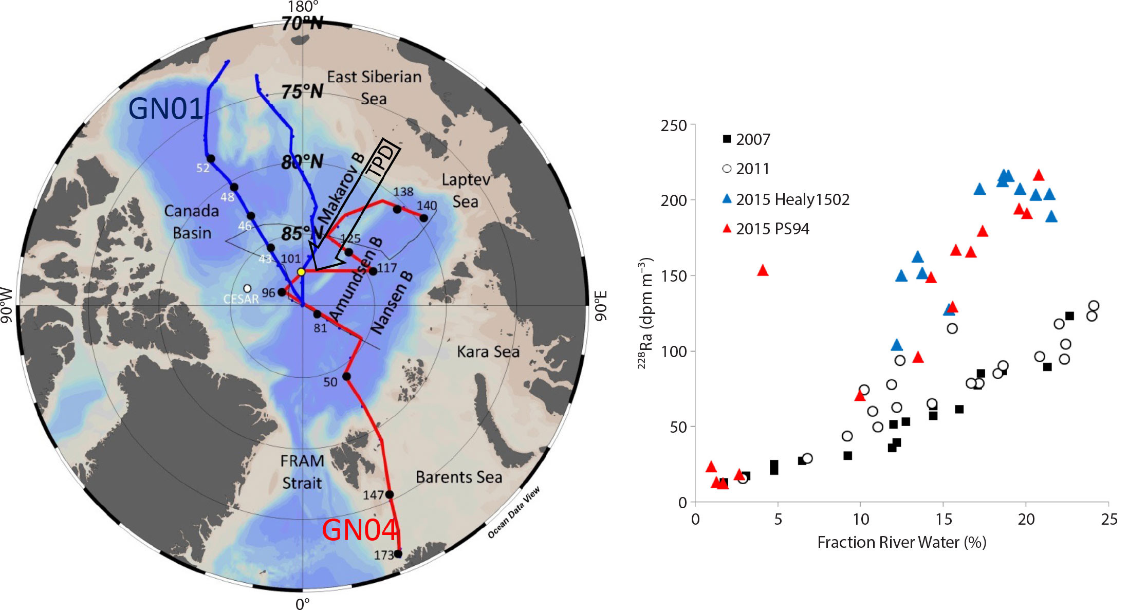
FIGURE 1. Arctic GEOTRACES cruises and Ra in the Transpolar Drift. (a) GEOTRACES cruise tracks (2015) conducted with USCGC Healy (US GN01 (Healy1502), blue) and R/V Polarstern (German, GN04 (PS94), red). (b) 228Ra data measured in surface waters are reported for earlier sections in 2011 (black circles, track in black) and 2007 (GIPY11, black squares, track not shown) and for the Healy (blue) and Polarstern (red) sections. These data clearly illustrate that 228Ra in the Transpolar Drift has about doubled in roughly four years. Modified from Ritgers van de Loeff et al. (2018) and Kipp et al. (2018). > High res figure
|
Bioactive trace metal data acquired on GN01 were also used to estimate the mean residence time of Fe, Mn, Ni, Cd, Zn, and Cu in Arctic surface waters with respect to atmospheric deposition (Kadko et al., 2018). These calculations utilized mixed layer trace element inventories, aerosol solubility determinations, and estimates of the atmospheric trace element flux into the upper ocean. The latter was estimated by the product of the 7Be flux (determined by the ocean 7Be inventory) and the element/7Be ratio of aerosols (Kadko et al., 2018; Charette et al., 2020). Surprising long surface dissolved BTM residence times were found (e.g., 20–40 years for Fe, roughly 10 times more than in the remaining open ocean), likely due to the fact that BTM are strongly bound with abundant organic matter from Siberian rivers, preventing them from efficient scavenging to particles. Thus, dissolved nutrient-type BTM can be transported over 1,000 km from their source and act as surface water fertilizers up to the central Arctic (Charette et al., 2018).
The breadth of parameters afforded by multiple cruises, countries, and investigators of the international GEOTRACES program allowed these data to be assembled and interpreted, and key geochemical processes to be calculated.
Fieldwork Implications for Using Multiple Geochemical Tracers
As a consequence of the program’s scientific strategy, GEOTRACES style oceanographic cruises gather many different disciplines on the same ship, with each research team having its own requirements. Physical oceanographers manage the temperature, salinity, oxygen, and current probes (lowered acoustic Doppler current profilers, shipboard [hull-mounted] acoustic Doppler current profilers), in general working in shifts of at least six people. Biogeochemical parameters require collecting water and particles from the surface to the deepest abysses. Water is collected using a sampling system (CTD rosette) that contains sophisticated water collecting bottles as well as sensors that continuously record water salinity (C), temperature (T), and depth (D) (Figure 2a). Particles are either collected by filtration of the water collected in these bottles or by using large volume filtration pumps deployed at different depths (in situ pumps). Ancillary parameters (carbonate chemistry, oxygen, nutrients) as well as geochemical tracers that are not prone to contamination are collected with a standard CTD rosette. BTM and their ligands are collected with a clean sampling system (i.e., a CTD equipped with bottles coated with Teflon and are free of metal parts), or a custom-built system (Cutter and Bruland, 2012).
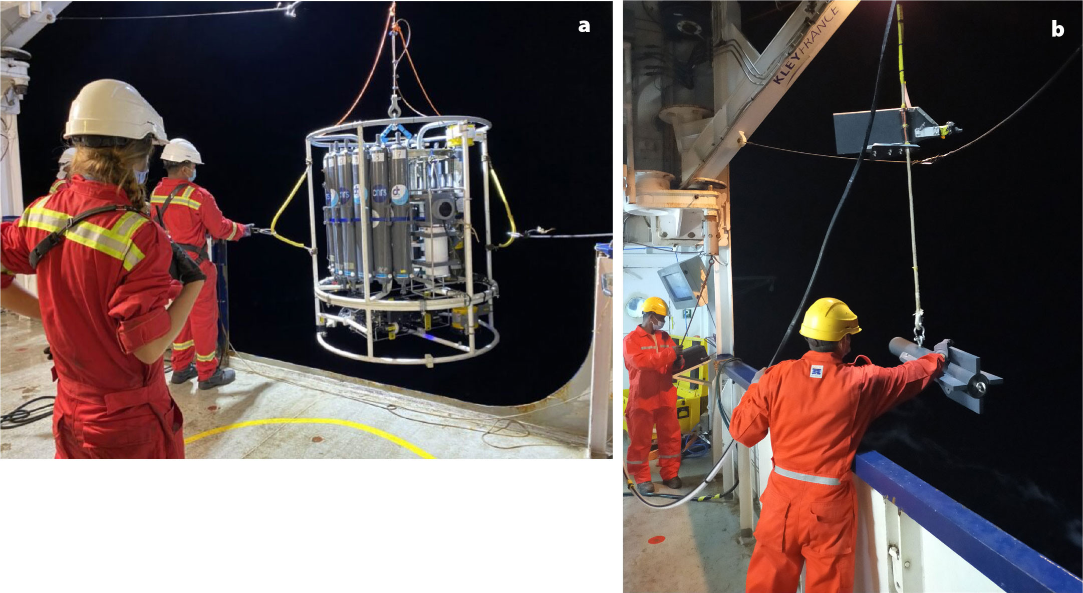
FIGURE 2. (a) The standard CTD rosette employed in the framework of the GEOTRACES GS02 SWINGS cruise comes back aboard. (b) The “fish” is launched off the side of R/V Marion-Dufresne as part of the GEOTRACES GS02 SWINGS cruise. Photo credit: Emmanuel de Saint Léger. > High res figure
|
For elements present at very low concentrations in seawater (e.g., radium cited above), large volumes of water are needed to collect sufficient quantities of the element for analysis; here, the targeted trace element is collected onto cartridges mounted on the in situ pumps by passing large volumes of seawater through them (Bishop et al., 2012). Atmospheric dust samples are collected through filters in instruments mounted on the upper bridge (Morton et al., 2013; see Buck et al., 2024, in this issue). Small sediment corers can be deployed on the end of one of the sampling wires (standard rosette or in situ pumps) in order to study bottom processes (Homoky et al., 2013). A clean sampling “fish” can also be deployed behind the ship while sailing, providing samples for BTM distribution at the surface along the section tracks (Cutter and Bruland, 2012; Figure 2b). Phytoplankton sampling nets can also be deployed, because they give access to the first step of the trophic chain, with phytoplankton community composition and dynamics influenced by the abundance of different BTM. If ice or snow sampling is required, appropriate tools must be on board. All sensors allowing the measurement of meteorological conditions must be deployed. Once the samples are on board, each team goes to work in its own small laboratory.
Different countries might manage these steps differently. For example, the United States uses supertechs to do all the filtering (see Halbeisen, 2024, in this issue). During the French GEOTRACES SWINGS cruise (GS02), 48 participants were distributed in 15 different laboratories on R/V Marion Dufresne for two months (Figure 3). In general, GEOTRACES cruises are long, up to two months each (Jeandel and Planquette, 2021; Halbeisen, 2024, in this issue).
In other words, a GEOTRACES style sampling cruise looks like an anthill: active day and night, with everyone focusing on the most precious thing on board—seawater and the particles it contains.
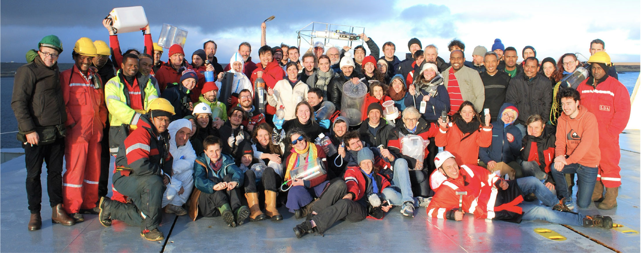
FIGURE 3. Scientists and crew on the French GEOTRACES SWINGS cruise (GS02) on R/V Marion-Dufresne. Photo credit: Sibylle d'Orgeval. > High res figure
|
Multidisciplinary Science on Large Ships: What About the Carbon Footprint?
Today, most countries are seeking to reduce their carbon footprints. This includes research involving large-scale equipment such as big oceanographic research ships. To illustrate, the French oceanographic fleet emits 30,000 tons eqCO2 per year. GEOTRACES style cruises are thus hitting a paradox: while cruises are required to estimate the role of the ocean as CO2 sink, the size of the ship leads to a large amount of carbon emissions.
All through 2023, working groups discussed how the French oceanographic research communities could reduce their footprints. In addition to thoughts about the planning and organization of the deployment of the French fleet, the added values of the following methods were discussed: uncrewed surface vehicles (USVs), uncrewed hybrid vehicles (UHVs), autonomous underwater vehicles (AUV/gliders), amphibious drones, atmospheric drones, drifting instrumentation (profilers, buoys, vertical velocity profilers), and also what could be done using sailboats and the potential contribution of telepresence.
These preliminary deliberations led to a seminar in Brest, France, during January 29–31, 2024. More than 200 attendees discussed approaches that could be used to reach the 40% carbon reduction targets for 2030 recommended by the International Maritime Organization (IMO). Participants agreed that some actions could be implemented in the near future to reduce the footprint using the current state of technology. From the most efficient to the least, they included: using new technologies for propulsion (mostly biofuels, but also sails, kites, etc.), reducing the volume of transit by prepositioning the ships in the different oceanic basins and by reducing transit velocity, using various drones/floats for complementary operations, and improving hydrodynamics and materials during ship construction. All these proposals are still debated within the community and also more broadly; only a concerted international effort will ensure the success of this ambitious objective.
None of the solutions to reducing our carbon footprint explored at the symposium called into question the importance of large-scale oceanographic vessels for conducting multidisciplinary campaigns, which is deemed critical for continuing the GEOTRACES program (see Anderson, 2024, in this issue).
Acknowledgments
The international GEOTRACES program is possible in part thanks to the support from the US National Science Foundation (Grant OCE-2140395) to the Scientific Committee on Oceanic Research (SCOR).