A Brief History
The international GEOTRACES program was developed to improve understanding of the distribution of trace elements and their isotopes (TEIs) in the ocean and of their sources, sinks, and internal cycling (see Anderson, 2024, in this issue, for a reflection on and overview of the GEOTRACES program as of 2023). To achieve these goals, a global effort to generate comparable data from basin-wide sections of TEIs was needed. Comparability is crucial, because the testing of hypotheses in an empirical science like chemical oceanography depends on the ability to prove that groups of data differ (or not) at a given statistical certainty level. Therefore, measuring data precisely and accurately translates directly to the ability to recognize trends, identify processes, and resolve the extent of features such as those from hydrothermal plumes and nepheloid layers.
As TEI analysis was known to be plagued by contamination and methodological artifacts, from the start of the program, GEOTRACES made intercalibration the cornerstone for achieving comparable results throughout the global ocean. Intercalibration ensures open sharing of methods and results among laboratories to achieve the most accurate data possible by reducing random and systematic errors that can occur at each stage of the process (sample collection, preservation, and analysis; Cutter, 2013).
Previous international efforts for intercalibration of trace elements began in 2001–2002 with iron, which was recognized to limit phytoplankton growth (e.g., Martin, 1990). This exercise involved a blind comparison of dissolved Fe (dFe) measurements by 24 laboratories from nine nations on a sample collected in the Atlantic Ocean (Bowie et al., 2006); it resulted in a large range of concentrations (0.2–1.2 nM dFe) and the recognition that attention to sample preservation was essential. This led to the US National Science Foundation (NSF)-funded Sampling and Analyses of Fe (SAFe) project in the Pacific Ocean with 32 scientists from 18 laboratories and eight nations participating in a field effort to determine dFe using different onboard methodologies and to compare them to shore-based analyses (Johnson et al., 2007). The goal was to produce consensus values (NRC, 2002) for a deep sample (1,000 m) and a surface sample that could be made available to the community as reference materials at no cost. Onboard scientists worked together to compare different methods of sample collection and preservation and shared best practices to reduce differences obtained from analysis (Johnson et al., 2007). On land, various international laboratories provided results from their analyses of dFe as well as other dissolved trace elements in order to generate consensus values (https://www.geotraces.org/standards-and-reference-materials/). Open collaboration within the trace metal community made the SAFe project a major success. The materials produced (approximately 600 surface and 600 deep samples) had consensus values for dAl, dCd, dCo, dCu, dFe, dMn, dNi, dPb, and dZn that were used to assess the accuracy of newly developed methods and of methods used in newly established laboratories. These consensus samples were essential for the launch of the GEOTRACES intercalibration efforts.
GEOTRACES Intercalibration Cruises and Outcomes
From the outset, GEOTRACES recognized that prior to section cruises across ocean basins, intercalibration efforts and consensus materials would be needed, and that they must include a full range of TEIs dissolved in seawater as well as from suspended particles and from aerosols. To this end, aerosols were collected in Miami, Florida, and two intercalibration cruises were undertaken: one in 2008 in the Atlantic Ocean, visiting the Bermuda-Atlantic Time-series Study [BATS] station, and one in 2009 in the Pacific Ocean that visited the SAFe station and a coastal station. The consensus materials generated during these cruises enabled establishment of intercalibration protocols, and the international community relied on these materials (along with SAFe samples) until they ran out (there is now an urgent need to generate new consensus materials). Intercalibration cruises were followed by workshops to openly discuss results, what worked and what did not work, and develop a list of agreed-upon best practices. These workshops led the different TEI communities to work on detailed protocols, from sampling to analyses, and they compiled the information into a “cookbook.” The first edition, made available in 2012, provided detailed granular information, such as TEI-specific equipment cleaning, sampling, preservation and processing procedures—in more detail than in any peer-reviewed publication. This cookbook included photographs and diagrams and information about materials and supplies in order to facilitate the successful undertaking of any TEI study by new analysts. In addition, elemental coordinators (experts in specific parameters) were identified in order to provide advice. Finally, an excellent compilation of papers on lessons learned was published in a virtual issue of Limnology & Oceanography Methods in 2018.
As methods for collection, preservation, and processing of TEIs are updated or new ones are recommended (Cutter and Bruland, 2012), they are shared internationally through updated versions of the cookbook (https://geotracesold.sedoo.fr/images/Cookbook.pdf). The release of version 4 is expected in spring of 2024.
GEOTRACES section cruises are designed to include a crossover station or stations whereby all aspects of sample collection, preservation, and processing can be compared and intercalibrated (e.g., different ships, rosettes for water collection, pumps for particles, and different analytical methods). At a minimum, three common depths are sampled during the two cruises occupying a crossover station, and/or samples are shared so that a good comparison can be demonstrated between analytical efforts before data are considered intercalibrated (Figure 1a). In practice, however, full depth profiles are usually sampled and compared. The analysts for the TEI being intercalibrated share their figures of merit (which include blank, detection limits, reproducibility, and external precision through the assessment of certified reference materials [CRMs] or consensus material) and details of their analytical methodology. As they compare their data, they report any differences observed. Data originating from the surface, or any other dynamic region, are not expected to be comparable. The reports are submitted using the GEOTRACES Data for Oceanic Research (DoOR) portal (https://geotraces-portal.sedoo.fr/pi/). The report is then reviewed by the Standards and Intercalibration Committee.
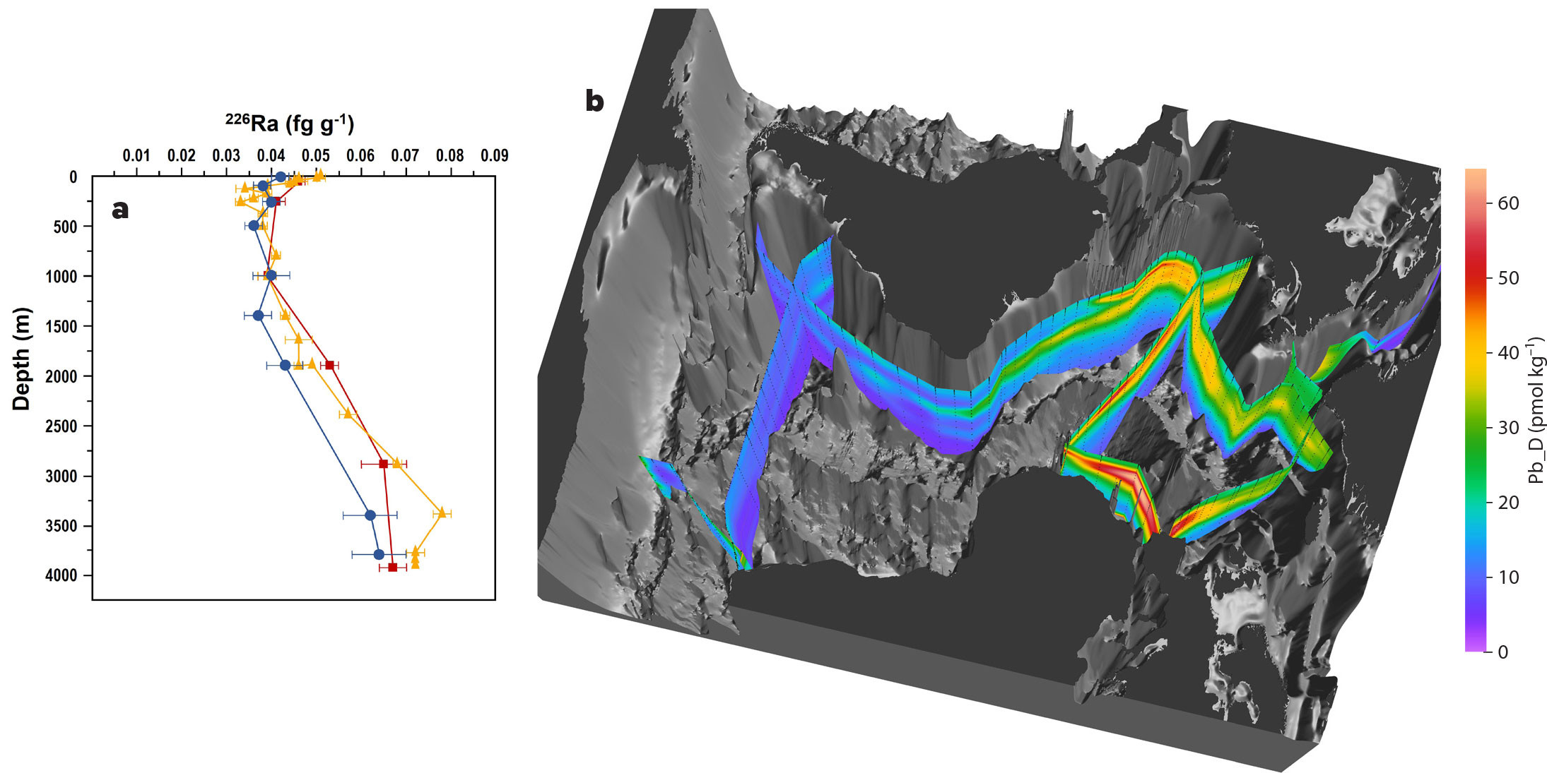
FIGURE 1. (a) Intercalibrated profiles at the Arctic crossover station for 226Ra activities (disintegrations per minute per 100 liters) from GEOTRACES GN04 (R/V Polarstern expedition PS94, station 101) and GEOTRACES GN01 (USCGC Healy expedition HLY1502 station 30). This is an example of a multinational exercise where three different methods of sampling, storing, and analyzing (Rutgers van der Loeff et al., 2018; Kipp et al., 2019; Vieira et al., 2021) were compared. Figure modified after Vieira et al. (2021) (b) Example of intercalibrated dissolved lead data from the Atlantic Ocean. Image courtesy of Reiner Schlitzer, Alfred Wegener Institute. > High res figure
|
The International S&I Committee
As cooperation is essential for intercalibration, an International GEOTRACES Standards and Intercalibration (S&I) Committee was created to shepherd and encourage the intercalibration effort. This committee is composed of international colleagues with expertise on the various TEIs who engage positively with the community to facilitate broad participation and to support the intercalibration process through diplomacy and consistency. This has positioned the committee as an essential entity in the GEOTRACES effort. A rotating membership ensures balance in geographical location, career stage, and gender (see https://www.geotraces.org/the-geotraces-standards-and-intercalibration-committee/ for past and current committee membership). The bulk of the committee’s work is in reviewing and approving the intercalibration reports submitted by scientists who wish to include their data as part of an Intermediate Data Product (IDP) release (for more details on the IDP process, see Schlitzer and Mieruch-Schnülle, 2024, in this issue). As the number of parameters submitted for inclusion into GEOTRACES IDP releases has grown, review and approval of intercalibration reports has evolved into a more streamlined and automated process, thanks to the DOoR Portal.
After submission to DOoR, the intercalibration report is assigned to one (or more) experts on the S&I Committee, who then review the report and liaise with the authors when more information is required. The S&I member presents the report to the rest of the committee, whose members collectively decide whether the report is approved and the dataset ready for inclusion in the next IDP, or if this report needs additional information or clarification prior to approval (Figure 2). The S&I committee chairs use the DOoR portal to indicate the status of reports and datasets. Once a dataset is intercalibrated, inclusion in the next IDP is guaranteed, pending scientist permission to release their data. This work results in IDP releases with internally consistent datasets (Figure 1b).
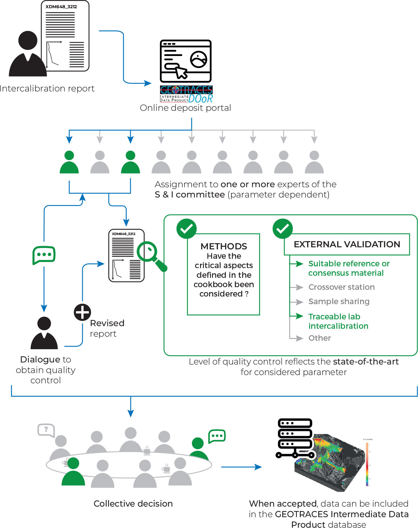
FIGURE 2. This intercalibration process diagram shows the different steps, from initial intercalibration report submission to data release, that lead to a GEOTRACES Intermediate Data Product. > High res figure
|
Legacy
Although collaboration is expected in order to make significant advances in science, “coopetitive” (a combination of cooperative and competitive behavior) attitudes often occur (e.g., Hernaus et al., 2019), slowing down progress. The GEOTRACES program sought to avoid this pitfall during its intercalibration efforts by designing activities that enabled participants to work in a truly cooperative mode. In addition, summer schools and student exchanges allow students to learn new methods and become entrained within the GEOTRACES community (see Halbeisen, 2024, in this issue). By breaking down barriers, GEOTRACES has been able to build capacity globally in order to accomplish its mission. Furthermore, intercalibration exercises and/or sample exchanges encourage collaboration among scientists who have not worked together before with the goal of including more intercalibrated datasets into IDPs. Over the past decade, intercalibration activities have enabled strong community building among various generations of scientists from around the globe. In particular, early career scientists, now trained under this cooperative intercalibration umbrella, will continue to share advances in their protocols, strengthening capacity building and GEOTRACES outcomes. Finally, what seemed to be a potentially insurmountable process at the beginning has become commonplace and has allowed for an unprecedented oceanic atlas of TEIs that presents state-of-the-art, high-quality data. The process of intercalibration has proven to be not only a validation step but also a driving force for ever improving analytical capabilities that yields new processes and trends. The resulting data product also serves as a constantly growing reference for the modeling community, which can now extract the internally consistent GEOTRACES-produced data to enhance understanding of oceanographic processes.
We hope the GEOTRACES intercalibration process can serve as a model for other international efforts seeking high quality data.
Acknowledgments
The authors thank R. Sherrell and K. Bruland, who along with G. Cutter, made the 2008–2009 intercalibration cruises possible. We also thank all past and present S&I committee members: Roger François, Lou Codispoti, Ed Boyle, Shaojun Zhong, Pere Masqué, Catherine Jeandel, Peter Croot, Hajime Obata, Michiel Rutgers van der Loeff, Per Andersson, Tina van der Flierdt, Peter Sedwick, Alyson Santoro, Lars-Eric Heimbürger-Boavida, Karen Casciotti, Yoshiko Kondo, Luke Bridgestock, Tim Conway, Christopher Hayes, Julie Granger, and Yeala Shaked. The DOoR portal greatly improved our way of working, and we thank its developers, François André and Elena Masferrer-Dodas. The international GEOTRACES program is possible in part thanks to the support from the US National Science Foundation (Grant OCE-2140395) to the Scientific Committee on Oceanic Research (SCOR).