Full Text
Introduction
The Backyard Buoys project (https://backyardbuoys.org/) enables Indigenous and coastal communities to gather and use wave data to enhance their blue economies and hazard protections. These communities have been historically underserved, and climate change is making weather and wave predictability even harder. Leveraging low-cost, scalable marine technology in partnership with regional ocean observing networks, Backyard Buoys offers a system for community-managed ocean buoys and data access to complement Indigenous Knowledge. These innovations include a sustainable process for community-led implementation and stewardship of affordable ocean buoys along with co-designed and co-produced mobile and web-based applications (apps) that render data easy to access and understand.
Democratization of Data
Backyard Buoys was funded by the US National Science Foundation (NSF) Convergence Accelerator program in 2021 in the Blue Economy track. Our project brought together three regional ocean observing networks of the US Integrated Ocean Observing System (IOOS), underserved Indigenous communities in those regions, and a sensor company (Sofar Ocean) with a lower-cost commercially available wave buoy that measures significant wave height, period, and direction along with directional wave spreading, sea surface temperature, and barometric pressure. We worked collectively to democratize local wave measurements and provide a solution to the hurdles presented by observing technologies that are too expensive and cumbersome to purchase and sustain. Through co-design of an implementation and stewardship plan, as well as apps tailored to transmit data in low-bandwidth scenarios, we are revolutionizing wave observations. By using lower-cost tools and deepening human and data connections, our collective system addresses needs within the hyper-local scale—something sorely lacking in the design of existing ocean observing systems—while assuring it operates within a globally connected network.
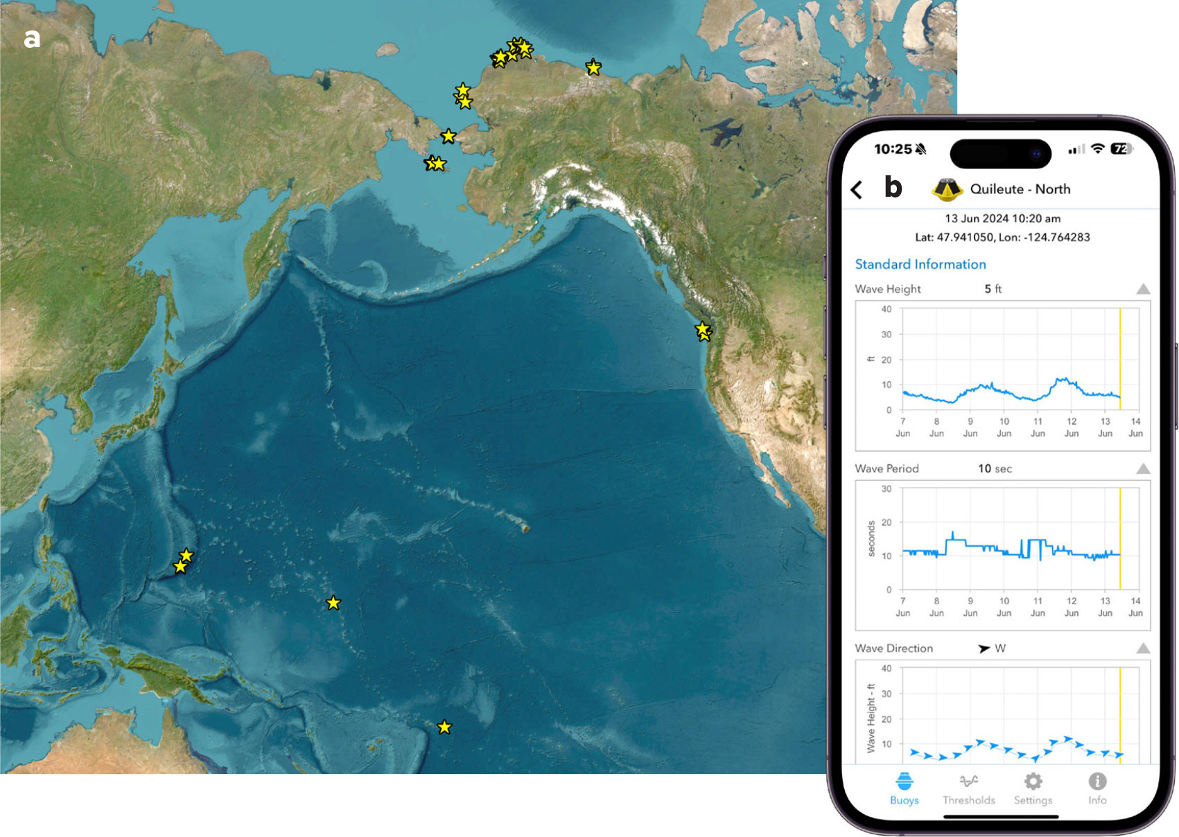
Backyard Buoys is being implemented in Alaska, the Pacific Islands, and the Pacific Northwest (Figures 1 and 2a). Each region is home to Indigenous communities who have lived off the sea and that are protected by natural wave barriers—sea ice, coral, and kelp beds, respectively—each of which is affected by climate change. While each location is unique, similarities have united the team effort. The three IOOS regional ocean observing systems, respectively named the Alaska Ocean Observing System (AOOS), the Pacific Islands Ocean Observing System (PacIOOS), and the Northwest Association of Networked Ocean Observing Systems (NANOOS), have existed for ~20 years, engaging with and building trust with communities in their regions to serve coastal ocean data, forecasts, and information products that meet their needs. However, wave data from remote areas were not served due to the cost of national and academic strategies that were not designed to address local nearshore environments. Each region has a specific motivation that drives its participation.
|
|
|
|
Arctic. Bering Sea and Arctic coastal communities are subject to dynamic coastal processes that result in erosion and flooding near communities and inclement weather conditions that negatively affect maritime safety. This is becoming a major issue in the Arctic, where longer periods of ice-free conditions during fall and spring seasons co-occur with stronger storm events. Remote communities across Alaska lack sufficient data to understand coastal flood and erosion hazards as they receive only limited real-time updates on ocean conditions that can improve maritime safety. These communities need tractable information closer to them in areas where they live, work, and subsistence hunt.
Pacific Islands. This region spans the United States and US-affiliated Pacific Islands, including the State of Hawai‘i; the territories of Guam, the Commonwealth of the Northern Mariana Islands, and American Samoa; the Freely Associated States of the Federated States of Micronesia, the Republic of the Marshall Islands, and the Republic of Palau; and the US Minor Outlying Islands. While some (20) large wave buoys exist in this large domain, there is insufficient geographic coverage to meet the ongoing and increasing requests from local stakeholders for real-time wave data that can improve maritime safety and understanding of local oceanographic conditions. Pacific Island communities seek increased autonomy regarding maintenance and oversight of the wave data that their lives and livelihoods depend upon.
Pacific Northwest. In the Pacific Northwest, NANOOS has long heard the need from tribal partners for wave data at small harbors that are critical to safety, planning, economic, subsistence, and cultural practices. Federal and academic wave buoys are relatively sparse and located >30 nautical miles (~55 km) from either coastal tribe. Thus, the needs of Pacific Northwest tribes and other smaller communities for wave information at local scales to address safety and coastal erosion planning are largely unmet. In particular, Quileute Tribe and Quinault Indian Nation partners expressed a strong need for wave data to guide the safety of their fishing fleets, to better predict storm-induced flooding, and to support safe canoe journey beach landings.
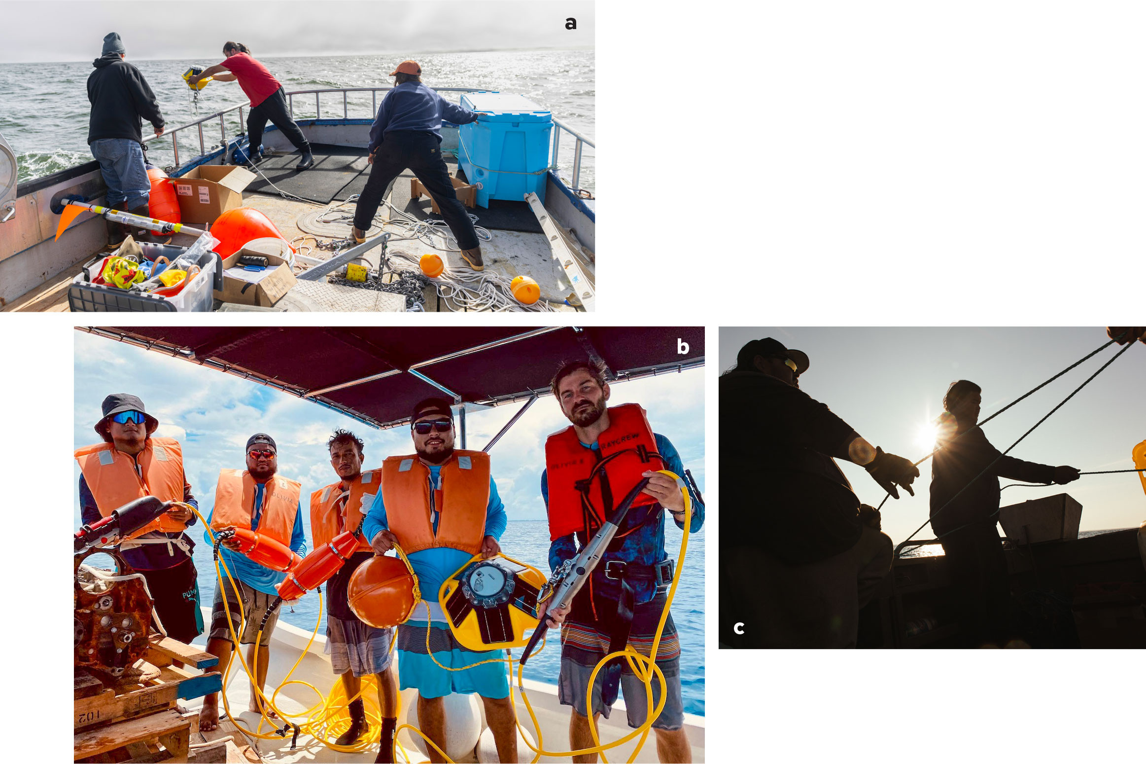
Beyond the need for wave data from lower-cost, more easily serviced buoys, this project focused on working together to overcome barriers and challenges as communities deployed buoys, addressed permitting requirements, and fostered autonomous stewardship into the future. To date, over 25 deployments have been successfully completed, and more than 10 more are planned in the 2024 season. The buoys will be maintained by the communities, aided as needed by staff in each region’s IOOS regional association. Life expectancy of a buoy is 3–5 years, depending on conditions. Backyard Buoys will be expanded to other geographic regions via IOOS funding.
After just the first season, all partners have commented on the utility of the data for keeping their vessels safe. An Arctic whaling captain (co-author Hopson) observed: “We were able to make safer decisions to go out whaling based on these wave buoys offshore. We are excited to get these out sooner next year!” The captains gained confidence in the project once they saw that the wave conditions they were experiencing offshore were similar to those measured by the nearby wave buoy.
While vessel safety is a priority for all three regions’ communities, the wave buoy data have additional applications beyond. On the Washington coast, the Quinault Indian Nation has lived for millennia at Taholah, located at the mouth of the Quinault River. As they say, “one road in, one road out.” Climate change brings higher temperature, sea level rise, greater storm ferocity, and more frequent storms. As coauthor and tribal marine resource scientist Joe Schumacker says, “The buoy data are allowing the opportunity to warn people of impending, building storms that can breach the sea wall. These data augment what little we have out there in the ocean for weather buoys. They are few and far between, and we live in a very remote area.”
Our Backyard Buoys project assures that each community maintains ownership of not only the buoys, but also ownership and permission sharing rights for the buoy data. In each of the three regions, the community decision has been to share the data publicly. A driving factor in this decision was to make the wave buoy data available to wave forecasters in order to improve their model forecast skill, particularly in hyperlocal regions near the communities. In American Samoa, for example, the mutual trust that the community partners have built with the PacIOOS wave modeler over the years was strengthened during the project, such that coauthor Scott Burch, Superintendent of the National Park of American Samoa, said, “We want PacIOOS and others to have the data because we are hoping the data will help you to improve the local wave forecasts for Manu‘a.” The Arctic whaling captains of the Alaska Eskimo Whaling Commission also agreed to share their wave buoy data publicly to ensure that the data help improve NOAA marine forecasts. The Quinault Indian Nation and Quileute Tribe in the Pacific Northwest also wanted the data to be publicly shared to increase discoverability and use of the data via the NANOOS data portal in addition to the Backyard Buoys app.
Lessons Learned
The Indigenous communities involved are now the stewards of the wave buoys within their own waters, and they have a plan for sustaining beyond the project in an ongoing partnership with the IOOS regional ocean observing systems. Aspects of our project that promote our collective success in capacity development include:
- Partners are united in need. While communities in each region needed local scale wave data, the “need” for the project also extended to other partners. Our industry partner, Sofar Ocean, aims to optimize a market for affordable, easily handled, and reliable buoys with future innovations and testing. The IOOS regional ocean observing systems involved are mandated to serve community ocean observing needs yet were not able to address requests for hyper-local wave data.
- Sharing expertise is key. The buoy technology was off-the-shelf. What was lacking was converging partners with different skill sets to co-design and co-produce a viable and sustainable plan to meet wave data needs. Communication is key. Our practice of establishing project-wide working groups for specific aspects (e.g., buoys, data tools, education) allowed sharing of knowledge and expertise across regions so that not every region needed an expert on each aspect.
- Co-production takes time, commitment, and trust. Partners were deeply committed to the success of the project in all its stages and were willing to engage in consistent communication. This was increasingly evident at in-person “all hands” meetings where regional partners from all backgrounds (Indigenous community leaders, oceanographers, educators, etc.) met and shared their stories. We were fortunate to start the project on a foundation of established and trusted relationships, some decades long, between the Indigenous community partners and the regional ocean observing systems. NSF curricula on team science further solidified the foundation through training on formalized relationship agreements and encouraging the outlining of expectations and responsibilities at the start.
- Flexibility and fit for purpose. As the project evolved, we adapted to include aspects we had not initially planned. Community partners emphasized that for the project to succeed, there needed to be fewer “gray hairs” in leadership, so we added an educational aspect in each region to foster awareness and inclusion of the younger generation. Our data delivery app was co-designed by all (Figure 2b), from Indigenous partners to wave modelers. When some of our Indigenous partners requested it in their native language, our app developer included this as an option, using their translations for all the text.
- Meeting known challenges intentionally: Project management is often under-scoped. Specific budgeting and inclusion of this aspect in our second phase improved efficiency. Finding management staff with permitting expertise was a critical need, as this process is detailed and time intensive.
Lasting Legacy
The partners share training and activities on various aspects, including wave buoy operations, mooring design, data analysis, Indigenous Knowledge integration, wave and climate modeling, engagement, and education. To date, all regions have deployed buoys, and the Indigenous partners are increasingly leading the deployment, recovery, and maintenance tasks, and they have autonomy over the data. All partners have thus far chosen to share the data publicly, to maximize safety, and to enable improvement of regional wave forecasts. This “win-win” aspect is a switch from the all too typical ocean research model, where communities are simply told what is going to happen in their waters, without much consideration for their needs or broader goals. Backyard Buoys works to leave a legacy that will foster expansion to other locations and teams.